Old Cumbria Gazetteer
 |
 |
|
||
| included in:- |
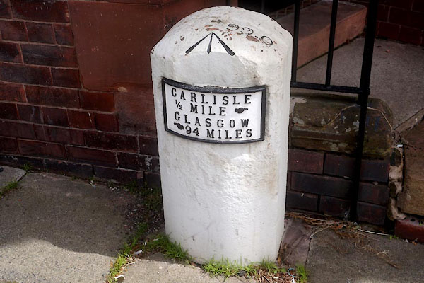
 road, Carlisle to Glasgow road, Carlisle to Glasgow |
|||
| road, Carlisle to Gretna | ||||
| Carlisle to Gretna | ||||
| Gretna to Carlisle | ||||
| civil parish:- | Carlisle (formerly Cumberland) | |||
| civil parish:- | Kimgmoor | |||
| civil parish:- | Rockcliffe (formerly Cumberland) | |||
| civil parish:- | Kirkandrews (formerly Cumberland) | |||
| county:- | Cumbria | |||
| locality type:- | road route | |||
| locality:- | Gretna Green | |||
| country:- | Scotland | |||
| 10Km square:- | NY35 | |||
| 10Km square:- | NY36 | |||
|
|
||||
| evidence:- | old map:- OS County Series (Cmd 10 9) |
|||
| source data:- | Maps, County Series maps of Great Britain, scales 6 and 25
inches to 1 mile, published by the Ordnance Survey, Southampton,
Hampshire, from about 1863 to 1948. alongside the road:- "Magnetic Telegraph" |
|||
|
|
||||
| evidence:- | old map:- Donald 1774 (Cmd) |
|||
| source data:- | Map, hand coloured engraving, 3x2 sheets, The County of Cumberland, scale about 1
inch to 1 mile, by Thomas Donald, engraved and published by Joseph Hodskinson, 29
Arundel Street, Strand, London, 1774. D44056D.jpg road out of town item:- Carlisle Library : Map 2 Image © Carlisle Library |
|||
|
|
||||
| evidence:- | old map:- Ford 1839 map |
|||
| source data:- | Map, uncoloured engraving, Map of the Lake District of
Cumberland, Westmoreland and Lancashire, scale about 3.5 miles
to 1 inch, published by Charles Thurnam, Carlisle, and by R
Groombridge, 5 Paternoster Row, London, 3rd edn 1843.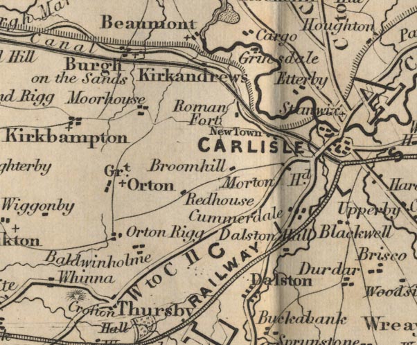 FD02NY35.jpg 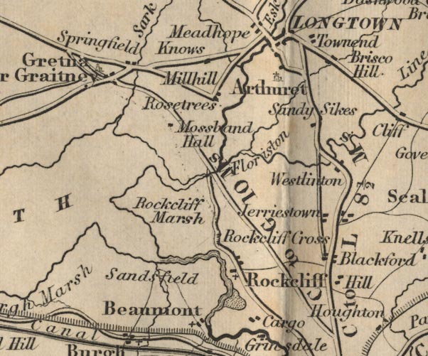 FD02NY36.jpg "C to G 10 Ms." item:- JandMN : 100.1 Image © see bottom of page |
|||
|
|
||||
| evidence:- | old map:- Bell 1892 |
|||
| source data:- | Map, colour lithograph, Road Map of Cumberland, by George Joseph
Bell, scale about 2.5 miles to 1 inch, printed by Charles
Thurnam and Sons, Carlisle, Cumberland, 1892.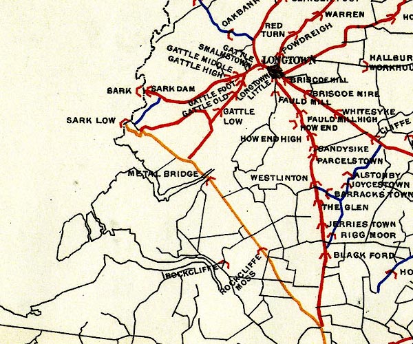 BEL9NY36.jpg  BEL9NY35.jpg orange - disturnpiked 'main road' under section 13 of the Highways Act 1878 since 1 September 1883 Road map of Cumberland showing County Bridges item:- Carlisle Library : Map 38 Images © Carlisle Library |
|||
|
|
||||
| evidence:- | old text, old text:- Harper 1907 placename:- English Road |
|||
| source data:- | HP01p155.txt Page 155:- 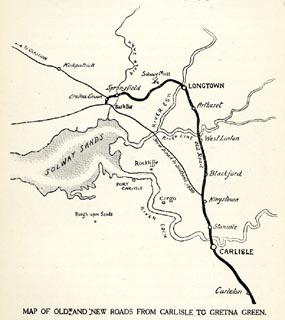 click to enlarge click to enlargeHP01M2.jpg "MAP OF OLD AND NEW ROADS FROM CARLISLE TO GRETNA GREEN." item:- JandMN : 1055.27 Image © see bottom of page |
|||
| source data:- | HP01p154.txt Page 154:- "..." "The geography of Gretna and the Border is, so far as roads are concerned, somewhat involved, and requires careful explanation. Up to 1830, when the wide-spreading sands of the Esk were bridged, the way for coaches and all road traffic lay circuitously through Longtown to the right of where the fork of the roads now occurs [at Kingstown]; but in that year the New Road, or the "English Road," as it commonly was called, was opened, .." "..." HP01p159.txt Page 159:- "..." "THE popularity of Gretna Green elopements dated from the passing of Lord Chancellor Hardwicke's Marriage Act of 1754, by which it was declared that "Any person solemnising matrimony in any other place than a church or public chapel, without banns, or other license, shall, on conviction, be adjudged guilty of felony, and be transported for fourteen years, and all such marriages shall be void."" "This measure was expressly designed to put an end to the long-continued and growing scandal of the so-called "Fleet marriages," which had first attracted attention in 1674. The Fleet marriages, performed by chaplains of the Fleet Prison, in London, led to many abuses. Made on the spur of the moment, between prisoners there, incarcerated for debt or other misdemeanours, and the visitors permitted free access under the lax discipline of that time, the most fearful alliances were perpetrated wholesale. Drunken prisoners, dissolute women, and parsons who richly deserved being unfrocked were the actors in these scenes, almost exactly matched by the similar clandestine marriages performed on application, at all hours of day or night, by the chaplains of the Savoy, and by the clerical owners of proprietary chapels in Mayfair." "..." HP01p160.txt Page 160:- "..." "...But the Act, beneficent as it was, did not pass without great opposition, and even when it became law, its operation was confined to England; with the result that the only difficulty in the way of a clandestine marriage that should be sufficiently legal was that of making a journey out of England; whether across the English Channel to Calais, or into the Isle of Man, or across the Border into Scotland, was immaterial. ..." "The Border, in fact, was destined to be, above all others, the place to which eloping couples sped. ..." HP01p161.txt Page 161:- "... It was ... quite in keeping with old Border history that, when brute force went out and legal enormities took its place, is (sic) should be the refuge of eloping lovers, of whom a very large proportion were fortune-hunting scamps running away with silly, sentimental schoolgirls." "The flight into Scotland afforded exceptional facilities, for marrying across the Border has ever been (and still is) the simplest of affairs; the chief difficulty being still, as Lord" "Eldon long ago observed, to find out what does not constitute a marriage in Scotland. ..." |
|||
| source data:- | HP01p161.txt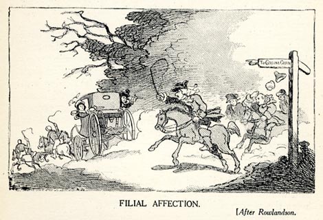 click to enlarge click to enlargeHP0128.jpg "FILIAL AFFECTION. (After Rowlandson." item:- JandMN : 1055.30 Image © see bottom of page HP01p162.txt Page 162:- "Preposterous although it may seem, the difficulty in Scotland is, not to get married, but how not. The mere verbal acknowledgements exchanged, "This is my wife," "This is my husband," are all-sufficient, and equally binding as the most formal marriage-license ever issued by a bishop to his "dearly beloved;" and even words spoken in jest, without any wish or desire that they should be seriously considered, are binding. It is not to be supposed that novelists have remained ignorant of these quaint customs, and indeed Gretna Green in particular, and Scottish marriage-laws in general, give point to Wilkie Collins's "Man and Wife," Mrs. Henry Wood's "Elster's Folly," and J. M. Barrie's "Little Minister," among other novels." "..." |
|||
| source data:- | HP01p163.txt Page 163:- 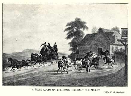 click to enlarge click to enlargeHP0129.jpg ""A FALSE ALARM ON THE ROAD: 'TIS ONLY THE MAIL!" (After C. B. Newhouse" item:- JandMN : 1055.31 Image © see bottom of page HP01p165.txt Page 165:- "..." "Gretna stands to all the world for runaway matches, but although by far the most popular place, it was by no means the only one. ..." "On this West Coast, however, on the "new" road to Gretna, the actual crossing of the Border is at the passage of the little river Sark, half a mile before you come to that more famous hamlet. Although Gretna is pre-eminently famed, and Springfield, just short of it, comes second in popular estimation, ..." HP01p166.txt Page 166:- "... the simple questions that sufficed: "Were they single?" and "Did they wish to become man and wife?" It was all over by the time the foaming enemy was cursing and kicking outside the barred and bolted door; ..." "..." HP01p167.txt Page 167:- "..." "Painters and engravers found the romance of Gretna greatly to their minds, and numerous pictures exist of scenes upon the road, and at Gretna itself. Two of the most striking are those by C. B. Newhouse, showing "A False Alarm on the Road: 'Tis only the Mail," and "One Mile from Gretna: The Governor in sight, with a Screw loose." In the first we" HP01p168.txt Page 168:- "see the love-lorn ones, halted in front of a wayside inn, the post-boys running out with fresh horses, while with a rush the Royal Mail suddenly dashes by. They think for the moment they are overtaken, but sink back with the heartfelt ejaculation, "'Tis only the Mail." In the second picture we have the post-boys whipping and spurring on the frantic horses, and the prospective bridegroom standing up in the chaise, holding out a further inducement to speed, in the shape of a bag which, by the size of it, would appear to contain a modest competency for life. On the summit of a distant hill the governor's chaise appears to have met with an accident, and the chase is virtually over." |
|||
| source data:- | HP01p169.txt Page 169:- 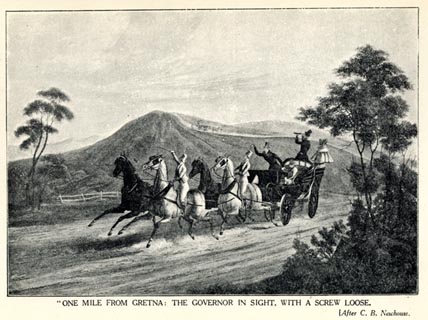 click to enlarge click to enlargeHP0132.jpg ""ONE MILE FROM GRETNA: THE GOVERNOR IN SIGHT, WITH A SCREW LOOSE. (After C. B. Newhouse." item:- JandMN : 1055.34 Image © see bottom of page |
|||
| source data:- | HP01p173.txt Page 173:- 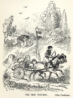 click to enlarge click to enlargeHP0133.jpg "THE DEAF POST-BOY. (After Cruikshank." item:- JandMN : 1055.35 Image © see bottom of page HP01p168.txt Page 168:- "The "Deaf Postilion," pictured by George Cruikshank, seems to have been a real person, and the incident he illustrates to have really happened. He was stone-deaf, and when furiously driving an anxious couple towards the goal of their hopes, failed to notice that, in the lurching and plunging of the chaise, the springs had broken, leaving the body behind, while he hastened on, blissfully unconscious of the disaster, with the fore-carriage." |
|||
|
|
||||
| evidence:- | old text:- Burrow 1920s placename:- |
|||
| source data:- | Road book, strip maps with parts in Westmorland, Cumberland etc,
irregular scales about 1.5 miles to 1 inch, by E J Burrow and
Co, Cheltenham, Gloucestershire, 1920s. "[Carlisle] ... A modern but striking architectural work is the handsome bridge by which we cross the Eden to continue our northward journey." "Scotland is now less than ten miles ahead and, like many runaway couples of the past, we hasten now to Gretna Green. The actual border is crossed at Sark Bar toll-house, where the small River Sark is also crossed, a mile before reaching Gretna Green village. ..." |
|||
|
|
||||
| evidence:- | old strip map:- Geographia 1925 |
|||
| source data:- | Road book, with road strip maps and gradient diagrams, Premier Road Book of Great
Britain, by Alexander Gross and F Waite-Browne, published by Geographia, 55 Fleet
Street, London, about 1925?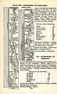 click to enlarge click to enlargeGE1153.jpg "Route 370. - DUMFRIES TO CARLISLE." item:- Hampshire Museums : B1990.161.4 Image © see bottom of page |
|||
|
|
||||
| places:- | Carlisle Stanwix, Carlisle Todhills, Rockcliffe Sark Bridge, Kirkandrews Gretna, Scotland |
|||
|
|
||||
| places:- |
|
|||
|
||||
|
||||
|
||||
|
||||
|
||||
|
||||
|
||||
|
||||
|
||||
Lakes Guides menu.