 |
 |
   |
|
|
|
Verterae |
| locality:- |
Brough Castle |
| locality:- |
Church Brough |
| locality:- |
Brough |
| civil parish:- |
Brough (formerly Westmorland) |
| county:- |
Cumbria |
| locality type:- |
roman fort |
| 1Km square:- |
NY79141405 (about) |
| 1Km square:- |
NY7914 |
| 10Km square:- |
NY71 |
|
|
| evidence:- |
old map:- OS County Series (Wmd 16 15)
placename:- Verterae
|
| source data:- |
Maps, County Series maps of Great Britain, scales 6 and 25
inches to 1 mile, published by the Ordnance Survey, Southampton,
Hampshire, from about 1863 to 1948.
|
|
|
| evidence:- |
old map:- Stukeley 1723
placename:- Brough
placename:- Verteris
|
| source data:- |
Road map, uncoloured engraving, the Antonine Itineraries through
Britain, scale about 55 miles to 1 inch, plotted by William
Stukeley, 1723, published London, 1724.
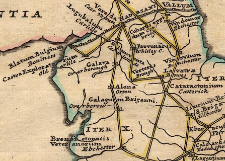 click to enlarge click to enlarge
Stu1Cm.jpg
"Verteris / Brough"
item:- Hampshire Museums : FA2001.171
Image © see bottom of page
|
|
|
| evidence:- |
descriptive text:- Simpson 1746
placename:- Caesar's Tower
|
| source data:- |
Atlas, three volumes of maps and descriptive text published as
'The Agreeable Historian, or the Compleat English Traveller
...', by Samuel Simpson, 1746.
 goto source goto source
Page 1024:- "..."
"Brough, ... is divided into [two]"
 goto source goto source
Page 1025:- "... Church Brough, ... with ... a small Fort called Caesar's Tower, ..."
|
|
|
| evidence:- |
old text:- Pennant 1773
placename:- Verterae
|
| source data:- |
Book, A Tour from Downing to Alston Moor, 1773, by Thomas
Pennant, published by Edward Harding, 98 Pall Mall, London, 1801.
 goto source goto source
Pennant's Tour 1773, page 135 "..."
"... Church Brough, a village noted for its ancient castle, probably built on the site of the Roman station Verterae, where was placed a band of"
 goto source goto source
Pennant's Tour 1773, page 136 "Directores, a sort of soldiery supposed to have been employed as guides. ..."
|
|
|
| evidence:- |
old map:- Pennant 1777
placename:- Verterae
|
| source data:- |
Map, hand coloured engraving, A Map of Scotland, Hebrides and
Part of England, drawn for Thomas Pennant, engraved by J Bayly,
published by Benjamin White, London, 1777.
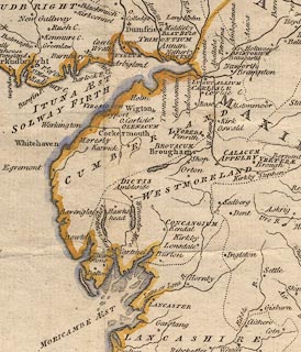 click to enlarge click to enlarge
PEN1Cm.jpg
"VERTERAE / Brough"
circle; buildings, village, etc
item:- private collection : 66
Image © see bottom of page
|
|
|
| evidence:- |
descriptive text:- Lowther 1780s-90s
placename:- Verterae
|
| source data:- |
Scrapbook, 4 volumes, of descriptive texts, maps, and prints of
views and coats of arms, for Westmorland and Cumberland,
assembled by a member of the Lowther Family, late 18th early
19th century.
Text with a print, engraving, Brough Castle, drawn by Samuel Hooper, engraved by Sparrow,
1775:- "... CAMDEN describing this country [round Brough] says, 'Here Eden seems to stop its
course, that it may receive some rivulets; upon one of which, scarce two miles from
Eden itself, stood Verterae, an ancient town mentioned by Antoninus and the Notitia;
from the latter of which we learn, that in the decline of the Roman empire a Praefect
of the Romans quartered there with a band of the Directores. ..."
|
|
|
| evidence:- |
old text:- Camden 1789 (Gough Additions)
placename:- Verterae
|
| source data:- |
Book, Britannia, or A Chorographical Description of the Flourishing Kingdoms of England,
Scotland, and Ireland, by William Camden, 1586, translated from the 1607 Latin edition
by Richard Gough, published London, 1789.
 goto source goto source
Page 157:- "..."
"Verterae is no doubt rightly fixed at Brough. The course of the military way is absolutely
certain; the remains are generally so grand, and it is so rarely interrupted, and
then only for so short a space, that we have never the least difficulty about it."
"..."
"... upper or church Brough ... Here also stands the castle ... and the fort mentioned
by Camden called Caesar's tower."
|
|
|
| evidence:- |
old text:- Camden 1789
placename:- Verterae
item:- Antonine Itineraries; Notitia Dignitatum
|
| source data:- |
Book, Britannia, or A Chorographical Description of the Flourishing Kingdoms of England,
Scotland, and Ireland, by William Camden, 1586, translated from the 1607 Latin edition
by Richard Gough, published London, 1789.
 goto source goto source
Page 148:- "[VER]TERAE, an antient town mentioned by Antoninus and the Notitia, which last adds that in the decline of the Roman empire here was a Roman praefect stationed with a Numerus Directorum. The town at present reduced to a mean village, fortified with a small rampart, has changed its name to Burgh, by our people called Burgh under Stanemore. Under the later emperors, to remark once for all, small castles proper for war and well supplied, began to be called Burghs by a new name, which, after the removal of the empire into the east, the Germans and other nations seemed to have borrowed from the Greek πυρος, whence the Burgundiones has their name from inhabiting Burg, the common term at that time for dwellings thick scattered on borders. I find no further mention of this place except that in the beginning of the Norman government the English here formed a conspiracy against William the Norman. I would venture to affirm this Burgh to be VERTERAE for this single reason, that the distance between it and Lavatrae one way, and Brovonacum the other, reduced to Italian miles, exactly corresponds with numbers in Antoninus, and the Roman military way with a visible ridge runs this way to BROVONACUM through ABALLABA, mentioned in the Notitia, which still retains its name with so little variation as to discover itself most clearly, and remove every doubt. For we call it by shortness from Aballaba Apelby. This place"
|
|
|
| evidence:- |
site plan:- Curwen 1913
|
| source data:- |
Site plan, lithograph, Site Plan of Bough Castle, Brough, Westmorland, published for
the Cumberland and Westmorland Antiquarian and Archaeological Society by Titus Wilson,
Kendal, Westmorland, 1913.
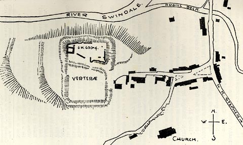 click to enlarge click to enlarge
CW0114.jpg
On p.81 of The Castles and Fortified Towers of Cumberland, Westmorland, and Lancashire
North of the Sands, by John F Curwen.
printed at bottom:- "SITE PLAN OF BROUGH CASTLE."
item:- Armitt Library : A782.14
Image © see bottom of page
|
|
|
| evidence:- |
site plan:- Historical Monuments 1936
|
| source data:- |
Site plan, uncoloured lithograph, Brough Castle Roman Foundations under Keep, Church
Brough, Brough, Westmorland, scale about 1 to 290, published by Royal Commission on
Historical Monuments England, London, 1936.
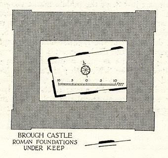 click to enlarge click to enlarge
HMW036.jpg
On p.48 of the Inventory of the Historical Monuments in Westmorland.
printed, bottom "BROUGH CASTLE / ROMAN FOUNDATIONS / UNDER KEEP"
RCHME no. Wmd, Brough 1
item:- Armitt Library : A745.36
Image © see bottom of page
|
|
|
| evidence:- |
text:- Rivet and Smith 1979
placename:- Verteris
placename:- Valteris
placename:-
|
| source data:- |
The roman fort at Brough Castle, Westmorland.
|
|
|
| evidence:- |
old map:- Horsley 1732
placename:- Verterae
placename:- Brough
|
| source data:- |
Map, uncoloured engraving, Britannia Antiqua, roman Britain,
scale about 50 miles to 1 inch, by John Horsley, perhaps 1732,
edition published about 1869?
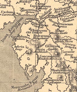 click to enlarge click to enlarge
HOR1Cm.jpg
"Verterae / Brough"
item:- JandMN : 429
Image © see bottom of page
|
|
|
|
: 1958: Trans CWAAS: series 2 vol.58: pp.31-56
|
|
|


 click to enlarge
 goto source
 goto source
 goto source
 goto source
 click to enlarge
 goto source
 goto source
 click to enlarge
 click to enlarge
 click to enlarge