 Old Cumbria Gazetteer
 |
 |
|
|||||||||||||||||||||||||||
| road, Borrowdale and Buttermere | |||||||||||||||||||||||||||||
| Borrowdale and Buttermere | |||||||||||||||||||||||||||||
| Buttermere and Borrowdale | |||||||||||||||||||||||||||||
| road to Scale Hill | |||||||||||||||||||||||||||||
| B5289 | |||||||||||||||||||||||||||||
| civil parish:- | Keswick (formerly Cumberland) | ||||||||||||||||||||||||||||
| civil parish:- | Above Derwent (formerly Cumberland) | ||||||||||||||||||||||||||||
| civil parish:- | Borrowdale (formerly Cumberland) | ||||||||||||||||||||||||||||
| civil parish:- | Buttermere (formerly Cumberland) | ||||||||||||||||||||||||||||
| civil parish:- | Lorton (formerly Cumberland) | ||||||||||||||||||||||||||||
| civil parish:- | Embleton (formerly Cumberland) | ||||||||||||||||||||||||||||
| civil parish:- | Cockermouth (formerly Cumberland) | ||||||||||||||||||||||||||||
| county:- | Cumbria | ||||||||||||||||||||||||||||
| locality type:- | road route | ||||||||||||||||||||||||||||
| 10Km square:- | NY22 | ||||||||||||||||||||||||||||
| 10Km square:- | NY21 | ||||||||||||||||||||||||||||
| 10Km square:- | NY11 | ||||||||||||||||||||||||||||
| 10Km square:- | NY12 | ||||||||||||||||||||||||||||
|
|
|||||||||||||||||||||||||||||
| evidence:- | old text:- Gents Mag |
||||||||||||||||||||||||||||
| source data:- | Magazine, The Gentleman's Magazine or Monthly Intelligencer or
Historical Chronicle, published by Edward Cave under the
pseudonym Sylvanus Urban, and by other publishers, London,
monthly from 1731 to 1922. goto source goto sourceGentleman's Magazine 1751 p.52 "..." "We left Keswic at 9 in the morning, and wou'd have proceeded by water, and sent our horses overland, but this way of travelling wou'd have cost us more time than we cou'd afford. On our left, in the way from Keswic, a ridge of rude craggy rocks extended near 4 miles; on our right was Keswic lake, and beyond it a group of pyramidical hills, which formed an uncommon appearance. At the head of Keswic lake, the Darwent is contracted to a narrow river, and runs between two precipices, covered with wood to the top, the perpendicular height of which is 800 yards. On approaching this place we imagined it to be our ne plus ultra, but our guide soon convinced us that we were mistaken. On the West side of the Darwent in this Herculean streight, and directly under one of these stupendous precipices lies the village of Grange. The white prominent rocks, which were discovered at an immense height, thro' the apertures of the wood, would have filled a poetical imagination with the ideas of the Dryades, the Bacchum in remotis, and other fables of antiquity. Here we were obliged many times to alight, the gut being very rocky, and the mountains would indeed have been impassable, if the river had not made a way." "We had now reached the Bowder stone of Barrowdale, ... it lies close by the road side, on the right hand, ... From hence we had good road thro' groves of hazel, which in this vale, as there is no occasion for hedges, grow very large, and bear excellent nuts." "..." |
||||||||||||||||||||||||||||
|
|
|||||||||||||||||||||||||||||
| evidence:- | old map:- Gents Mag 1751 |
||||||||||||||||||||||||||||
| source data:- | Map, uncoloured engraving, Map of the Black Lead Mines in
Cumberland, and area, scale about 2 miles to 1 inch, by George
Smith, published in the Gentleman's Magazine, 1751.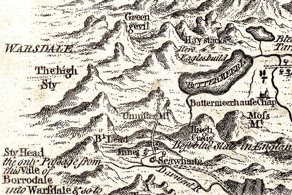 GM1305.jpg 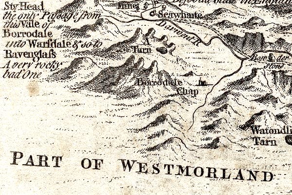 GM1309.jpg 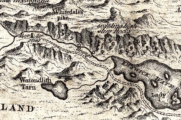 GM1310.jpg 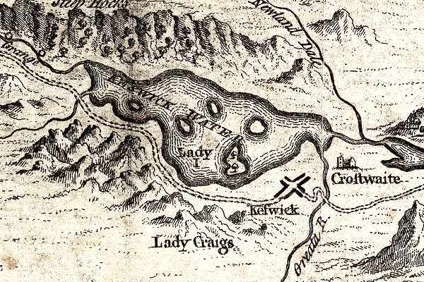 GM1311.jpg double line; road, dotted Note that the label "Way to Borrodale" is on the road that George Smith takes to get to Keswick and then Borrowdale, coming through Orthwaite 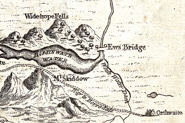 GM1313.jpg item:- JandMN : 114 Image © see bottom of page |
||||||||||||||||||||||||||||
|
|
|||||||||||||||||||||||||||||
| evidence:- | old map:- Donald 1774 (Cmd) |
||||||||||||||||||||||||||||
| source data:- | Map, hand coloured engraving, 3x2 sheets, The County of Cumberland, scale about 1
inch to 1 mile, by Thomas Donald, engraved and published by Joseph Hodskinson, 29
Arundel Street, Strand, London, 1774. double line, narrower, solid or dotted with a dot and number at 1 mile intervals; road 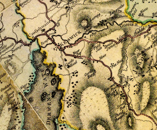 D4NY22SE.jpg 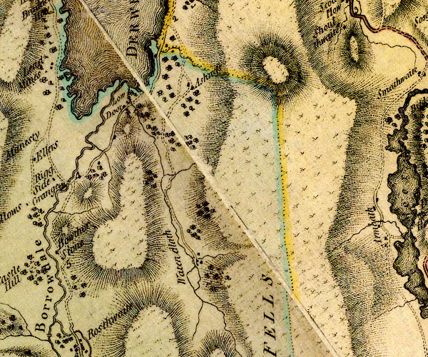 D4NY21NE.jpg 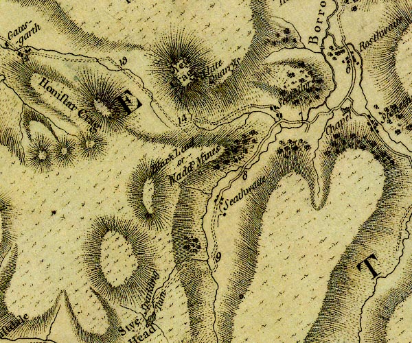 D4NY21SW.jpg goes beyond Seathwaite to the foot of the Styhead pass item:- Carlisle Library : Map 2 Images © Carlisle Library |
||||||||||||||||||||||||||||
|
|
|||||||||||||||||||||||||||||
| evidence:- | old map:- Donald 1774 (Cmd) |
||||||||||||||||||||||||||||
| source data:- | Map, hand coloured engraving, 3x2 sheets, The County of Cumberland, scale about 1
inch to 1 mile, by Thomas Donald, engraved and published by Joseph Hodskinson, 29
Arundel Street, Strand, London, 1774. double line, narrower, solid or dotted with a dot and number at 1 mile intervals; road 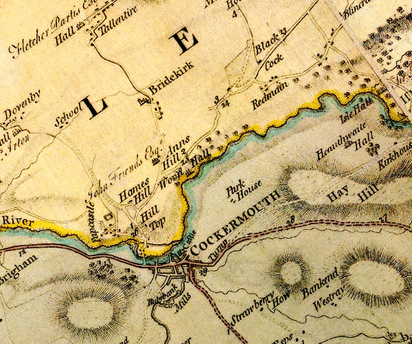 D4NY13SW.jpg 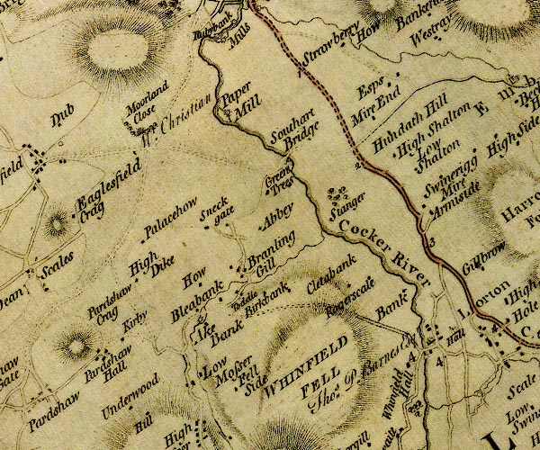 D4NY12NW.jpg 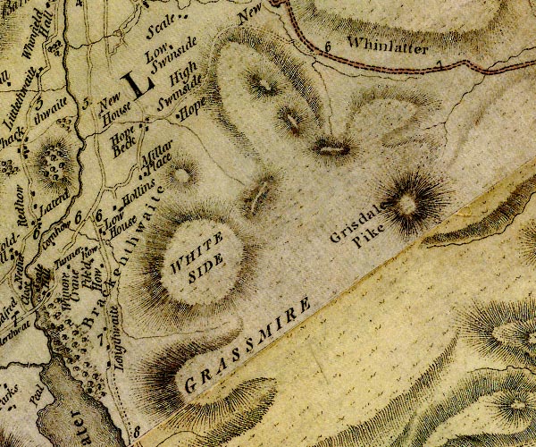 D4NY12SE.jpg 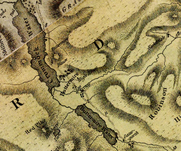 D4NY11NE.jpg D4NY21SW.jpg to junction S of Seatoller item:- Carlisle Library : Map 2 Images © Carlisle Library |
||||||||||||||||||||||||||||
|
|
|||||||||||||||||||||||||||||
| evidence:- | old map:- Donald 1774 (Cmd) |
||||||||||||||||||||||||||||
| source data:- | Map, hand coloured engraving, 3x2 sheets, The County of Cumberland, scale about 1
inch to 1 mile, by Thomas Donald, engraved and published by Joseph Hodskinson, 29
Arundel Street, Strand, London, 1774. double line, narrower, solid or dotted with a dot and number at 1 mile intervals; road D4NY22SE.jpg D4NY21NE.jpg D4NY21SW.jpg goes beyond Seathwaite to the foot of the Styhead pass item:- Carlisle Library : Map 2 Images © Carlisle Library |
||||||||||||||||||||||||||||
|
|
|||||||||||||||||||||||||||||
| evidence:- | old map:- Donald 1774 (Cmd) |
||||||||||||||||||||||||||||
| source data:- | Map, hand coloured engraving, 3x2 sheets, The County of Cumberland, scale about 1
inch to 1 mile, by Thomas Donald, engraved and published by Joseph Hodskinson, 29
Arundel Street, Strand, London, 1774. double line, narrower, solid or dotted with a dot and number at 1 mile intervals; road D4NY13SW.jpg D4NY12NW.jpg D4NY12SE.jpg D4NY11NE.jpg D4NY21SW.jpg to junction S of Seatoller item:- Carlisle Library : Map 2 Images © Carlisle Library |
||||||||||||||||||||||||||||
|
|
|||||||||||||||||||||||||||||
| evidence:- | descriptive text:- West 1778 (11th edn 1821) |
||||||||||||||||||||||||||||
| source data:- | Guide book, A Guide to the Lakes, by Thomas West, published by
William Pennington, Kendal, Cumbria once Westmorland, and in
London, 1778 to 1821. goto source Page 92:- "The road is along Barrowside, on the margin of the lake, narrow, yet safe. It soon enters a glade, through which the lake is sweetly seen by turns. In approaching the ruins of Gowdar-crag, which hangs towering forward, the mind recoils at the huge fragments of crags, piled up on both sides, which are seen through a thicket of rocks and wood. But there is nothing of the danger remaining that Mr. Gray apprehended here; the road being carefully kept open. Proceed by the bridge of one arch, over Park-gill, and another over Barrow-beck. Here Gowdar-crag presents itself in all its terrible majesty of rock, trimmed with trees that hang from its numerous fissures. Above this is seen a towering grey rock, rising ma-" goto sourcePage 93:- "[ma]jestically rude, and near it, Shuttenoer, a spiral rock not less in height, hanging more forward over its base. Betwixt these, an awful chasm is formed, through which the waters of Watanlath are hurled. This is the Niagara of the lake, the renowned cataract of Lowdore. ... The wonderful scenes, peculiar to this part, continue to the gorge of Borrowdale [2], and higher; and Castle-crag may be seen, in the centre of the amphitheatre, threatening to block up the pass it once defended. ..." "[2] This scene is the subject of No.2, of Mr. Farrington's views." goto sourcePage 96:- "..." "Mr. Gray was so much intimidated with the accounts of Borrowdale, that he proceeded no farther than Grange. But no such difficulties as he feared are now to be met with. The road into Borrowdale is improved since his time, at least as far as is necessary for any one to proceed to see what is curious. It serpentizes through the pass above Grange; and though upon the edge of a precipice that hangs over the river, it is, nevertheless, safe. ..." "..." goto sourcePage 100 (The other route down the valley):- "Return to Keswick, by Grange, and if the sun shines in the evening, the display of rocks on the opposite shore, from Castle-rock to Wallow-crag, is amazingly grand. The parts are the same as in the morning ride, but the" goto sourcePage 101:- "dispositions are entirely new. The crystal surface of the Lake reflecting waving woods and rocks, backed by the finest arrangement of lofty mountains, intersecting and rising above each other, in great variety of forms, is a scene not to be equalled elsewhere. The whole ride down the western side is pleasant, though the road is but indifferent." goto sourceAddendum; Mr Gray's Journal, 1769 Page 203:- "Oct. 3. A heavenly day; rose at seven, and walked out [from Keswick] under the conduct of my landlord to Borrowdale; the grass was covered with a hoar frost, which soon melted and exhaled a thin blueish smoke; crossed the meadows obliquely, catching a diversity of views among the hills, over the lake and islands, and changing prospect at every ten paces. Left Cockshut ... and Castle-hill, a loftier and more rugged hill behind me, and drew near the foot of Wallow-cragg, whose bare and rugged brow, cut perpendicularly down above 400 feet, (as I guess, though the people call it much more) awfully overlooks the way. Our path here tends to the left, and the ground gently rising, and covered with a glade of scattered trees and bushes on the very margin of the water, opens both ways the most delicious view that my eyes every beheld. Opposite are the thick woods of Lord Egremont, and Newland valley, with green and smiling fields embosomed in the dark cliffs; to the left, the jaws of Borrowdale, with that turbulent chaos of mountain behind mountain, rolled in confusion; beneath you, and stretching far away to the right, the shining purity of the lake-reflecting rocks, woods, fields, and inverted tops of hills, just ruffled by the breeze, enough to show it is alive, with the white buildings of Keswick, Crosthwaite church, and Skiddaw, for a back-ground at a distance. Behind you the magnificent heights of Wallow-crag: here the glass played its part divinely; the place is called Carf-close-reeds; and I choose to set down these barbarous names, that any body may enquire on the place, and easily find the particular station that I mean. This scene continues to Barrowgate, and a little further, passing a brook called Barrow-beck, we entered Borrowdale: the crags named Lowdore-banks began now to impend terribly over the way, and more terribly when you hear that three years since an immense mass of rock tumbled at once from the brow, barred all access to the dale (for this is the only road) till they could work their way through it. Luckily no one was passing by at the time of this fall; but down the side of the mountain, and far into the lake, lie dispersed the huge fragments of this" goto sourcePage 204:- "ruin, in all shapes and in all directions: something farther we turned aside into a coppice, ascending a little in front of Lowdore water-fall: the height appeared to be about 200 feet, the quantity of water not great, though (these three days excepted) it hath rained daily for near two months before; but then the stream was nobly broken, leaping from rock to rock, and foaming with fury. On one side a towering crag, that spired up to equal, if not overtop, the neighbouring cliffs (this lay all in shade and darkness) on the other hand a rounder, broader, projecting hill shagged with wood, and illuminated by the sun, which glanced sideways on the upper part of the cataract. The force of the water wearing a deep channel in the ground, hurries away to join the lake. We descended again, and passed the stream over a rude bridge. Soon after we came under Gowdar-crag, a hill more formidable to the eye, and to the apprehension, than that of Lowdore; the rocks at top deep-cloven perpendicularly by the rains, hanging loose and nodding forwards, seen just starting from their base in shivers. The whole way down, and the road on both sides, is strewed with piles of the fragments, strangely thrown across each other, and of a dreadful bulk; the place reminds me of those passes in the Alps, where the guides tell you to move with speed, and say nothing, lest the agitation of the air should loosen the snows above, and bring down a mass that would overwhelm a caravan, I took their counsel here, and hastened on in silence." "Non ragioniam di lor, ma guarda e passa." "The hills here are clothed all up their steep sides with oak, ash, birch, holly, &c., ... Here we met a civil young farmer overseeing his reapers (for it is now oat harvest) who conducted us to a neat white house in the village of Grange, which is built on a rising ground in the midst of a valley; round it the mountains" goto sourcePage 205:- "form an awful amphitheatre, and through it obliquely runs the Derwent, clear as glass, and showing under its bridge every trout that passes. Beside the village rises a round eminence of a rock covered entirely in old trees, and over that more proudly towers Castle-cragg, invested also with wood on its sides, and bearing on its naked top some traces of a fort, said to be Roman, By the side of this hill, which almost blocks up the way, the valley turns to the left, and contracts its dimensions till there is hardly any road but the rocky bed of the river. The wood of the mountains increases, and their summits grow loftier to the eye, and of more fantastic forms; among them appear Eagle's-cliff, Dove's-nest, Whitedale pike, &c. celebrated in the annals of Keswick. The dale opens about four miles higher, till you come to Seathwaite, where lies the way, mounting the hill to the right, that leads to the wad-mines; all farther access is here barred to prying mortals, only there is a little path winding over the fells, and for some weeks in the year passable to the dalesmen; but the mountains know well that these innocent people will not reveal the mysteries of their ancient kingdom, 'the reign Chaos and Old Night,' only I learned that this dreadful road, divided again, leads one branch to Ravenglass, and the other to Hawkshead." "For me , I went no farther than the farmer's (better than four miles from Keswick) at Grange; ..." goto sourcePage 206:- "..." "We returned leisurely home the way we came, but saw a new landscape; the features indeed were the same in part, but many new ones were disclosed by the mid-day sun, and the tints were entirely changed: ... it was perfectly serene, and hot as mid-summer." |
||||||||||||||||||||||||||||
|
|
|||||||||||||||||||||||||||||
| evidence:- | old map:- Crosthwaite 1783-94 (But/Cru/Low) |
||||||||||||||||||||||||||||
| source data:- | Map, uncoloured engraving, An Accurate Map of Buttermere,
Crummock and Loweswater Lakes, scale about 3 inches to 1 mile,
by Peter Crosthwaite, Keswick, Cumberland, 1794, version
published 1800.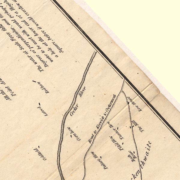 CT8NY12L.jpg 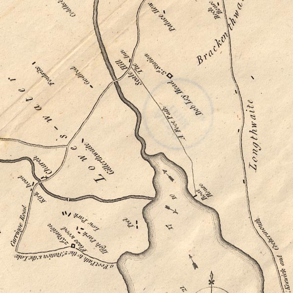 CT8NY12K.jpg 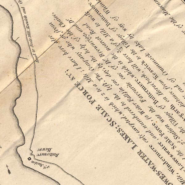 CT8NY11U.jpg "Road to Scale Hill, Keswick and Cockermouth" 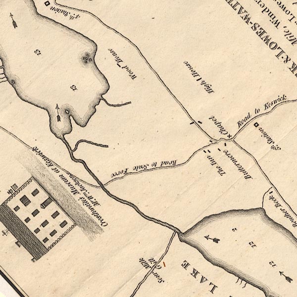 CT8NY11T.jpg 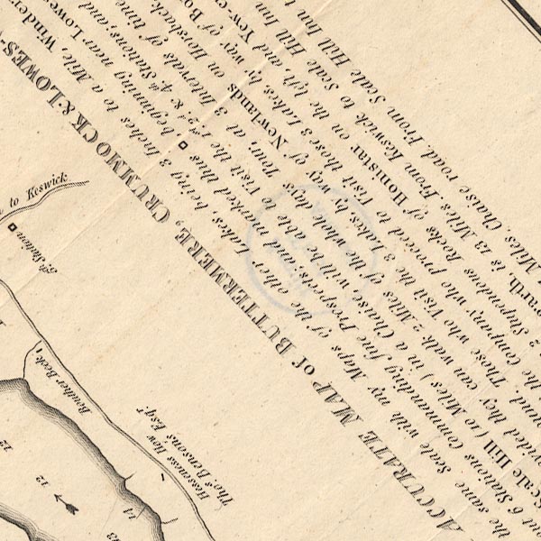 CT8NY11Y.jpg 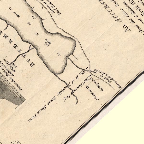 CT8NY11X.jpg Keswick to Buttermere via Honister Pass. In the title text:- "... The distance from Keswick to the Village of Buttermere, by Borrowdale and Gates-garth, is 13 Miles. ..." item:- Armitt Library : 1959.191.2 Image © see bottom of page |
||||||||||||||||||||||||||||
|
|
|||||||||||||||||||||||||||||
| evidence:- | old map:- Crosthwaite 1783-94 (But/Cru/Low) |
||||||||||||||||||||||||||||
| source data:- | Map, uncoloured engraving, An Accurate Map of Buttermere,
Crummock and Loweswater Lakes, scale about 3 inches to 1 mile,
by Peter Crosthwaite, Keswick, Cumberland, 1794, version
published 1800. CT8NY11T.jpg "Road to Keswick" The road via Newlands Hause.  CT2NY22K.jpg "To Buttermere" item:- Armitt Library : 1959.191.2 Image © see bottom of page |
||||||||||||||||||||||||||||
|
|
|||||||||||||||||||||||||||||
| evidence:- | old map:- Crosthwaite 1783-94 (Der) |
||||||||||||||||||||||||||||
| source data:- | Map, uncoloured engraving, An Accurate Map of the Matchless Lake
of Derwent, ie Derwent Water, scale about 3 inches to 1 mile, by
Peter Crosthwaite, Keswick, Cumberland, 1783, version published
1800. CT2NY22K.jpg  CT2NY21P.jpg 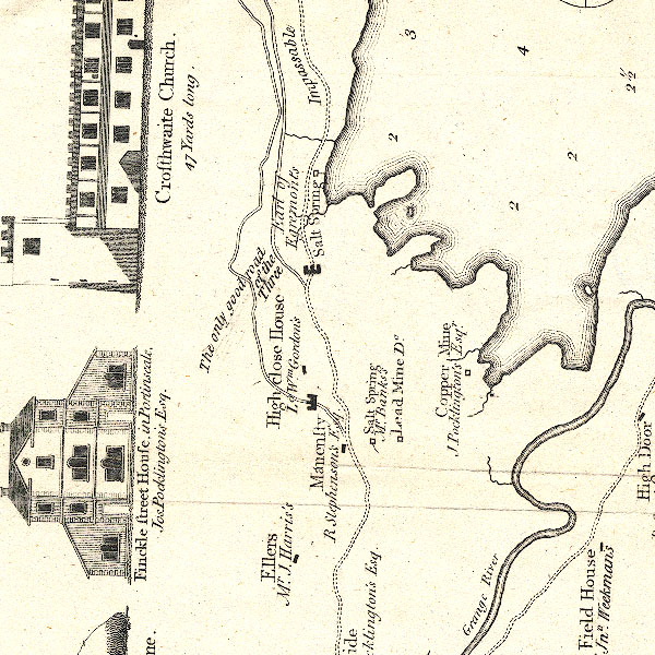 CT2NY21N.jpg 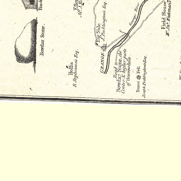 CT2NY21M.jpg Three routes are shown, from west to east these are labelled:- "The New Road Impassable / The only good road of the Three / Impassable" item:- Armitt Library : 1959.191.3 Image © see bottom of page |
||||||||||||||||||||||||||||
|
|
|||||||||||||||||||||||||||||
| evidence:- | old text:- Gilpin 1786 placename:- Castellet |
||||||||||||||||||||||||||||
| source data:- | Book, Observations, Relative Chiefly to Picturesque Beauty, Made
in the Year 1772, on Several Parts of England, Particularly the
Mountains, and Lakes of Cumberland Westmoreland, by Rev William
Gilpin, 1772-74; published 1786-1808. goto source vol.1 p.187 "..." "Detached from this continent of precipice, if I may so speak, stands a rocky hill, known by the name of Castellet. Under the beetling brow of this natural ruin we passed; and as we viewed it upwards from it's base, it seemed a fabric of such grandeur, that alone it was sufficient to give dignity to any scene. We were desired to take particular notice of it for a reason, which shall afterwards be mentioned." "As we proceeded in our rout along the lake, the road grew wilder, and more romantic. There is not an idea more tremendous, than that of riding along the edge of a precipice, unguarded by any parapet, under impending rocks, which threaten above; while the surges of a flood, or the whirlpools of a rapid river, terrify below." "..." goto sourcevol.1 p.189 "As we edged the precipices, we every where saw fragments of rock, and large stones scattered about, which being loosened by frosts and rains, had fallen from the cliffs above; and shew the traveller what dangers he has escaped." "Once we found ourselves in hands more capricious than the elements. We rode along the edge of a precipice, under a steep woody rock; when some large stones came rolling from the top, and rushing through the thickets above us, bounded across the road, and plunged into the lake. At that instant we had made a pause to observe some part of the scenery; and by half a dozen yards escaped mischief. The wind was loud, and we conceived the stones had been dislodged by it's violence: but on riding a little further, we discovered the real cause. High above our heads, at the summit of the cliff, sat a group of mountaineer children, amusing themselves with pushing stones from the top; and watching, as they plunged into the lake.- Of us they knew nothing, who were screened from them by intervening thickets." |
||||||||||||||||||||||||||||
|
|
|||||||||||||||||||||||||||||
| evidence:- | old map:- Clarke 1787 map (Der - east side of lake) |
||||||||||||||||||||||||||||
| source data:- | Map, uncoloured engraving, Map of Derwentwater and its Environs,
scale about 13 ins to 1 mile, by James Clarke, engraved by S J
Neele, published by James Clarke, Penrith, Cumberland and in
London etc, 1787. CL152623.jpg "to Borrowdale" road  CL152622.jpg 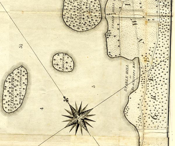 CL152621.jpg 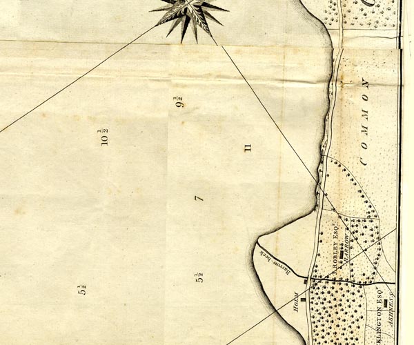 CL152620.jpg 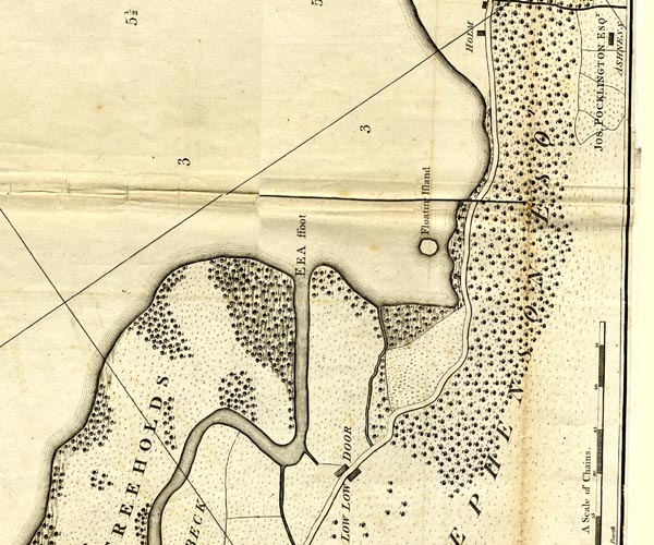 CL152619.jpg 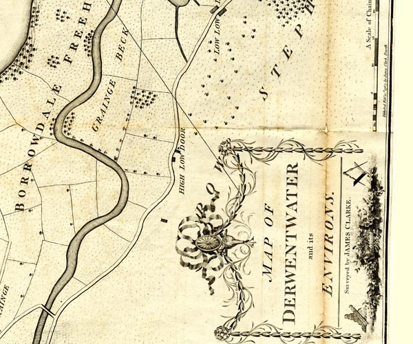 CL152618.jpg item:- private collection : 169 Image © see bottom of page |
||||||||||||||||||||||||||||
|
|
|||||||||||||||||||||||||||||
| evidence:- | old map:- Clarke 1787 map (Der - west side of lake) placename:- |
||||||||||||||||||||||||||||
| source data:- | Map, uncoloured engraving, Map of Derwentwater and its Environs,
scale about 13 ins to 1 mile, by James Clarke, engraved by S J
Neele, published by James Clarke, Penrith, Cumberland and in
London etc, 1787.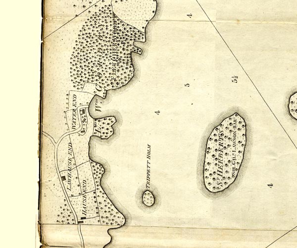 CL152521.jpg 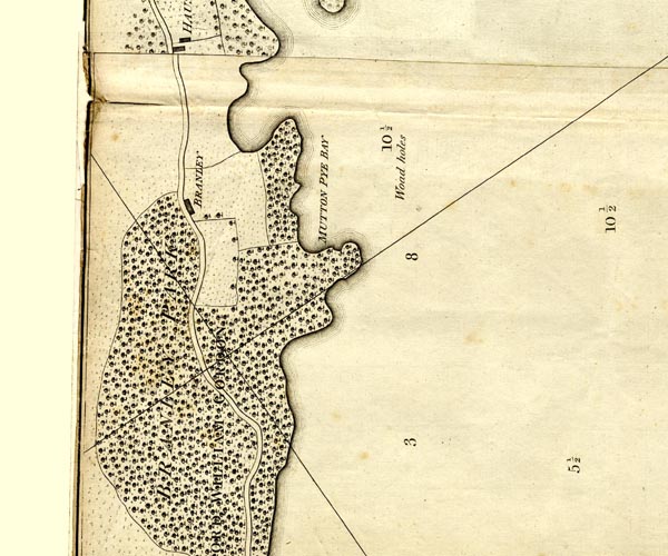 CL152520.jpg 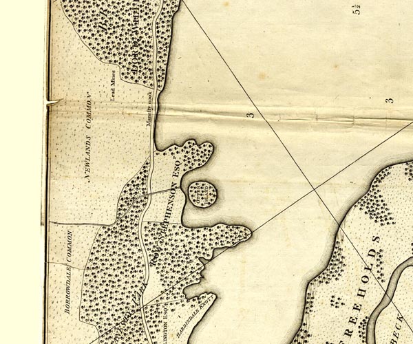 CL152519.jpg 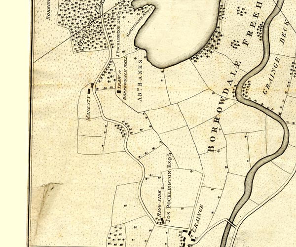 CL152518.jpg road item:- private collection : 169 Image © see bottom of page |
||||||||||||||||||||||||||||
|
|
|||||||||||||||||||||||||||||
| evidence:- | old text:- Clarke 1787 |
||||||||||||||||||||||||||||
| source data:- | Guide book, A Survey of the Lakes of Cumberland, Westmorland,
and Lancashire, written and published by James Clarke, Penrith,
Cumberland, and in London etc, 1787; published 1787-93. goto source Page 75:- "..." "Till within these few years this place [entry to Borrowdale] was scarcely passable for a horse; but now the road quite round this lake is very good, even for carriages, and has been made purposely by the inhabitants for the accommodation of travellers; so that at present a journey into Borrowdale may be performed with both ease and pleasure." "..." goto sourcePage 84:- "..." "Some of the curious who visit this country wish to see Buttermere, Cromark-Water, and Lowes-Water; the road by which they must travel to these lyes up Newlands. I do not admire this journey through roads where a carriage can hardly travel amidst deserts: In many places the traveller cannot even meet with shelter from the storms, which sometimes come on extremely sudden. When I was viewing these places, I was honoured with the most unexpected pop-visit from a thunder-shower I ever experienced; the rain seemed perfectly at home, and as such, came as suddenly, and with as little ceremony, as the shower which Xantippe is said to have discharged upon the head of her patient husband. I had not time to look about me, - the day had been perfectly clear," goto sourcePage 85:- "and I never so much as dreamed of rain till it came perpendicularly upon my head: I attempted to run from it, but in vain, no shelter was near; near indeed must any have been that could have been of the smallest service, for in a few minutes I was completely drenched as if I had been laid to steep: patience, therefore, was my only resource; accordingly, patiently or perhaps obstinately, I sat myself down and bid it defiance. I think I need hardly add, that such an attack might prove too violent for a delicate constitution." |
||||||||||||||||||||||||||||
|
|
|||||||||||||||||||||||||||||
| evidence:- | old map:- Laurie and Whittle 1806 |
||||||||||||||||||||||||||||
| source data:- | Road map, Completion of the Roads to the Lakes, scale about 10
miles to 1 inch, by Nathaniel Coltman? 1806, published by Robert
H Laurie, 53 Fleet Street, London, 1834. click to enlarge click to enlargeLw18.jpg dotted line; 'Cross Roads' item:- private collection : 18.18 Image © see bottom of page |
||||||||||||||||||||||||||||
|
|
|||||||||||||||||||||||||||||
| evidence:- | old text:- Green 1810 |
||||||||||||||||||||||||||||
| source data:- | Set of prints, soft ground etchings, Sixty Studies from Nature,
by William Green, Ambleside, Westmorland, drawn 1808-10,
published 1810. goto source page 70:- "... The views of the valley will likewise give satisfaction, when seen from Rannerdale Knott, a little higher than the top of the old road over it - the new road on the side of this hill does credit to the projectors of it, and renders the access to Buttermere, from Keswick, much easier for carriages than it was formerly." |
||||||||||||||||||||||||||||
|
|
|||||||||||||||||||||||||||||
| evidence:- | old print:- Green 1810 (plate 40) |
||||||||||||||||||||||||||||
| source data:- | Print, soft ground etching, Road between Grange Bridge and Bowder Stone, Borrowdale,
Cumberland, by William Green, Ambleside, Westmorland, 1810.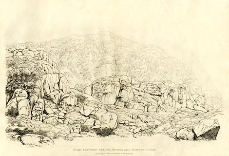 click to enlarge click to enlargeGN1240.jpg Plate 40 in Sixty Studies from Nature, 1810. printed at top right:- "[40]" printed at bottom:- "ROAD BETWEEN GRANGE BRIDGE AND BOWDER STONE. / Drawn and Engraved by William Green, and Published at Ambleside, June 24, 1810." watermark:- "J WHATMAN / 1813" item:- Armitt Library : A6641.40 Image © see bottom of page |
||||||||||||||||||||||||||||
|
|
|||||||||||||||||||||||||||||
| evidence:- | old print:- Green 1810 (plate 41) |
||||||||||||||||||||||||||||
| source data:- | Print, soft ground etching, Borrowdale near Bowder Stone, Borrowdale, Cumberland,
by William Green, Ambleside, Westmorland, 1809.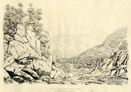 click to enlarge click to enlargeGN1241.jpg Plate 41 in Sixty Studies from Nature, 1810. printed at top right:- "41" printed at bottom:- "BORROWDALE NEAR BOWDER STONE. / Drawn &Engraved by William Green, and Published at Ambleside, Augst. 1, 1809." watermark:- "J WHATMAN / 1813" item:- Armitt Library : A6641.41 Image © see bottom of page |
||||||||||||||||||||||||||||
|
|
|||||||||||||||||||||||||||||
| evidence:- | old text:- Green 1814 |
||||||||||||||||||||||||||||
| source data:- | Set of prints, soft ground etchings, Sixty Small Prints, with
text, A Description of a Series of Sixty Small Prints, by
William Green, Ambleside, Westmorland, 1814. goto source page 20:- "..." "A morning's ride from Keswick, presenting many extraordinary changes, is by passing Lowdore and Bowder Stone to Rosthwaite, and from Rosthwaite by Seat Oller, under Honister Crag in Gatesgarthdale, to Buttermere, and from Buttermere returning through the vale of Newlands to Keswick - a round of about 22 miles." "..." goto sourcepage 21:- "The horse-road to the Inn at Buttermere is eight miles and a half from Keswick, through the vale of Newlands; but the carriage-road is part of the way on the Cockermouth road, over Whinlatter, and through a part of the vale of Lorton, by Crummock Water to the Inn at Buttermere, which is somewhat more than fourteen miles. The Inn at Scale Hill (which is about half a mile from the outlet of Crummock Water and eleven miles from Keswick), and the Inn at Buttermere, are both of them excellent stationary places from which to see ..." |
||||||||||||||||||||||||||||
|
|
|||||||||||||||||||||||||||||
| evidence:- | old print with text:- Farington 1816 |
||||||||||||||||||||||||||||
| source data:- | Print, uncoloured engraving and descriptive text, View on the Road from Keswick to
Borrowdale, Cumberland, drawn by Joseph Farington, engraved by F R Hay, published
by T Cadell and W Davies, Strand, London, 1815.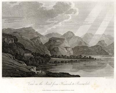 click to enlarge click to enlargeFA0411.jpg printed, bottom left, right, centre "Drawn by J. Farington R.A. / Engraved by F. R. Hay. / View on the Road from Keswick to Borrowdale. / London Published Septr. 15, 1815, by T. Cadell &W. Davies, Strand." Descriptive text:- "VIEW ON THE ROAD FROM KESWICK TO BORROWDALE." "THE road from Keswick to the rocky pass of Borrowdale affords a series of romantic and picturesque views, which cannot fail to impress the imagination of the traveller in an extraordinary manner. Indeed, it is scarcely possible to find a succession of scenes more various and contrasted. The road passes, for some part of the way, through a close lane to a terrace, from which one of the finest views of lake, rock, and mountain scenery is exhibited that can be found in this interesting country. It comprehends the whole of the magnificent masses of rock and hill in the vicinity of the celebrated Waterfall of Lowdore. The peaceful Lake of Derwentwater touches the shore, above which runs the terrace road. The neat villa, called Barrow, embosomed in a grove, appears situated on a gentle elevation, which slopes to the water's edge. The glassy smoothness of the Lake is finely contrasted by rugged crags, and the lofty mountains of Borrowdale, which form a sublime back-ground to the scene represented in our plate." item:- Armitt Library : A6666.11 Image © see bottom of page |
||||||||||||||||||||||||||||
|
|
|||||||||||||||||||||||||||||
| evidence:- | old print:- Farington 1816 |
||||||||||||||||||||||||||||
| source data:- | Print, uncoloured engraving and descriptive text, Castle Crag and Bowder Stone, Borrowdale,
Cumberland, drawn by Joseph Farington, engraved by J Byrne, published by T Cadell
and W Davies, Strand, London, 1815.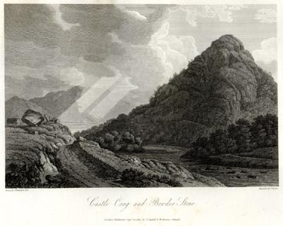 click to enlarge click to enlargeFA0416.jpg printed, bottom left, right, centre "Drawn by J. Farington R.A. / Engraved by J. Byrne. / Castle Crag and Bowder Stone. / London Published Septr. 15, 1815, by T. Cadell &W. Davies, Strand." item:- Armitt Library : A6666.16 Image © see bottom of page |
||||||||||||||||||||||||||||
|
|
|||||||||||||||||||||||||||||
| evidence:- | old print:- Westall 1820 |
||||||||||||||||||||||||||||
| source data:- | Print, uncoloured mezzotint, Keswick Lake, from Barrow Common, Cumberland, drawn and
engraved by William Westall, published by Rodwell and Martin, New Bond Street, London,
1820.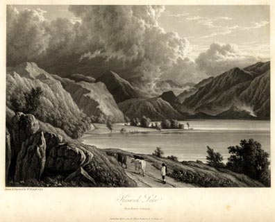 click to enlarge click to enlargeWTL106.jpg printed, bottom left, centre "Drawn & Engraved by W. Westall A.R.A. / Keswick Lake, / from Barrow Common. / Published April 1, 1820, by Hurst, Robinson &Co. Cheapside." item:- Armitt Library : A6671.6 Image © see bottom of page |
||||||||||||||||||||||||||||
|
|
|||||||||||||||||||||||||||||
| evidence:- | descriptive text:- Otley 1823 (5th edn 1834) item:- itinerary; road distances |
||||||||||||||||||||||||||||
| source data:- | Guide book, A Concise Description of the English Lakes, the
mountains in their vicinity, and the roads by which they may be
visited, with remarks on the mineralogy and geology of the
district, by Jonathan Otley, published by the author, Keswick,
Cumberland now Cumbria, by J Richardson, London, and by Arthur
Foster, Kirkby Lonsdale, Cumbria, 1823; published 1823-49,
latterly as the Descriptive Guide to the English Lakes. goto source Page 125:- "KESWICK TO BUTTERMERE." goto source"An excursion through Borrowdale to Buttermere may be made on horseback, taking the road as before described as far as Bowder Stone: a mile beyond which, at Rosthwaite, is a small public-house. A little further, a road on the left leads by Stonethwaite, over the steep mountain pass called the Stake, to Langdale. ..." "At Seatoller, about eight miles from Keswick, a road on the left leads to the black-lead mine, and to Wast Water; and here the Buttermere road, turning to the right, ascends, by the side of a stream broken into pretty waterfalls, up a steep hill; from which there are some fine retrospective views of the upper parts of Borrowdale; and Helvellyn soon begins to shew his head over the mountains of Watendleth. In passing the hause, (which rises 800 feet above the level of Derwent Lake,) Honister Crag in majestic grandeur is presented to the view;" goto sourcePage 126:- "between which and Yew Crag, the road now sharply descends. Both these rocks are famed for producing roofing slate of the best quality; and the edges of the road are beautifully tufted with Alchemilla alpina. Gatesgarth dale, through which the road now goes, (twice crossing and recrossing the stream,) is a narrow valley strewed with large blocks of stone, fallen from the rocks above; and solemnly shaded by the lofty Honister, which towers to the height of 1700 feet above the valley at its foot. We now re-enter upon same soft clay-slate rock, which we parted from at Grange, and the change is soon apparent in the smoothness of the road." "Opposite to the farm of Gatesgarth, which is two miles from the inn at Buttermere, a shepherd's path leads over the mountain, by a pass called Scarf-gap, ... The crags on the left of Scarf-gap are, from their form, called Hay-stacks; and to the right, three adjoining summits are called High-crag, High-stile, and Red-pike. The two first are composed of what some would call a porphyritic greenstone rock, the third of a reddish sienite: and between the second and third lies Burtness Tarn." "The road, after passing Gatesgarth, touches upon the margin of Buttermere Lake, and a little further upon the left is the neat sheltered cottage of Hase-" goto sourcePage 127:- "[Hase]ness. From Keswick to the inn at Buttermere by this route is 14 miles." goto sourcePage 134:- "... the carriage road from Scale Hill; along which there is a pleasant view of the vale of Lorton; and also a fine view of the vale of Keswick in descending the hill from Whinlatter. ..."
|
||||||||||||||||||||||||||||
|
|
|||||||||||||||||||||||||||||
| evidence:- | descriptive text:- Ford 1839 (3rd edn 1843) |
||||||||||||||||||||||||||||
| source data:- | Guide book, A Description of Scenery in the Lake District, by
Rev William Ford, published by Charles Thurnam, Carlisle, by W
Edwards, 12 Ave Maria Lane, Charles Tilt, Fleet Street, William
Smith, 113 Fleet Street, London, by Currie and Bowman,
Newcastle, by Bancks and Co, Manchester, by Oliver and Boyd,
Edinburgh, and by Sinclair, Dumfries, 1839. goto source Page 167:- "..." "XI. KESWICK TO BORRODALE, RETURNING BY WATENDLATH.- 14 M."
|
||||||||||||||||||||||||||||
|
|
|||||||||||||||||||||||||||||
| evidence:- | old print:- Pyne 1853 |
||||||||||||||||||||||||||||
| source data:- | Print, tinted lithograph, The Derwent River and Borrowdale, Cumberland, by James Baker
Pyne, engraved by W Gauci, published by Thomas Agnew and Sons, Manchester, Lancashire,
1853.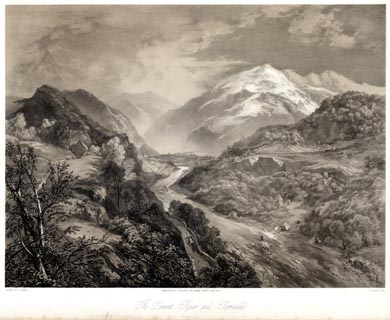 click to enlarge click to enlargePYN224.jpg "PAINTED BY J. B. PYNE. / W. GAUCI LITH. / MANCHESTER, PUBLISHED BY THOMAS AGNEW & SONS, 1853. / The Derwent River and Borrowdale / [ ]" item:- Armitt Library : A6678.25 Image © see bottom of page |
||||||||||||||||||||||||||||
|
|
|||||||||||||||||||||||||||||
| evidence:- | old print:- Pyne 1853 |
||||||||||||||||||||||||||||
| source data:- | Print, coloured lithograph, The Derwent River and Borrowdale, Cumberland, by James
Baker Pyne, engraved by W Gauci, published by Thomas Agnew and Sons, Manchester, Lancashire,
1853.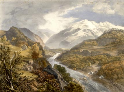 click to enlarge click to enlargePYN424.jpg item:- Armitt Library : A6677.25 Image © see bottom of page |
||||||||||||||||||||||||||||
|
|
|||||||||||||||||||||||||||||
| evidence:- | old text:- Martineau 1855 |
||||||||||||||||||||||||||||
| source data:- | Guide book, A Complete Guide to the English Lakes, by Harriet
Martineau, published by John Garnett, Windermere, Westmorland,
and by Whittaker and Co, London, 1855; published 1855-76. goto source Page 82:- "The road from Lodore to Keswick, about three miles, runs between the lake and the Wallabarrow and Falcon Crags. It is a charming walk in all seasons,- sheltered in winter, shady, for the most part, in summer; and in spring and autumn presenting a vast variety of foliage, bursting forth or fading." |
||||||||||||||||||||||||||||
|
|
|||||||||||||||||||||||||||||
| evidence:- | gradient diagram:- Gall and Inglis 1890s-1900s (Roads) |
||||||||||||||||||||||||||||
| source data:- | Contour Road Book of England, Northern Division, by Harry R G Inglis, published by
Gall and Inglis, 25 Paternoster Square, London and Edinburgh, 1898.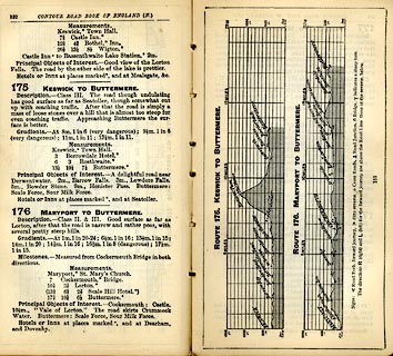 click to enlarge click to enlargeIG5175.jpg Itinerary, with gradient diagram, route 175, Keswick to Buttermere, and route 176, Maryport to Buttermere, Cumberland, 1898. item:- JandMN : 763.13 Image © see bottom of page |
||||||||||||||||||||||||||||
|
|
|||||||||||||||||||||||||||||
| evidence:- | old print:- Bradley 1901 |
||||||||||||||||||||||||||||
| source data:- | Print, uncoloured lithograph, On the Way to the Lake, Keswick, Cumberland, by Joseph
Pennell, published by Macmillan and Co, London, 1901.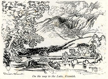 click to enlarge click to enlargeBRL113.jpg On page 76 of Highways and Byways in the Lake District, by A G Bradley. printed at lower left:- "Joseph Pennell" printed at bottom:- "On the Way to the Lake, Keswick." item:- JandMN : 464.13 Image © see bottom of page |
||||||||||||||||||||||||||||
|
|
|||||||||||||||||||||||||||||
| evidence:- | old strip map:- CTC 1911 (Roads) |
||||||||||||||||||||||||||||
| source data:- | Page 110 of Cyclists' Touring Club British Road Book new series vol.6, edited by F
B Sandford, published by Thomas Nelson and Sons, London etc, 1911.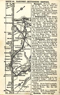 click to enlarge click to enlargeCTC2B0.jpg Strip road map, route 56, Maryport Buttermere Keswick, scale roughly 5 miles to 1 inch. Together with an itinerary and gradient diagram. item:- JandMN : 491.110 Image © see bottom of page |
||||||||||||||||||||||||||||
|
|
|||||||||||||||||||||||||||||
| evidence:- | gradient diagram:- Watson 1912 |
||||||||||||||||||||||||||||
| source data:- | Gradient diagram, black and white halftone, roads from Keswick, Cumberland, in a guide
book, Keswick on Derwentwater, published by George Watson, after 1913.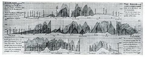 click to enlarge click to enlargeWT4Gd.jpg item:- Keswick Museum : 2145.5 Image © see bottom of page |
||||||||||||||||||||||||||||
|
|
|||||||||||||||||||||||||||||
| evidence:- | old strip map:- Geographia 1925 |
||||||||||||||||||||||||||||
| source data:- | Road book, with road strip maps and gradient diagrams, Premier Road Book of Great
Britain, by Alexander Gross and F Waite-Browne, published by Geographia, 55 Fleet
Street, London, about 1925?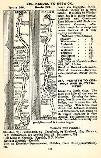 click to enlarge click to enlargeGE1101.jpg "247. - PENRITH TO KESWICK AND BUTTERMERE." item:- Hampshire Museums : B1990.161.4 Image © see bottom of page |
||||||||||||||||||||||||||||
|
|
|||||||||||||||||||||||||||||
| evidence:- | old print:- |
||||||||||||||||||||||||||||
| source data:- | Print, uncoloured engraving, Borrowdale from near the Bowder Stone, Cumberland, drawn
by T Aspland, engraved by W Banks, Edinburgh, published by J Garnett, Windermere,
Westmorland, 1850s-60s?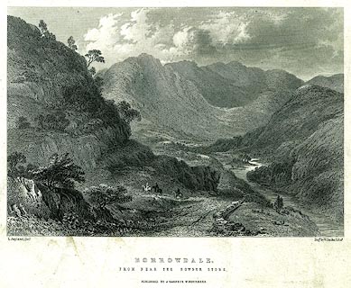 click to enlarge click to enlargePR0224.jpg printed at bottom left, right, centre:- "T. Aspland. Delt. / Engd. by W. Banks, Edinr. / BORROWDALE. / FROM NEAR THE BOWDER STONE. / PUBLISHED BY J. GARNETT, WINDERMERE." item:- Dove Cottage : 2008.107.224 Image © see bottom of page |
||||||||||||||||||||||||||||
|
|
|||||||||||||||||||||||||||||
| evidence:- | outline view:- Black 1856 placename:- Road to Scale Hill |
||||||||||||||||||||||||||||
| source data:- | Print, lithograph, Outline Views, Buttermere - Mountains as seen from the Knots near
the Hotel at Buttermere, and Mountains as seen at the Seat in Lanthwaite Wood, Scale
Hill, by J Flintoft, Keswick, Cumberland, engraved by R Mason, Edinburgh, Lothian,
about 1900. click to enlarge click to enlargeBC08E5.jpg "... Road to Scale Hill ..." item:- JandMN : 37.19 Image © see bottom of page |
||||||||||||||||||||||||||||
|
|
|||||||||||||||||||||||||||||
| evidence:- | outline view:- Black 1841 (3rd edn 1846) placename:- Road to Scale Hill |
||||||||||||||||||||||||||||
| source data:- | Print, engraving, outline view, Mountains as seen from The Knots near the Victoria
at Buttermere, and Mountains as seen at the Seat in Lanthwaite Wood, Scale Hill, by
J Flintoft, Keswick, Cumberland, engraved by R Mason, Edinburgh, Lothian, about 1846.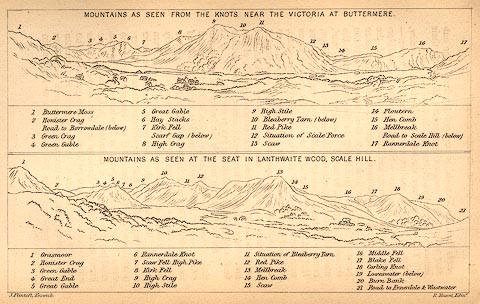 click to enlarge click to enlargeBC02E7.jpg "... Road to Scale Hill ..." item:- JandMN : 32.11 Image © see bottom of page |
||||||||||||||||||||||||||||
|
|
|||||||||||||||||||||||||||||
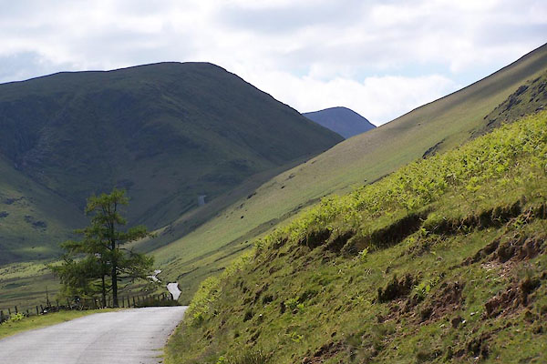
| MN photo:- |
Route via Honister Pass. |
||||||||||||||||||||||||||||
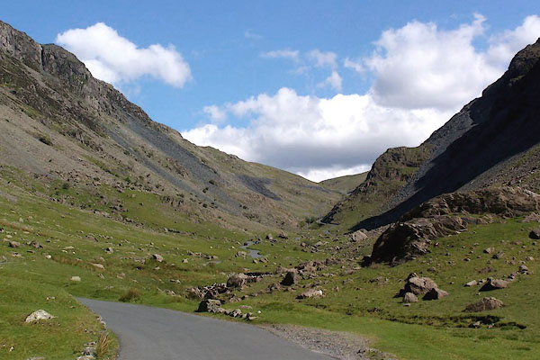 BJQ21.jpg Looking up Honister Pass from the Buttermere side. (taken 10.6.2005) 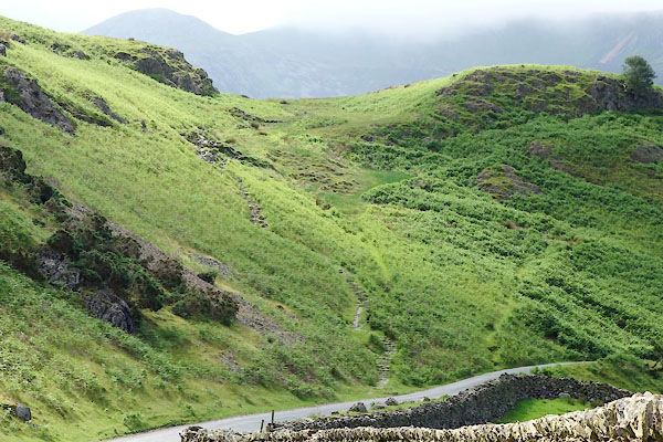 CAY04.jpg Buttermere Hause, the zigzag path starting right of centre is the old road, the new road goes round the point. (taken 11.6.2014) |
|||||||||||||||||||||||||||||
|
|
|||||||||||||||||||||||||||||
| MN photo:- |
Route via Newlands Hause |
||||||||||||||||||||||||||||
 BJQ07.jpg Looking up towards Newlands Hause. (taken 10.6.2005) 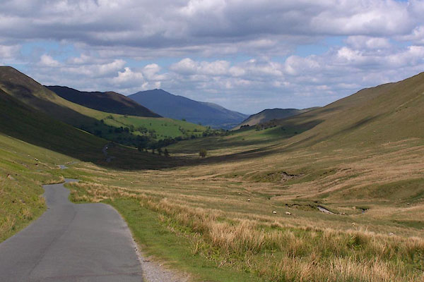 BJQ09.jpg Looking NE from Newlands Hause. (taken 10.6.2005)  BLM49.jpg Looking down Newlands Hause towards Buttermere, from the path up Knott Rigg. (taken 25.12.2005) |
|||||||||||||||||||||||||||||
|
|
|||||||||||||||||||||||||||||
| places:- | Keswick Grange, Borrowdale Rosthwaite, Borrowdale Seatoller, Borrowdale Honister Pass, Buttermere Buttermere High Lorton, Lorton Cockermouth |
||||||||||||||||||||||||||||
|
|
|||||||||||||||||||||||||||||
| places:- | Keswick Keskadale Farm, Above Derwent Newlands, Above Derwent Newlands Hause, Buttermere Buttermere |
||||||||||||||||||||||||||||
|
|
|||||||||||||||||||||||||||||
Lakes Guides menu.