 Old Cumbria Gazetteer
 |
 |
|
| Newlands Hause, Buttermere | ||
| Newlands Hause | ||
| civil parish:- | Buttermere (formerly Cumberland) | |
| civil parish:- | Above Derwent (formerly Cumberland) | |
| county:- | Cumbria | |
| locality type:- | pass | |
| coordinates:- | NY19281761 | |
| 1Km square:- | NY1917 | |
| 10Km square:- | NY11 | |
|
|
||
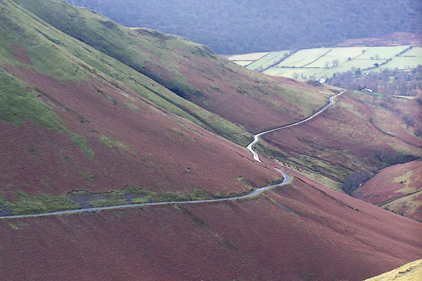 BLM49.jpg Looking down Newlands Hause towards Buttermere, from the path up knott Rigg. (taken 25.12.2005) |
||
|
|
||
| evidence:- | old map:- OS County Series (Cmd 69 3) placename:- Newlands Hause |
|
| source data:- | Maps, County Series maps of Great Britain, scales 6 and 25
inches to 1 mile, published by the Ordnance Survey, Southampton,
Hampshire, from about 1863 to 1948. |
|
|
|
||
| evidence:- | outline view:- Otley 1823 (5th edn 1834) |
|
| source data:- | Print, woodcut outline view, The Mountains South West of
Derwentwater, by Jonathan Otley, Keswick, Cumberland, 1830.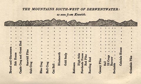 click to enlarge click to enlargeOT2E04.jpg Printed on p.21 of A Concise Description of the English Lakes, by Jonathan Otley, 5th edition, 1834. "THE MOUNTAINS SOUTH-WEST OF DERWENTWATER: as seen from Keswick" "Brund and Glaramara / Esk Hause / Castle Crag and Great End / Scawfell Pike / Gait Crag / Blea Crag / Bull Crag / Cat Bell / Hindscarth / Gold Scalp / Robinson / High Stile / Newlands Hause / Red Pike / Rawling End / Causey Pike / Sail / Ill Crags / Barrow / Swinside / Coledale Hause / Grisedale Pike" item:- JandMN : 48.5 Image © see bottom of page |
|
|
|
||
| evidence:- | descriptive text:- Otley 1823 (5th edn 1834) |
|
| source data:- | Guide book, A Concise Description of the English Lakes, the
mountains in their vicinity, and the roads by which they may be
visited, with remarks on the mineralogy and geology of the
district, by Jonathan Otley, published by the author, Keswick,
Cumberland now Cumbria, by J Richardson, London, and by Arthur
Foster, Kirkby Lonsdale, Cumbria, 1823; published 1823-49,
latterly as the Descriptive Guide to the English Lakes. goto source goto sourcePage 127:- "On leaving Buttermere we encounter a steep hill; but the road, as well as the mountain side, is much smoother than the ascent from Borrowdale. In about a mile and a half we reach the top of the hause, and suddenly glance upon the further edge of Derwentwater, with the wooded rock of Castlehead, and the mountain Saddleback. The first part of the descent into the vale of Newlands is steep, but the road soon becomes smooth and pleasant. From the foot of Rawling End we gain a beautiful view over Derwent Lake and the vale of Keswick; ..." goto source"... through the vale of Newlands. The road over the hause is very steep, rising to the height of 760 feet in less than a mile and a half; and for a short distance on the other side descending very rapidly: but, with steady horses, it is quite practicable." |
|
|
|
||
| evidence:- | descriptive text:- Ford 1839 (3rd edn 1843) |
|
| source data:- | Guide book, A Description of Scenery in the Lake District, by
Rev William Ford, published by Charles Thurnam, Carlisle, by W
Edwards, 12 Ave Maria Lane, Charles Tilt, Fleet Street, William
Smith, 113 Fleet Street, London, by Currie and Bowman,
Newcastle, by Bancks and Co, Manchester, by Oliver and Boyd,
Edinburgh, and by Sinclair, Dumfries, 1839. goto source Page 92:- "..." "NEWLANDS." "The road through Newlands leaves the chapel of Buttermere, and advances by a very steep and" goto sourcePage 93:- "long ascent between Robinson and Whiteless Hill. These mountains present nothing but endless grassy slopes, which is the characteristic of the scenery all the way till you get down to Keskadale, the first houses in Newlands. ..." goto sourcePage 169:- "..." "The road leads up from the inn by the humble little chapel, between Whiteless and Robinson, diversified by little of scenery, till the traveller approaches Keskadale, whence there is a prospect of the smiling vale of Newlands. ..." |
|
|
|
||
| evidence:- | old text:- Martineau 1855 placename:- Newlands Haws item:- sheep |
|
| source data:- | Guide book, A Complete Guide to the English Lakes, by Harriet
Martineau, published by John Garnett, Windermere, Westmorland,
and by Whittaker and Co, London, 1855; published 1855-76. goto source Page 84:- "... till the road winds in among what the oldest guide-books truly call the solemn pastoral scenes that open after leaving Keskadale. The houses of Keskadale are the last seen before entering on the ascent of Newlands Haws. The vale formed by the rapid slope of mountains that are bare of trees, boggy in parts, and elsewhere showing marks of winter slides, is wholly unlike any thing else in the district. Its silence, except for the bleating of sheep; its ancient folds, down in the hollow, the length and steepness of the ascent, and the gloom of the mountain,- Great Robinson, with its tumbling white cataract,- render this truly "a solemn pastoral scene." At the head of the vale, it is found not to be shut in. A turn to the right discloses a new landscape. A descent between green slopes of the same character leads down directly upon Buttermere. The opposite side of the hollow is formed by the mountain Whitelees. The stream at the bottom flows into Crummock Water; and the four peaks of High Crag, Hayrick, High Stile, and Red Pike, are ranged in front." |
|
|
|
||
| evidence:- | old text:- Martineau 1855 placename:- Buttermere Hawes item:- altitude, Newlands Hause |
|
| source data:- | Guide book, A Complete Guide to the English Lakes, by Harriet
Martineau, published by John Garnett, Windermere, Westmorland,
and by Whittaker and Co, London, 1855; published 1855-76. goto source Page 179:- "PASSES." ": : Height above the Level of the Sea" "Buttermere Hawes, Newlands : Cumberland : 1160" |
|
|
|
||
| evidence:- | old print:- Harwood 1842 placename:- Buttermere Hawse |
|
| source data:- | Print, uncoloured engraving, Buttermere Hawse, Cumberland, engraved and published
by John Harwood, 26 Fenchurch Street, London, 1846.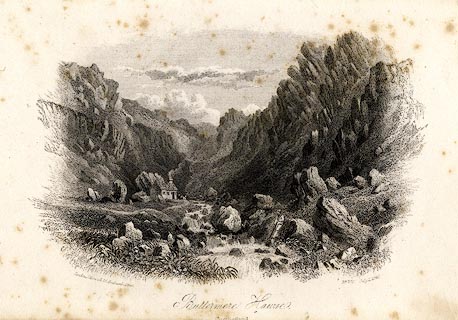 click to enlarge click to enlargeHRW218.jpg printed at bottom left, right, centre:- "London, J. Harwood, 26, Fenchurch Street. / No.700 July 1, 1846. / Buttermere Hawse. / Cumberland." item:- JandMN : 166.18 Image © see bottom of page |
|
|
|
||
Lakes Guides menu.