 Old Cumbria Gazetteer
 |
 |
|
| Ravenglass Harbour, Ravenglass | ||
| Ravenglass Harbour | ||
| site name:- | Esk, River (2) | |
| site name:- | Mite, River | |
| site name:- | Irt, River | |
| locality:- | Ravenglass | |
| civil parish:- | Muncaster (formerly Cumberland) | |
| civil parish:- | Bootle (formerly Cumberland) | |
| civil parish:- | Drigg and Carleton (formerly Cumberland) | |
| county:- | Cumbria | |
| locality type:- | harbour | |
| coordinates:- | SD08159602 (etc) | |
| 1Km square:- | NY0896 | |
| 10Km square:- | SD09 | |
|
|
||
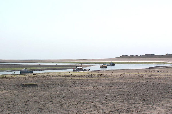 BMC08.jpg The Esk. (taken 11.5.2006) 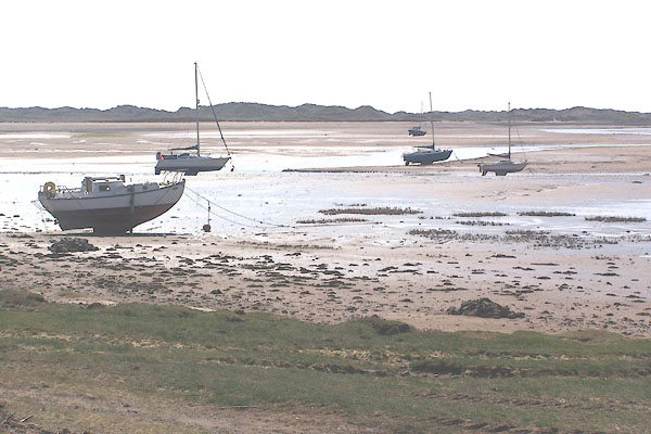 BMC04.jpg The Mite. (taken 11.5.2006) |
||
|
|
||
| evidence:- | old text:- Gents Mag item:- perch; sea mark; harbour light |
|
| source data:- | Magazine, The Gentleman's Magazine or Monthly Intelligencer or
Historical Chronicle, published by Edward Cave under the
pseudonym Sylvanus Urban, and by other publishers, London,
monthly from 1731 to 1922. goto source goto sourceGentleman's Magazine 1748 p.292 "..." "The Perch is a word us'd here for the mouth of a harbour; there is a long pole rais'd in the middle of the channel of Ravenglass harbour for a post of direction; to such as these candles and lanthorns are affix'd, for night guides in most places." "This harbour is extremely ill represented on all maps; certainly no geographer has ever inspected it: Three tolerable streams empty themselves into it, whose names and course you have in the draught." |
|
|
|
||
| evidence:- | old map:- Donald 1774 (Cmd) |
|
| source data:- | Map, hand coloured engraving, 3x2 sheets, The County of Cumberland, scale about 1
inch to 1 mile, by Thomas Donald, engraved and published by Joseph Hodskinson, 29
Arundel Street, Strand, London, 1774.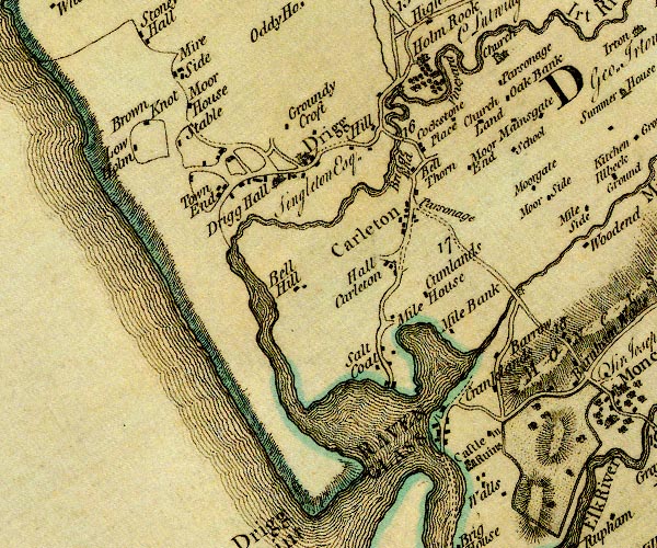 D4SD09NE.jpg item:- Carlisle Library : Map 2 Image © Carlisle Library |
|
|
|
||
| evidence:- | old text:- Mackenzie 1776 placename:- Ravinglas Harbour item:- buoy; fish weir |
|
| source data:- | Charts, and sailing directions, Nautical Descriptions of the
West Coast of Great Britain, Bristol Channel to Cape Wrath, by
Murdoch Mackenzie, published London, 1776. goto source Page 19:- "RAVINGLAS Harbour." "Ravinglas is a dry Harbour in Cumberland, where three rivulets, Esk, Mite, and Ort, unite. There is a buoy placed a little within the mouth of the Channel, in the middle near a fish-ware, which marks the entry. At this buoy, and in most of the Channel, the depth is three fathoms at high-water with neap-tide. The best part for vessels to lie aground on, is half a cable's-length from the W. end of the town of Ravinglas, on the S. side of a perch, which stands on the point of the sand there. At this anchorage, in the mouth of the River Esk, and also at the confluence of the two other rivers, there are three fathoms at high-water with spring-tide, and ten feet with neaps." "To sail into Ravinglas. / To sail into Ravinglas Harbour; take four hours of flood, keep above a mile from the coast (to avoid Selker and Drig Rocks) till Ravinglas town bears E.N.E. steer in that course till you see the buoy bearing E. and then steer right for it, keeping within a ship's-length of it on either hand: when you are just past the buoy, steer E.N.E. or keep Ravinglas a sail's-breadth open to the N. of your stern, till you are about half a mile from the E. end of the sandy hillocks; hook the small bay, which begins there; keep near a cable's-length from the point at the end of that small bay, and anchor half a cable's-length from the W. end of the town, or off the perch, in the meeting of the three rivers. When the buoy in the entry bears E. it is also in a line with the S. shoulder of Newton-knot Hill, which is a small hill, half a mile S. of Ravinglas, on which some corn fields and furz-bushes may be seen." |
|
|
|
||
| evidence:- | old text:- Capper 1808 |
|
| source data:- | Gazetteer, A Topographical Dictionary of the United Kingdom,
compiled by Benjamin Pitts Capper, published by Richard
Phillips, Bridge Street, Blackfriars, London, 1808; published
1808-29. goto source "[Ravenglass] ... situated at the mouths of the rivers Irt and Eske, where they unite and form a harbour near the Irish Sea, ......" |
|
|
|
||
| evidence:- | old text:- Admiralty 1933 placename:- Ravenglass Harbour item:- leading line; sea mark |
|
| source data:- | goto source Page 384:- "..." "Ravenglass harbour. - Ravenglass harbour is formed by the drying estuary into which the rivers Esk, Mite, and Irt discharge," goto sourcePage 385:- "about 3 miles northward of Tarn point; the channel through the estuary is narrow, winding, and liable to change. Sands and scars, which dry from 4 to 14 feet (1m2 to 4m3), extend nearly one mile seaward of the entrance." "..." "The entrance may be readily identified by the sandhills bounding it, which continue northward to within a mile of Seascale, an elevation of 111 feet (33m8) situated near the coast about 3 3/4 miles northward of Drigg point (Lat. 54~ 21' N., Long. 3~ 26' W.), the northern point of the entrance; the long sloping hill of Newtown Knott, south-eastward of Ravenglass, on which is a tall pillar, also helps to identify it." "On a nearer approach a second pillar, known as The Sea Mark, will be sighted; it stands near the coastline on the southern side of the entrance, and, in line with Newtown Knott pillar, bearing 065~, leads into the entrance channel. See view on chart 1826." "There are depths of 18 feet (5m5) at high water springs on the line of the leading marks, and, farther in, there are depths of about 2 feet (0m6) less as far as Ravenglass. Coasting craft of not more than 11-foot (3m4) draught enter the harbour, occasionally, and lie aground." "Local knowledge is necessary for entering the harbour." "Vessels awaiting a favourable tide may anchor offshore, in favourable weather, in depths of 8 fathoms (14m6), sand and shell." "When approaching the harbour, keep outside the distance of 2 miles from the coast until the leading marks are on. Then steer in, keeping the leading marks in line, bearing 065~, until within about 3 cables of The Sea Mark, when the village, off which vessels beach, must be steered for." |
|
|
|
||
Lakes Guides menu.