 Old Cumbria Gazetteer
 |
 |
|
| Kirkoswald Castle, Kirkoswald | ||
| Kirkoswald Castle | ||
| locality:- | Kirkoswald | |
| civil parish:- | Kirkoswald (formerly Cumberland) | |
| county:- | Cumbria | |
| locality type:- | castle | |
| locality type:- | park (?) | |
| coordinates:- | NY559410 | |
| 1Km square:- | NY5541 | |
| 10Km square:- | NY54 | |
|
|
||
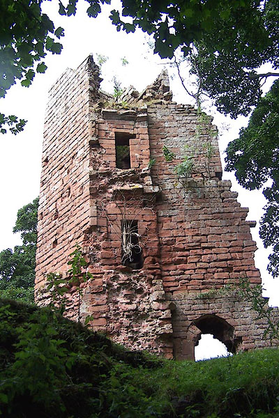 BJU31.jpg The remaining tower at the NE corner of the hall. (taken 26.8.2005) 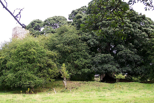 BJU32.jpg Mounds and ditches. (taken 26.8.2005) |
||
|
|
||
| evidence:- | old map:- OS County Series (Cmd 40 6) placename:- Kirkoswald Castle |
|
| source data:- | Maps, County Series maps of Great Britain, scales 6 and 25
inches to 1 mile, published by the Ordnance Survey, Southampton,
Hampshire, from about 1863 to 1948. "Kirkoswald Castle (Remains of) / Tower" |
|
|
|
||
| evidence:- | old map:- Saxton 1579 |
|
| source data:- | Map, hand coloured engraving, Westmorlandiae et Cumberlandiae Comitatus ie Westmorland
and Cumberland, scale about 5 miles to 1 inch, by Christopher Saxton, London, engraved
by Augustinus Ryther, 1576, published 1579-1645.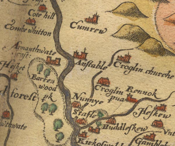 SAX9NY54.jpg circle, two towers; and a ring of fence palings, enclosing trees. item:- private collection : 2 Image © see bottom of page |
|
|
|
||
| evidence:- | probably old map:- Speed 1611 (Cmd) |
|
| source data:- | Map, hand coloured engraving, Cumberland and the Ancient Citie
Carlile Described, scale about 4 miles to 1 inch, by John Speed,
1610, published by J Sudbury and George Humble, Popes Head
Alley, London, 1611-12.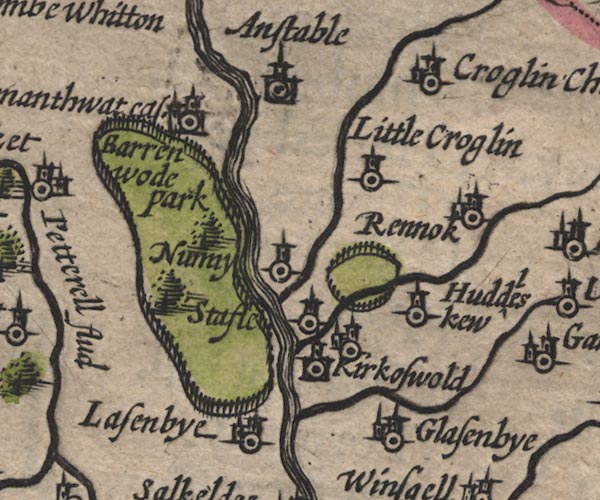 SP11NY54.jpg circle, building, tower and ring of fence palings, N of Kirkoswald item:- private collection : 16 Image © see bottom of page |
|
|
|
||
| evidence:- | old map:- Jansson 1646 placename:- Kirkoswold |
|
| source data:- | Map, hand coloured engraving, Cumbria and Westmoria, ie
Cumberland and Westmorland, scale about 3.5 miles to 1 inch, by
John Jansson, Amsterdam, Netherlands, 1646.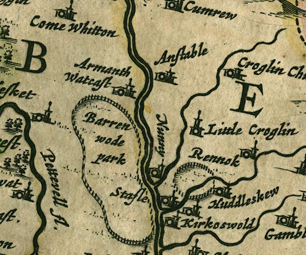 JAN3NY54.jpg "[Kirkoswold]" Buildings and tower, no flag; the label belongs to the village close by; and a ring of fence palings nearby. item:- JandMN : 88 Image © see bottom of page |
|
|
|
||
| evidence:- | old map:- Morden 1695 (Cmd) |
|
| source data:- | Map, uncoloured engraving, Cumberland, scale about 4 miles to 1
inch, by Robert Morden, 1695, published by Abel Swale, the
Unicorn, St Paul's Churchyard, Awnsham, and John Churchill, the
Black Swan, Paternoster Row, London, 1695-1715.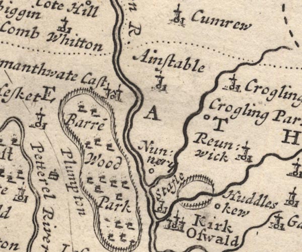 MD12NY54.jpg Ring of fence palings, trees, north of Kirk Oswald. item:- JandMN : 90 Image © see bottom of page |
|
|
|
||
| evidence:- | old print:- Buck 1739 placename:- Kirkoswald Castle item:- sword, Morvill; murder; moat |
|
| source data:- | Print, uncoloured engraving, The North East View of Kirkoswald Castle, in the County
of Cumberland, drawn and engraved by Samuel and Nathaniel Buck, published 1739.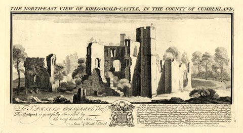 click to enlarge click to enlargeBU0209.jpg printed, top "THE NORTH-EAST VIEW OF KIRKOSWALD-CASTLE, IN THE COUNTY OF CUMBERLAND." printed, bottom "THIS Castle was founded soon after ye Conquest, by Radulph Engaine Lord of Kirkoswald, & afterwds. came by Marriage to Sr. Hugh Morvill, who was one of ye Four Knights that kill'd Thomas Becket, & whose Sword, wherewith he kill'd Him. is said to have been kept here for some time. Next it came, by ye like means, to ye Moltons, and then in ye Reign of K. Edw. III. to ye Dacres, in wch. Family it continu'd for eight Generations, till Ld. Thos. Dacre, who in ye Reign of K. Hen. VIII. moted it about, & after Him for three Generations more, till ye Reign of Q. Eliz. when by Marriage of ye Heiress, it came to ye Family of ye Leonards Els. of Sussex, in wch. it continu'd till ye reign of Q. Anne, when ye last El. of that Name dying without Issue Male, it was expos'd to Sale & purchas'd by Sr. Christoph. Musgrave Bart. Father of Sr. Philip ye present Proprietor. / Saml &Nathl. Buck delin: et Sculp. Publish'd according to Act of Parliamt. March 26. 1739." item:- Armitt Library : 1959.67.9 Image © see bottom of page |
|
|
|
||
| evidence:- | descriptive text:- Simpson 1746 placename:- Kirkoswald Castle |
|
| source data:- | Atlas, three volumes of maps and descriptive text published as
'The Agreeable Historian, or the Compleat English Traveller
...', by Samuel Simpson, 1746. goto source goto source"... Kirkoswald and Dacre Castle, the late Earl of Suffex's. ..." |
|
|
|
||
| evidence:- | old text:- Pennant 1773 |
|
| source data:- | Book, A Tour from Downing to Alston Moor, 1773, by Thomas
Pennant, published by Edward Harding, 98 Pall Mall, London, 1801. goto source Pennant's Tour 1773, page 168 "... the reign of King John, and Hugh de Morville till about the sixth year of that monarch. In the second he obtained a licence to inclose his woods at Kirk-Oswald, to fortify his manor-house, ... A Thomas de Multon enlarged and strengthened the castle; John de Castro, who married his widow, gave it more security, by new works; Thomas Dacre added a large ditch, and beautified it at great expence. A Mr. Sandford, quoted by Dr. Burn, speaks of it as a most capital grand castle, and that it was the fairest fabric that eyes ever looked on; that the hall was an hundred yards long, and on the roof was por-" goto sourcePennant's Tour 1773, page 169 "[por]trayed King Brute and all his successor Kings of England. Very little of this magnificent castle remains; some scanty ruins mark its place. Mr. Sandford speaks of it as standing in the time of the Dacre earl of Sussex, who received his title in 1674." |
|
|
|
||
| evidence:- | old map:- Donald 1774 (Cmd) |
|
| source data:- | Map, hand coloured engraving, 3x2 sheets, The County of Cumberland, scale about 1
inch to 1 mile, by Thomas Donald, engraved and published by Joseph Hodskinson, 29
Arundel Street, Strand, London, 1774.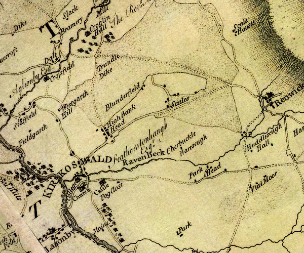 D4NY54SE.jpg "Castle" large building; a castle item:- Carlisle Library : Map 2 Image © Carlisle Library |
|
|
|
||
| evidence:- | old text:- Clarke 1787 placename:- Kirkoswald Castle |
|
| source data:- | Guide book, A Survey of the Lakes of Cumberland, Westmorland,
and Lancashire, written and published by James Clarke, Penrith,
Cumberland, and in London etc, 1787; published 1787-93. goto source Page 105:- "..." "I do not find any ancient authors mention a castle here [Castlerigg], Speed, who speaks of twenty-five in Cumberland, hath found out every one I ever heard or knew of, except Kirkoswald; how that has escaped him I cannot tell. I shall here put down their names, and, as well as I can, their most ancient owners, and supposed founders." "..." goto sourcePage 106:- "..." "26. KIRKOSWALD. Sir Hugh de Morvill." |
|
|
|
||
| evidence:- | old text:- Camden 1789 (Gough Additions) placename:- Kirk Oswald Castle |
|
| source data:- | Book, Britannia, or A Chorographical Description of the Flourishing Kingdoms of England,
Scotland, and Ireland, by William Camden, 1586, translated from the 1607 Latin edition
by Richard Gough, published London, 1789. goto source Page 190:- "..." ""Kirk Oswald castle south south-east 12 miles from Cairluel, and south from Naward, standeth almost on Eden." It was much improved by sir Hugh Morbill, who got the town a market t. John, and finished, and moated by Thomas Dacre, who married the heiress of Greystock; but it is now ruined." "..." ""Northward from Ousby on the river Eden standeth the capital grand castle Kirk Oswald, ..."" "... This great castle of Kirk Oswald was once the fairest fabrick that ever eyes looked upon. The hall I have seen 100 yards long, and the great pourtraiture of king Brute, lying in the end of the roof of this hall, and of all his succeeding successors, kings of England, portraieted to the waist, their visages, hats, feathers, garbs, and habits, in the roof of this hall; now translated to Naward [Castle]" |
|
|
|
||
| evidence:- | old text:- Capper 1808 |
|
| source data:- | Gazetteer, A Topographical Dictionary of the United Kingdom,
compiled by Benjamin Pitts Capper, published by Richard
Phillips, Bridge Street, Blackfriars, London, 1808; published
1808-29. goto source "[Kirkoswald] ... lies on the east side of the river Eden, near which stands the remains of a castle, once a magnificent residence. In the reign of Henry VIII. ..." |
|
|
|
||
| evidence:- | descriptive text:- Ford 1839 (3rd edn 1843) |
|
| source data:- | Guide book, A Description of Scenery in the Lake District, by
Rev William Ford, published by Charles Thurnam, Carlisle, by W
Edwards, 12 Ave Maria Lane, Charles Tilt, Fleet Street, William
Smith, 113 Fleet Street, London, by Currie and Bowman,
Newcastle, by Bancks and Co, Manchester, by Oliver and Boyd,
Edinburgh, and by Sinclair, Dumfries, 1839. goto source Page 29:- "[On the east side of the town,] on high ground, stands the Castle; the ruins are very scanty; the angle of what was once apparently been a high tower, and the ground thrown together in irregular heaps, now grown over with grass, are all that remain. ..." |
|
|
|
||
| evidence:- | old map:- Ford 1839 map |
|
| source data:- | Map, uncoloured engraving, Map of the Lake District of
Cumberland, Westmoreland and Lancashire, scale about 3.5 miles
to 1 inch, published by Charles Thurnam, Carlisle, and by R
Groombridge, 5 Paternoster Row, London, 3rd edn 1843.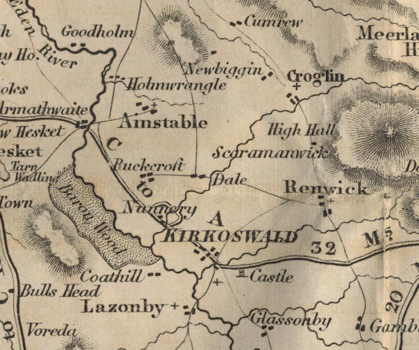 FD02NY54.jpg "Castle" item:- JandMN : 100.1 Image © see bottom of page |
|
|
|
||
| evidence:- | old text:- Gents Mag |
|
| source data:- | Magazine, The Gentleman's Magazine or Monthly Intelligencer or
Historical Chronicle, published by Edward Cave under the
pseudonym Sylvanus Urban, and by other publishers, London,
monthly from 1731 to 1922. goto source Gentleman's Magazine 1839 part 2 p.510 From a review of A Guide to Naworth and Lanercost, by Samuel Jefferson. "..." "The castle of Kirkoswald being dismantled about the year 1604, by Lord Dacre of the South, the ceilings of the hall and chapel, with their curious paintings, were purchased by Lord William [Howard], who applied them to the same uses at Naworth, and the repairs were proceeding when the castle was visited by Camden in 1607." (P.23.)" |
|
|
|
||
| evidence:- | site plan:- Curwen 1913 placename:- Kirkoswald Castle |
|
| source data:- | Site plan, lithograph, Plan of Kirkoswald Castle, Kirkoswald, Cumberland, scale about
1 to 1200, published for the Cumberland and Westmorland Antiquarian and Archaeological
Society by Titus Wilson, Kendal, Westmorland, 1913.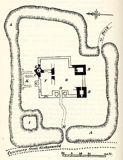 click to enlarge click to enlargeCW0129.jpg On p.152 of The Castles and Fortified Towers of Cumberland, Westmorland, and Lancashire North of the Sands, by John F Curwen. printed at bottom:- "PLAN OF KIRKOSWALD CASTLE." item:- Armitt Library : A782.29 Image © see bottom of page |
|
|
|
||
| evidence:- | database:- Listed Buildings 2010 placename:- Kirkoswald Castle |
|
| source data:- | courtesy of English Heritage "KIRKOSWALD CASTLE / / / KIRKOSWALD / EDEN / CUMBRIA / II / 73491 / NY5594641021" |
|
| source data:- | courtesy of English Heritage "Castle in ruins. Late C15 incorporating earlier buildings for the Dacre family. Large blocks of Penrith red sandstone ashlar on chamfered plinth. Remains of 3 towers and part of the hall, with other foundations below ground level, proved by excavation. 3 storey angle garderobe tower has pointed ground floor entrance and small lancet openings on 2 faces; facing stones have individual mason's marks. Inner wall has various garderobe entrances, one with chamfered lintel. Fragments remain of the adjoining hall walls. One other angle tower stands 2 storeys high with vaulted basement and first floor window, but all facing stone removed above ground level. Vaulted basement of a similar corresponding angle tower remains, but no walls are visible above ground. Encircling moat is early C16 and is complete. Building abandoned in late C16 and demolition began in 1604, with materials taken to Naworth Castle and other stone finding its way into many buildings in Kirkoswald. See, Curwen, Castles and Towers of Cumberland &Westmorland, 1913, p150-153." |
|
|
|
||
| evidence:- | old print:- |
|
| source data:- | Print, uncoloured engraving, Kirkoswald Castle, Cumberland, published by the Illustrated
London News, 12 August 1882.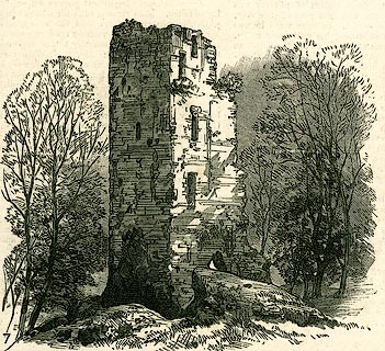 click to enlarge click to enlargePR0317.jpg Illustrations of place visited by the Royal Archaeological Institute. item:- Dove Cottage : 2008.107.317 Image © see bottom of page |
|
|
|
||
| evidence:- | old print:- placename:- Kirkoswald Castle |
|
| source data:- | Print, uncoloured engraving, Kirkoswald Castle, Cumberland, engraved by Metcalf, published
late 18th century?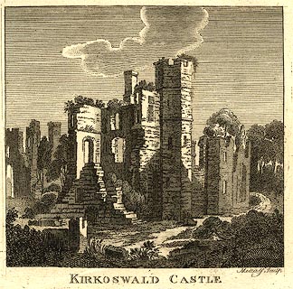 click to enlarge click to enlargePR0284.jpg printed at bottom right, centre:- "Metcalf Sculp / KIRKOSWALD CASTLE" item:- Dove Cottage : 2008.107.284 Image © see bottom of page |
|
|
|
||
| evidence:- | old print:- Buck 1739/1837 (edn 1877) placename:- Kirkoswald Castle |
|
| source data:- | Print, uncoloured engraving, The North East View of Kirkoswald Castle, in the County
of Cumberland, drawn and engraved by Samuel and Nathaniel Buck, 1739, reprinted by
Hudson Scott and Sons, Carlisle, Cumberland, 1877.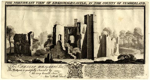 click to enlarge click to enlargeBU0110.jpg With descriptive text of 1837. No.10 in The Castles, Abbeys, and Priories of the County of Cumberland, 1877. printed at top:- "THE NORTH-EAST VIEW OF KIRKOSWALD-CASTLE, IN THE COUNTY OF CUMBERLAND." printed at lower left:- "To Sr: PHILIP Musgrave Bart. This Prospect is gratefully Inscribed by his very humble Servts: Saml. &Nathl. Buck." printed at lower right:- "THIS castle was founded soon after ye Conquest, by Radulph Engaine Lord of Kirkoswald, & afterwds. came by Marriage to Sr. Hugh Morvill, who was one of ye Four Knights that kill'd Thomas Becket, & whose Sword, wherewith he kill'd Him, is said to have been kept here for some time. Next it came, by ye like means, tp ye Moltons, & then in ye Reign of K. Edw. III. to ye Dacres, in wch. Family it continu'd for eight Generations, till Ld. Thomas Dacre. who in ye Reign of K. Hen. VIII. moted it about, & after Him for three Generations more, till ye Reign of Q. Eliz. when by Marriage of ye Heiress, it came to ye Family of ye Leonards Els. of Sussex, in wch. it continu'd till ye Reigh of Q. Anne, when ye last El. of that Name dying without Issue Male, it was expos'd to Sale & purchas'd by Sr. Christoph. Musgrave Bart. & Father of Philip ye present Proprietor. Saml. &Nathl. Buck delin: et sculp: Publish'd according to Act of Parliament March 26. 1739." item:- JandMN : 178.10 Image © see bottom of page |
|
|
|
||
| hearsay:- |
Motte and bailey from 1201; remains of towers and moat, etc. Built soon after the
Conquest; attacked by Scots inroads, rebuilt, fortified again, etc. |
|
|
|
||
| notes:- |
tower, keep, curtain walls, gateway, all in ruins, within a moat |
|
| Perriam, D R &Robinson, J: 1998: Medieval Fortified Buildings of Cumbria: CWAAS::
ISBN 1 873124 23 6; plan and illustrations |
||
|
|
||
Lakes Guides menu.