 Old Cumbria Gazetteer
 |
 |
|
| Devil's Bridge, Kirkby Lonsdale | ||
| Devil's Bridge | ||
| Kirkby Lonsdale Bridge | ||
| site name:- | Lune, River | |
| Street:- | Bridge Brow | |
| locality:- | Kirkby Lonsdale | |
| civil parish:- | Kirkby Lonsdale (formerly Westmorland) | |
| civil parish:- | Casterton (formerly Westmorland) | |
| county:- | Cumbria | |
| locality type:- | bridge | |
| coordinates:- | SD61557824 | |
| 1Km square:- | SD6178 | |
| 10Km square:- | SD67 | |
|
|
||
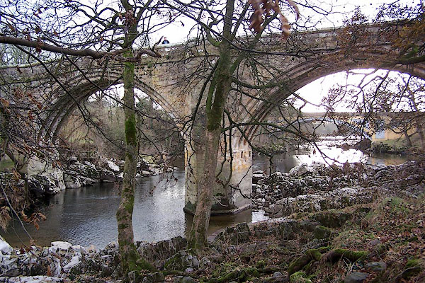 BLL81.jpg (taken 16.12.2005) 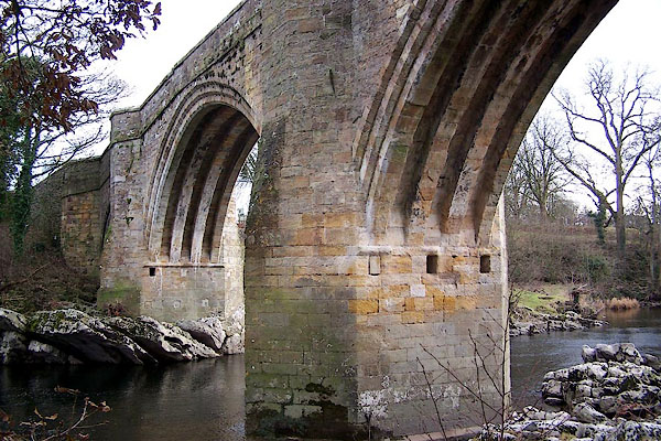 BLL82.jpg (taken 16.12.2005) |
||
|
|
||
| evidence:- | old map:- OS County Series (Wmd 47 12) placename:- Kirkby Lonsdale Bridge |
|
| source data:- | Maps, County Series maps of Great Britain, scales 6 and 25
inches to 1 mile, published by the Ordnance Survey, Southampton,
Hampshire, from about 1863 to 1948. "Kirkby Lonsdale Bridge" |
|
|
|
||
 listed sundial listed sundial |
||
|
|
||
| evidence:- | old map:- Saxton 1579 |
|
| source data:- | Map, hand coloured engraving, Westmorlandiae et Cumberlandiae Comitatus ie Westmorland
and Cumberland, scale about 5 miles to 1 inch, by Christopher Saxton, London, engraved
by Augustinus Ryther, 1576, published 1579-1645.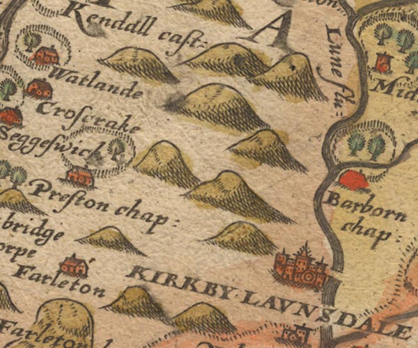 Sax9SD58.jpg At Kirkby Lonsdale; over River Lune. item:- private collection : 2 Image © see bottom of page |
|
|
|
||
| evidence:- | old map:- Keer 1605 |
|
| source data:- | Map, hand coloured engraving, Westmorland and Cumberland, scale
about 16 miles to 1 inch, probably by Pieter van den Keere, or
Peter Keer, about 1605 edition perhaps 1676. click to enlarge click to enlargeKER8.jpg "" double line across a stream; bridge item:- Dove Cottage : 2007.38.110 Image © see bottom of page |
|
|
|
||
| evidence:- | old map:- Speed 1611 (Wmd) |
|
| source data:- | Map, hand coloured engraving, The Countie Westmorland and
Kendale the Cheif Towne, scale about 2.5 miles to 1 inch, by
John Speed, 1610, published by George Humble, Popes Head Alley,
London, 1611-12.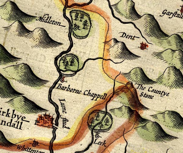 SP14SD68.jpg double line across the Lune item:- Armitt Library : 2008.14.5 Image © see bottom of page |
|
|
|
||
| evidence:- | old map:- Jansson 1646 |
|
| source data:- | Map, hand coloured engraving, Cumbria and Westmoria, ie
Cumberland and Westmorland, scale about 3.5 miles to 1 inch, by
John Jansson, Amsterdam, Netherlands, 1646. JAN3SD67.jpg Double line crossing the stream. item:- JandMN : 88 Image © see bottom of page |
|
|
|
||
| evidence:- | old map:- Seller 1694 (Wmd) |
|
| source data:- | Map, hand coloured engraving, Westmorland, scale about 8 miles
to 1 inch, by John Seller, 1694. click to enlarge click to enlargeSEL7.jpg two lines cross a stream; bridge item:- Dove Cottage : 2007.38.87 Image © see bottom of page |
|
|
|
||
| evidence:- | old map:- Morden 1695 (Wmd) |
|
| source data:- | Map, hand coloured engraving, Westmorland, scale about 2.5 miles to 1 inch, by Robert
Morden, published by Abel Swale, the Unicorn, St Paul's Churchyard, Awnsham, and John
Churchill, the Black Swan, Paternoster Row, London, 1695. MD10SD68.jpg Double line over a stream, over the Lune. item:- JandMN : 24 Image © see bottom of page |
|
|
|
||
| evidence:- | old map:- Badeslade 1742 placename:- |
|
| source data:- | Map, uncoloured engraving, A Map of Westmorland North from
London, scale about 10 miles to 1 inch, with descriptive text,
by Thomas Badeslade, London, engraved and published by William
Henry Toms, Union Court, Holborn, London, 1742. click to enlarge click to enlargeBD12.jpg "" double line across a stream item:- Dove Cottage : 2007.38.62 Image © see bottom of page |
|
|
|
||
| evidence:- | descriptive text:- Simpson 1746 |
|
| source data:- | Atlas, three volumes of maps and descriptive text published as
'The Agreeable Historian, or the Compleat English Traveller
...', by Samuel Simpson, 1746. goto source goto sourcePage 1024:- "..." "Kirkby Lonsdale, ...with a good Stone Bridge over the River Lone. ..." |
|
|
|
||
| evidence:- | old text:- Gents Mag |
|
| source data:- | Print, uncoloured engraving, View of the Bridge over the Lone,
ie Devil's Bridge, Kirkby Lonsdale, Westmorland, published by
the Gentleman's Magazine, 1753. goto source Gentleman's Magazine 1753 opp p.357 Print, uncoloured engraving, View of the Bridge over the Lone, ie Devil's Bridge, Kirkby Lonsdale, Westmorland, published by the Gentleman's Magazine, 1753. 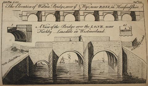 click to enlarge click to enlargePR0754.jpg "A View of the Bridge over the LONE, near / Kirkby Lonsdale in Westmorland." Size: wxh: 21x12cm. item:- Armitt Library : Gents Mag 1753.1 Image © see bottom of page |
|
|
|
||
| evidence:- | old text:- Gents Mag 1753 |
|
| source data:- | goto source Gentleman's Magazine 1753 p.355 "Mr URBAN," "HAving lately had an opportunity of viewing the bridge at Willington, over the river Lone, near Kirkby Lonsdale, which for its antiquity and excellent workmanship exceeds any in the N. of England, and as it may add a little to your history of bridges, I thought it would not be unacceptable. It is the opinion of some judicious persons that this bridge has been a work of the Romans, but I rather think it to be of later date. 'Tis all built of a fine free stone, truly squared, and almost all of a size, the joints are so firm and even that in some places they are hardly to be discovered, and the arches are really admirable. Whatever we moderns may think of ourselves, or whatever mean ideas we may have of these dark ages, here is both strength and beauty." "The arches are all turned with mouldings at the edges, and 3 gutters in the middle, near 8 inches square, as is partly shewn at B, but to give a plainer idea of it, at A is a section of the arch, supposed to be cut in the middle." "To be short, the whole design hath been executed with the utmost exactness both for strenth and beauty. The water under the arch at C, is five yards deep in summer, when the river is very low, and in winter 'tis almost as deep again, and vastly rapid. (See the Plate.)" "Yours, &c. S. PARROT." Willington is probably Whittington, a nearby parish in Lancashire |
|
|
|
||
| evidence:- | old map:- Bowen and Kitchin 1760 |
|
| source data:- | Map, hand coloured engraving, A New Map of the Counties of
Cumberland and Westmoreland Divided into their Respective Wards,
scale about 4 miles to 1 inch, by Emanuel Bowen and Thomas
Kitchin et al, published by T Bowles, Robert Sayer, and John
Bowles, London, 1760. BO18SD58.jpg road across the Lune item:- Armitt Library : 2008.14.10 Image © see bottom of page |
|
|
|
||
| evidence:- | old map:- Jefferys 1770 (Wmd) |
|
| source data:- | Map, 4 sheets, The County of Westmoreland, scale 1 inch to 1
mile, surveyed 1768, and engraved and published by Thomas
Jefferys, London, 1770.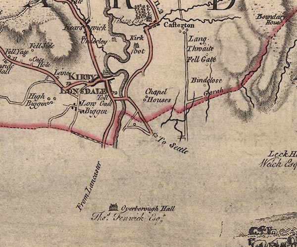 J5SD67NW.jpg double line, road, across a stream; bridge item:- National Library of Scotland : EME.s.47 Image © National Library of Scotland |
|
|
|
||
| evidence:- | old text:- Pennant 1773 item:- giant's pot; churn pot; drowning |
|
| source data:- | Book, A Tour from Downing to Alston Moor, 1773, by Thomas
Pennant, published by Edward Harding, 98 Pall Mall, London, 1801. goto source Pennant's Tour 1773, page 117 "..." "... Here I crossed the river over a lofty bridge of three beautiful elliptical arches, founded on the rocky bottom of the channel. the banks of which are steep and prettily fringed with trees. Below the bridge was formerly a whirlpool, formed by a" goto sourcePennant's Tour 1773, page 118 "giant's pot, or great circular hole in the rock, but at present filled with gravel brought by the floods. Within memory, two young men, excellent swimmers, were drowned here, unable to get out of the vortex." |
|
|
|
||
| evidence:- | descriptive text:- West 1778 (11th edn 1821) |
|
| source data:- | Guide book, A Guide to the Lakes, by Thomas West, published by
William Pennington, Kendal, Cumbria once Westmorland, and in
London, 1778 to 1821. goto source Tour to the Caves in the West Riding of Yorkshire, late 18th century Page 241:- "..." "After breakfast, we walked by the side of the river to the bridge. The channel is deep, the stream rapid, among rocks, the banks on each side covered with trees of various foliage, which serve both as a defence and ornament. The bridge is the most lofty, strong, ancient, and striking to the eye of a stranger, of any I have yet seen. It is built of freestone, has three arches (two large and one smaller) the height from the surface of the water to the top of the centre arch, except in a flood, is about twelve yards. The arches are of the ribbed sort, which makes the appearance the more grotesque. There is no memorial of its foundation - a negative argument of its vast antiquity. We were indeed amused with one anecdote of its founder, which seemed to be a remnant of the ancient mythology of the north, and one instance, among many, of easily accounting for any thing that is marvellous. The country people have a tradition that it was" goto sourcePage 242:- "built by the Devil one night in windy weather; he had but one apron full of stones for the purpose, and unfortunately his apron-string breaking as he flew with them over Casterton-fell, he lost many of them out, or the bridge would have been much higher." "From the top of the bridge the prospect down the river is delightful: ..." |
|
|
|
||
| evidence:- | old text:- Camden 1789 (Gough Additions) |
|
| source data:- | Book, Britannia, or A Chorographical Description of the Flourishing Kingdoms of England,
Scotland, and Ireland, by William Camden, 1586, translated from the 1607 Latin edition
by Richard Gough, published London, 1789. goto source Page 162:- "..." "... The bridge over the river is built of freestone of three ribbed arches, the centre arch is 12 yards from the water." |
|
|
|
||
| evidence:- | old map:- Cary 1789 (edn 1805) |
|
| source data:- | Map, uncoloured engraving, Westmoreland, scale about 2.5 miles
to 1 inch, by John Cary, London, 1789; edition 1805.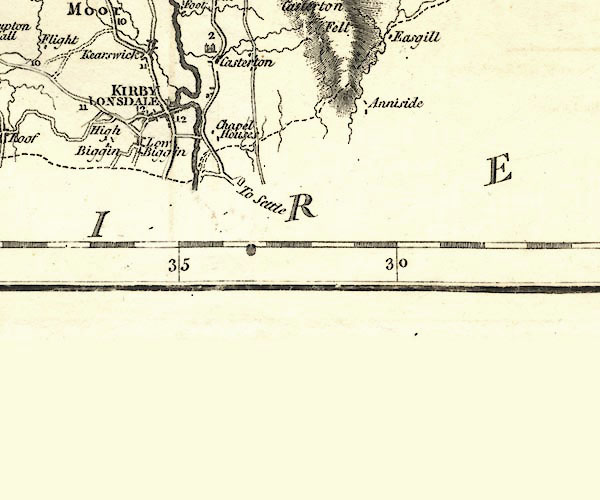 CY24SD67.jpg road across a stream; bridge over the Lune item:- JandMN : 129 Image © see bottom of page |
|
|
|
||
| evidence:- | old map:- Cooper 1808 |
|
| source data:- | Map, hand coloured engraving, Westmoreland ie Westmorland, scale
about 9 miles to 1 inch, by H Cooper, 1808, published by R
Phillips, Bridge Street, Blackfriars, London, 1808. click to enlarge click to enlargeCOP4.jpg road across stream; bridge? item:- Dove Cottage : 2007.38.53 Image © see bottom of page |
|
|
|
||
| evidence:- | old print:- Otley 1823 (8th edn 1849) placename:- Kirkby Lonsdale Bridge |
|
| source data:- | Print, engraving, Kirkby Lonsdale Bridge, North View, ie Devil's Bridge, drawn by
T Binns, Halifax, engraved by O Jewitt, Headington, Oxfordshire, published by Jonathan
Otley, Keswick, Cumberland et al, 1849.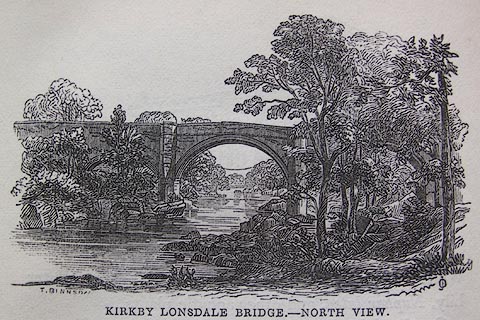 click to enlarge click to enlargeO80E33.jpg On p.178 of A Descriptive Guide of the English Lakes, by Jonathan Otley, 8th edition, 1849. "KIRKBY LONSDALE BRIDGE.- NORTH VIEW." item:- Armitt Library : A1180.31 Image © see bottom of page |
|
|
|
||
| evidence:- | descriptive text:- Otley 1823 (8th edn 1849) placename:- Kirkby Lonsdale Bridge placename:- Lonsdale Bridge |
|
| source data:- | Guide book, A Concise Description of the English Lakes, the
mountains in their vicinity, and the roads by which they may be
visited, with remarks on the mineralogy and geology of the
district, by Jonathan Otley, published by the author, Keswick,
Cumberland now Cumbria, by J Richardson, London, and by Arthur
Foster, Kirkby Lonsdale, Cumbria, 1823; published 1823-49,
latterly as the Descriptive Guide to the English Lakes. goto source Page 178:- "A drive of two miles brings us to KIRKBY LONSDALE BRIDGE. The date of this noble structure is lost in obscurity. Its erection has been attributed to supernatural agency. By a native poet, writing in Bentley's Miscellany, the honour is assigned to the famed Magician, Michael Scott. We shall be contented with a humbler version of its origin, extracted from the Lonsdale Magazine:" "" "Still grand, and beautiful, and good," "Has LONSDALE BRIDGE unshaken stood," "And scorned the swollen raging flood," "For many ages;" "Though antiquarians, who have tried" "Some date to find, in vain have pried" "In ancient pages." "" "Then hear what old traditions says:-" "Close by the Lune in former days" "Lived an old maid, queer in all her ways," "In Yorkshire bred;" "Though now forgot what she was named," "For cheating she was always famed," "'Tis truly said." goto sourcePage 179:- "" "She had a cow, a pony too," "When o'er the Lune, upon the brow," "Had passed one night these fav'rites two;" "'Twas dark and rainy;" "Her cow was o'er, she knew her bellow," "Her pony too, poor little fellow," "She heard him whinny." "" "Alack, alack a-day! she cries," "As overflowed her streaming eyes," "When lo! with her to sympathize," "Old Nick apears;" "'Pray now, good woman, don't despair," "But lay aside all anxious care," "And wipe your tears." "" "'To raise a bridge I will agree," "That in the morning you shall see," "But mine for aye the first must be" "That passes over;" "So by these means you'll soon be able" "To bring the pony to his stable," "The cow her clover.'" "" "In vain were sighs and wailings vented," "So she at last appeared contented," "It was a bargain, she consented,-" "For she was Yorkshire;-" "Now home she goes in mighty glee," "Old Satan too, well pleased he," "Went to his work, sir." "" "When Ilus' son surrounded Troy," "With walls that nothing might destroy," "Two gods some time he did employ," "But never paid 'em;" "Here Satan, certain of his prize," "With building made a terrible noise," "So fast he laid on." "" "In short, the morning streaks appear," "The Bridge is built, and Satan there," "When this old lady then drew near," "Her lap-dog with her;" "'Behold the Bridge,' the tempter cries," "'Your cattle too before your eyes," "So hie you thither.'" goto sourcePage 180:- "" "But mark! she well the bargain knew;" "A bun then from her pocket drew," "And shewed it first to little Cue," "Then over threw it;" "Now flew the bun, now ran the dog," "For eager was the mangy rogue," "Nor stood to view it." "" "'Now, crafty sir, the bargain was," "That you should have what first did pass" "Across the Bridge - so now alas!" "The dog's your right;'" "The cheater cheated, struck with shame," "Squinted and grinned, then in a flame" "He vanished quite." "..." "There is no doubt, however, that the Bridge was built previous to the time of Edward I.; as it appears that in the third year of that reign, there was a grant of pontage for its repair. It is built of freestone, and has three ribbed arches, the two larger of the span of 55 feet each, and the smallest of 28 feet. The roadway is 180 feet in length, but so narrow that 'two wheelbarrows tremble when they meet.' In heavy floods, the river rises a height of 15 feet or more. In ordinary seasons the battlements are about 52 feet above the level of the water. The views of the river from the centre are singularly beautiful; it here flows through a rocky channel, narrow, but of a profound depth; and the banks on either side are adorned with fine trees. In the spring of 1841, a drover committed suicide by precipitating himself over the parapet on the north side into the water." "..." |
|
|
|
||
| evidence:- | old print:- Otley 1823 (8th edn 1849) placename:- Devil's Bridge |
|
| source data:- | Print, engraving, Devil's Bridge, Kirkby Lonsdale, drawn by Mr
Binns, Halifax, engraved by Mr Jewitt, Headington, Oxfordshire,
published by Jonathan Otley, Keswick, Cumberland et al, 1849.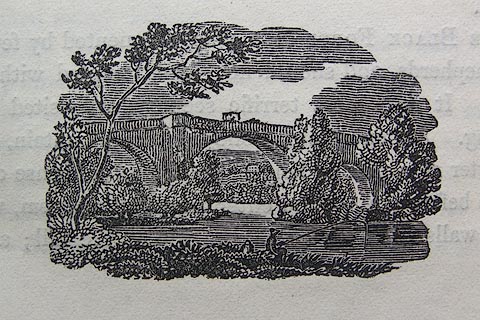 click to enlarge click to enlargeO80E46.jpg On p.190 of A Descriptive Guide of the English Lakes, by Jonathan Otley, 8th edition, 1849. "... let him take a view of the Bridge, from the banks of the river." item:- Armitt Library : A1180.35 Image © see bottom of page |
|
|
|
||
| evidence:- | old print:- Otley 1823 (8th edn 1849) placename:- Devil's Bridge |
|
| source data:- | Print, engraving, Kirkby Lonsdale Bridge - South View, ie Devil's Bridge, drawn by
Mr Binns, Halifax, engraved by Mr Jewitt, Headington, Oxfordshire, published by Jonathan
Otley, Keswick, Cumberland et al, 1849.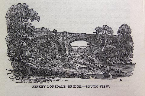 click to enlarge click to enlargeO80E57.jpg On p.212 of A Descriptive Guide of the English Lakes, by Jonathan Otley, 8th edition, 1849. "KIRKBY LONSDALE BRIDGE.- SOUTH VIEW" "T. BINNS [del]" item:- Armitt Library : A1180.42 Image © see bottom of page |
|
|
|
||
| evidence:- | descriptive text:- Otley 1823 (5th edn 1834) |
|
| source data:- | Guide book, A Concise Description of the English Lakes, the
mountains in their vicinity, and the roads by which they may be
visited, with remarks on the mineralogy and geology of the
district, by Jonathan Otley, published by the author, Keswick,
Cumberland now Cumbria, by J Richardson, London, and by Arthur
Foster, Kirkby Lonsdale, Cumbria, 1823; published 1823-49,
latterly as the Descriptive Guide to the English Lakes. goto source Page 41:- "[... the Lune - which at] Kirkby Lonsdale is a fine river, and crossed by a lofty antique bridge; ..." goto sourcePage 93:- "... the ancient bridge at Kirkby Lonsdale, with its picturesque accompaniments of rock, wood, and water - are objects well worthy of notice. ..." |
|
|
|
||
| evidence:- | descriptive text:- Ford 1839 (3rd edn 1843) |
|
| source data:- | Guide book, A Description of Scenery in the Lake District, by
Rev William Ford, published by Charles Thurnam, Carlisle, by W
Edwards, 12 Ave Maria Lane, Charles Tilt, Fleet Street, William
Smith, 113 Fleet Street, London, by Currie and Bowman,
Newcastle, by Bancks and Co, Manchester, by Oliver and Boyd,
Edinburgh, and by Sinclair, Dumfries, 1839. goto source Page 154:- ".." "[Kirkby-Lonsdale] ... The bridge over the Lune is an admirable and remarkable structure, narrow, however, and better suited to the times in which its three ribbed arches were first thrown across the angry and chafing stream below. ..." |
|
|
|
||
| evidence:- | site plan:- Historical Monuments 1936 placename:- Devil's Bridge |
|
| source data:- | Site plan, and elevation, uncoloured lithograph, Kirkby Lonsdale The Devil's Bridge,
Kirkby Lonsdale, Westmorland, scale about 1 to 350, published by Royal Commission
on Historical Monuments England, London, 1936.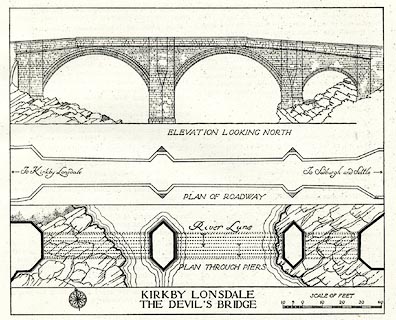 click to enlarge click to enlargeHMW087.jpg On p.137 of the Inventory of the Historical Monuments in Westmorland. printed, lower right "KIRKBY LONSDALE / THE DEVIL'S BRIDGE" RCHME no. Wmd, Kirkby Lonsdale 3 item:- Armitt Library : A745.87 Image © see bottom of page |
|
|
|
||
| evidence:- | database:- Listed Buildings 2010 placename:- Devil's Bridge item:- sundial |
|
| source data:- | courtesy of English Heritage "DEVIL'S BRIDGE / / BRIDGE BROW / KIRKBY LONSDALE / SOUTH LAKELAND / CUMBRIA / I / 75125 / SD6155678235" |
|
| source data:- | courtesy of English Heritage "DEVILS BRIDGE (THAT PART IN CASTERTON CP) / / BRIDGE ROW / CASTERTON / SOUTH LAKELAND / CUMBRIA / I / 75615 / SD6156378234" |
|
| source data:- | courtesy of English Heritage "C15 or early C16. Ashlar and dressed stone. Bridge of three unequal segmental arches, each with four ribs and three chamfers. Two piers with cutwaters which are chamfered back to semi-octagonal refuges at level of roadway. One string. Solid parapet. At Casterton end the remains of sundial, with raised lettering " .. n Constabl C ... Lonsdale War .." "Feare God honer the .. 1673". Once carried the road from Kendal to Skipton, but replaced in 1930s by new bridge 150 m to south. One of finest medieval bridges in England. (RCHM). Scheduled Ancient Monument." |
|
| source data:- | courtesy of English Heritage "Bridge. C15 or early C16. Ashlar and dressed stone. 3 triple-chamfered segmental arches, that to east end smaller; 4 ribs to soffits. Piers have triangular cutwaters to each side, rising to canted refuges; canted abutments. String course with some waterspouts and coped parapet. Roadway approx. 4m across. On north side of south parapet an inscription: "CASTERTON KIRK BY LONSDALE" with arrows. At south side of east end a sundial; a square block on octagonal shaft with 4 fillets, top has roll moulding and octagonal recess. Lettering to front apparently reads: "N : CONSTABL C : LONSDALE WAR"; "FEARE GOD HONER THE : 1673". Carried the Kendal to Skipton road until replaced by Stanley Bridge, 150m to south, in 1930s. One of the finest medieval bridges in England. See RCHM Westmorland. Scheduled Ancient Monument." |
|
|
|
||
| evidence:- | old print:- Johnson c1900 |
|
| source data:- | Print, engraving, Kirkby Lonsdale Bridge, the Devil's Bridge, Kirkby Lonsdale, Westmorland,
by Haworth, published by Thomas Johnson, 30 Church Street, Blackburn, Lancashire,
about 1900.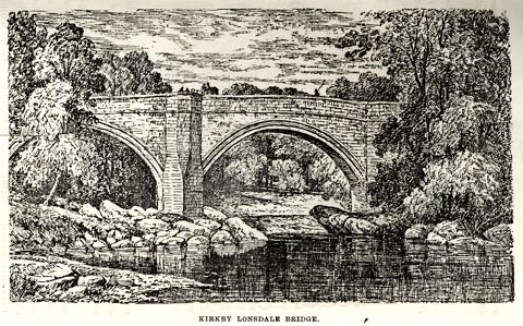 click to enlarge click to enlargeJSN408.jpg On p.16 in The Gossiping Guide to Kirkby Lonsdale. printed at lower left:- "[Haworth]" item:- Armitt Library : A1612.A8 Image © see bottom of page |
|
|
|
||
| evidence:- | old print:- Johnson c1900 |
|
| source data:- | Print, engraving, Devil's Bridge, Kirkby Lonsdale, Westmorland, by RWT, published
by Thomas Johnson, 30 Church Street, Blackburn, Lancashire, about 1900.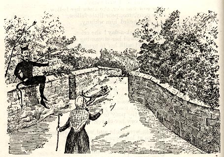 click to enlarge click to enlargeJSN406.jpg On p.16 in The Gossiping Guide to Kirkby Lonsdale. printed at lower left:- "RWT" item:- Armitt Library : A1612.A6 Image © see bottom of page |
|
|
|
||
| evidence:- | old print:- Rumney 1899 placename:- Devil's Bridge |
|
| source data:- | Print, halftone photograph, The Devil's Bridge, Kirkby Lonsdale, Westmorland, published
by George Philip and Son, 32 Fleet Street, London, and Liverpool, 1899.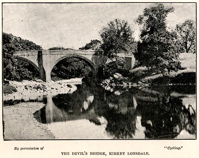 click to enlarge click to enlargeRUM101.jpg Frontispiece to the Cyclist's Guide to the English Lake District, by A W Rumney. printed at bottom:- "By permission of "Cycling." / THE DEVIL'S BRIDGE, KIRKBY LONSDALE." item:- JandMN : 147.2 Image © see bottom of page |
|
|
|
||
| evidence:- | old photograph:- Bogg 1898 placename:- Devil's Bridge |
|
| source data:- | Photograph, halftone print, The Devil's Bridge, Kirkby Lonsdale, Westmorland, by Simpson,
published by Edmund Bogg, 3 Woodhouse Lane, and James Miles, Guildford Street, Leeds,
Yorkshire, 1898.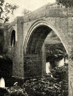 click to enlarge click to enlargeBGG169.jpg Included on p.229 of Lakeland and Ribblesdale, by Edmund Bogg. item:- JandMN : 231.69 Image © see bottom of page |
|
|
|
||
| evidence:- | old print:- Rose 1832-35 placename:- Kirkby Lonsdale Bridge |
|
| source data:- | Print, engraving, Kirkby Lonsdale Bridge, Westmorland, by Thomas Allom, engraved by
S Lacey, 1833.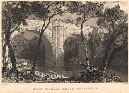 click to enlarge click to enlargeR206.jpg "Kirkby Lonsdale Bridge, Westmorland" item:- JandMN : 96.3 Image © see bottom of page |
|
|
|
||
| evidence:- | old print:- Pennant 1773 (edn 1801) placename:- Kirkby Lonsdale Bridge |
|
| source data:- | Print, engraving, Kirkby Lonsdale Bridge, the Devil's Bridge, Kirby Lonsdale, Westmorland,
published by Edward Harding, 98 Pall Mall, London, 1801.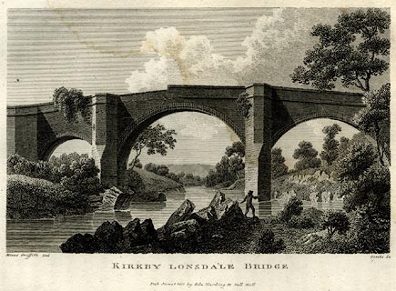 click to enlarge click to enlargePEN612.jpg Tipped in opposite p.117 of A Tour from Downing to Alston Moor, 1773, by Thomas Pennant. printed at :- "KIRKBY LONSDALE BRIDGE / Pub June 1 1801 by Edw Harding 98 Pall Mall." item:- Armitt Library : A1057.12 Image © see bottom of page |
|
|
|
||
| evidence:- | old print:- |
|
| source data:- | Print, uncoloured engraving, View of the Bridge over the Lone, ie Devil's Bridge,
Kirkby Lonsdale, Westmorland, published by the Gentleman's Magazine, 1753. click to enlarge click to enlargeGM22.jpg Tipped in opposite p.357 in the Gentleman's Magazine vol.23, 1753. There is accompanying text p.355. printed at :- "A View of the Bridge over the LONE, near / Kirkby Lonsdale in Westmorland." item:- Armitt Library : A5735 : 9 Image © see bottom of page |
|
|
|
||
| sundial |
||
|
|
||
| hearsay:- |
Believed to have been built by the monks of St Mary's Abbey, York, about 1365. The
three spans are 55, 55 and 28 feet, and have four ribs. The parapets are 45 feet above
mean river level; the roadway is 11.5 feet wide. |
|
|
|
||
Lakes Guides menu.