 Jefferys 1770 NY40SW

|

|
|
|
gazetteer links places may or may not be labelled on the map |
||

|
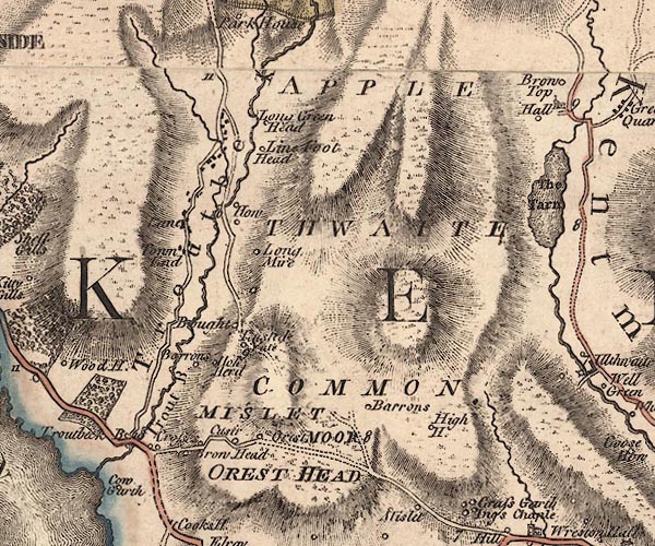
-- Applethwaite Common -- "APPLE THWAITE COMMON" |
|
|
|
-- Bought (?) -- "Bought" |
|
|
|
-- Browhead -- "Brow Head" |
|
|
|
-- Calgarth Hall -- "Cow Garth" |
|
|
|
-- Causeway Farm, The -- "Cusir" |
|
|
|
-- Common, The -- "MISLET MOOR" |
|
|
|
-- Crosses, The -- "Crosses" |
|
|
|
-- Fusethwaite Yeat -- "T[u]sted Yate" |
|
|
|
-- High Borrans -- "Barrons" |
|
|
|
-- High House -- "High H." |
|
|
|
-- Holehird -- "Hole Herd" |
|
|
|
-- Howe, The -- "How" |
|
|
|
-- Kentmere Hall -- "Hall" |
|
|
|
-- Lane -- "Lane" |
|
|
|
-- Limefitt House -- "Line Foot Head" |
|
|
|
-- Long Green Head -- "Long Green Head" |
|
|
|
-- Longmire -- "Long Mire" |
|
|
|
-- Low Borrans -- "Borrons" |
|
|
|
-- Near Orrest -- "Orest" |
|
|
|
-- Orrest Head -- "OREST HEAD" |
|
|
|
-- Ings to Troutbeck |
|
|
|
-- Windermere to Kirkstone Pass |
|
|
|
-- Town End -- "Town End" |
|
|
|
-- Trout Beck -- "Trout B." |
|
|
|
-- Troutbeck Bridge -- "Troutbeck B." |
|
|
|
-- Troutbeck -- "Troutbeck" |
|
|
civil parishes The area roughly includes parts of parishes:- Lakes Windermere Kentmere Hugill |
||
|
|
||
|
|
Lakes Guides menu. | |