 Old Cumbria Gazetteer
 |
 |
|
|
| included in:- |
 road, Windermere to Penrith road, Windermere to Penrith |
||
| road, Windermere to Kirkstone Pass | |||
| Windermere to Kirkstone Pass | |||
| Kirkstone Pass to Windermere | |||
| A592 | |||
| civil parish:- | Lakes (formerly Westmorland) | ||
| county:- | Cumbria | ||
| locality type:- | road route | ||
| coordinates:- | SD406993 | ||
| coordinates:- | NY401080 | ||
| 1Km square:- | SD4099 | ||
| 10Km square:- | SD49 | ||
| 10Km square:- | NY40 | ||
|
|
|||
| evidence:- | old map:- Jefferys 1770 (Wmd) |
||
| source data:- | Map, 4 sheets, The County of Westmoreland, scale 1 inch to 1
mile, surveyed 1768, and engraved and published by Thomas
Jefferys, London, 1770.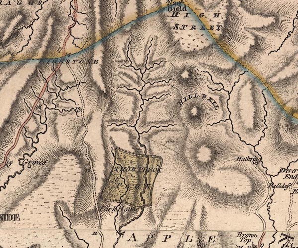 J5NY40NW.jpg 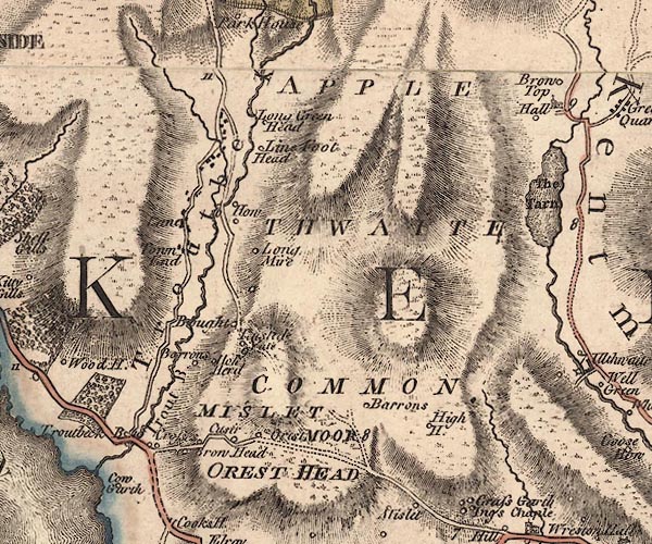 J5NY40SW.jpg double line; road, with mile numbers item:- National Library of Scotland : EME.s.47 Images © National Library of Scotland |
||
|
|
|||
| evidence:- | old text:- Martineau 1855 |
||
| source data:- | Guide book, A Complete Guide to the English Lakes, by Harriet
Martineau, published by John Garnett, Windermere, Westmorland,
and by Whittaker and Co, London, 1855; published 1855-76. goto source Page 33:- "... he [the tourist] will take a car for the day, and go by Troutbeck to Patterdale." "The country people will tell him, as he turns up to Troutbeck at Cook's House, that he is going to see "the handsomest view in these parts,- especially at the back-end of the year." And wonderfully fine the views are, as the road ascends, commanding the entire lake, and the whole range of mountains from Coniston Old Man to Fairfield. ..." "..." goto sourcePage 35:- "... The dale [Troutbeck] looks from the uplands as if it had been scooped out between the ridges with a gigantic scoop. Its levels are parcelled out into small fields, of all manner of shapes; and the stream,- the beck abounding in trout,- winds along the bottom, from the foot of High Street, to fall into the lake just by Calgarth." "The road now followed by the tourist descends into the vale sharply, by the abode of John Wilson, Esq., at The How, and crosses the bridge, in full view of the chapel, ... Immediately beyond the bridge, the road mounts again very steeply, till it joins that which runs along the hill sides, on the western side of the valley. This road is to be followed up the valley; and the tourist must lose none of its beauties. Behind him, there are views of the receding lake, now diminished to the likeness of a cabinet picture:- below, is the deep vale with its green levels: opposite, the grassy slopes ascend to the ridges of High Street and Hill Bell; and before him, Troutbeck Tongue" goto sourcePage 36:- "protrudes, splitting the valley into two, and being itself most lovely with its farmstead, and dropped thorns, and coppice and grey rocks: while, behind and above it, the vale head rises into grandeur, with its torrents leaping down, and its pathway winding up, indicating the pass into Mardale. The stranger is not going that way, however. He turns over a gentler pass to the left, which leads him, on the slope of Wansfell, away from Troutbeck. As he bids farewell to the Tongue, he sees the summit of Kirkstone before him. He is passing over the somewhat boggy upland where the Stock takes its rise, to flow down to and through Ambleside, after having taken the leap called Stockghyll Force. The tourist may see that in the evening, if there is time:- he is going the other way now." "His road meets the one from Ambleside at a small public-house, ... In clear weather, the sea is seen hence, and the thread of smoke from its steamers. The head of Windermere lies like a pond below: the little Blelham tarn, near Wray Castle, glitters behind; and range beyond range of hills recedes to the horizon. Near at hand, all is very wild. The Ambleside road winds up steeply between grey rocks and moorland pasture, and dashing streams; and the Kirkstone mountain has probably mists driving about its head. There is something wilder to come, however,- the noted Kirkstone Pass,- the great pass of the district. The descent begins about a quarter of a mile beyond the house. ..." |
||
|
|
|||
| evidence:- | old map:- Prior 1874 map 1 |
||
| source data:- | Map, uncoloured engraving or lithograph? Winander Mere, scale
about 2.5 miles to 1 inch, published by John Garnett,
Windermere, Westmorland, 1874. click to enlarge click to enlargePI03M1.jpg "To Troutbeck" double line; road item:- private collection : 133.1 Image © see bottom of page |
||
|
|
|||
| evidence:- | gradient diagram:- Gall and Inglis 1890s-1900s (Roads) |
||
| source data:- | Contour Road Book of England, Northern Division, by Harry R G Inglis, published by
Gall and Inglis, 25 Paternoster Square, London and Edinburgh, 1898.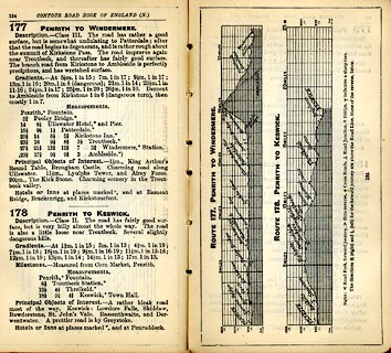 click to enlarge click to enlargeIG5177.jpg Itinerary, with gradient diagram, route 177, Penrith to Windermere, and route 178, Penrith to Keswick, Westmorland and Cumberland, 1898. item:- JandMN : 763.14 Image © see bottom of page |
||
|
|
|||
| evidence:- | old strip map:- CTC 1911 (Roads) |
||
| source data:- | Page 93 of Cyclists' Touring Club British Road Book new series vol.6, edited by F
B Sandford, published by Thomas Nelson and Sons, London etc, 1911.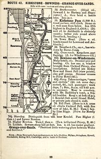 click to enlarge click to enlargeCTC293.jpg Strip road map, route 42, Kirkstone Bowness Grange-over-Sands, part of Haydon Bridge to Grange-over-Sands, scale roughly 5 miles to 1 inch. Together with an itinerary and gradient diagram. item:- JandMN : 491.93 Image © see bottom of page |
||
|
|
|||
| places:- | Windermere Cook's Corner, Windermere Kirkstone Pass, Patterdale |
||
|
|
|||
Lakes Guides menu.