 Garnett 1850s-60s NY10


|

|
|
|
gazetteer links places may or may not be labelled on the map |
||

|
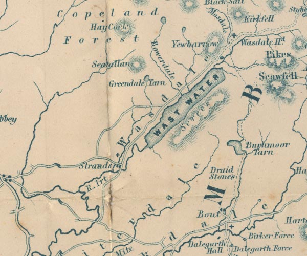
-- Bleng, River |
|
|
|
-- Boot -- "Bout" |
|
|
|
-- Bowderdale -- "Bowerdale" |
|
|
|
-- Burnmoor Stone Circles -- "Druid Stones" |
|
|
|
-- Burnmoor Tarn -- "Burnmoor Tarn" |
|
|
|
-- Greendale Tarn -- "Greendale Tarn" |
|
|
|
-- Haycock -- "Hay Cock" |
|
|
|
-- Irt, River -- "R. Irt" |
|
|
|
-- Low Tarn |
|
|
|
-- Nether Wasdale -- "Strands" |
|
|
|
-- Screes, The -- "Screes" |
|
|
|
-- Seatallan -- "Seatallan" |
|
|
|
-- St Catherine's Church |
|
|
|
-- St Michael and All Angels Church |
|
|
|
-- St Olaf's Church |
|
|
|
-- Wasdale Head -- "Wasdale Hd." |
|
|
|
-- Wasdale -- "Wasdale" |
|
|
|
-- Wast Water -- "WAST WATER" |
|
|
|
-- Whillan Beck |
|
|
|
-- Yewbarrow -- "Yewbarrow" |
|
|
civil parishes The area roughly includes parts of parishes:- Gosforth Eskdale Ennerdale and Kinniside Nether Wasdale Irton with Santon Muncaster |
||
|
|
||
|
|
Lakes Guides menu. | |