 Old Cumbria Gazetteer
 |
 |
|
| Screes, Wasdale | ||
| locality:- | Illgill Head | |
| locality:- | Wasdale | |
| civil parish:- | Eskdale (formerly Cumberland) | |
| county:- | Cumbria | |
| locality type:- | scree | |
| coordinates:- | NY15520453 (etc) | |
| 1Km square:- | NY1504 | |
| 10Km square:- | NY10 | |
|
|
||
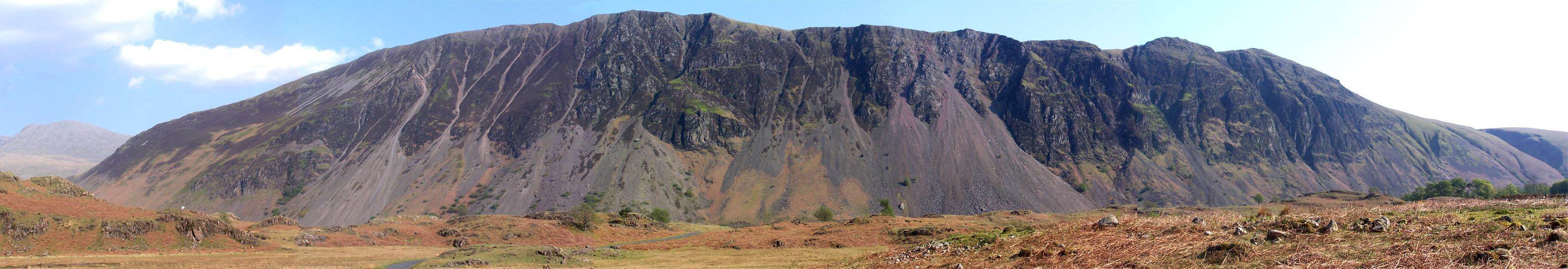
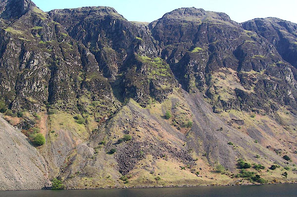 BMC18.jpg (taken 11.5.2006) 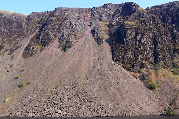 BMC19.jpg (taken 11.5.2006) |
||
|
|
||
| evidence:- | old map:- OS County Series (Cmd 79 6) placename:- Screes |
|
| source data:- | Maps, County Series maps of Great Britain, scales 6 and 25
inches to 1 mile, published by the Ordnance Survey, Southampton,
Hampshire, from about 1863 to 1948. |
|
|
|
||
| evidence:- | old map:- Donald 1774 (Cmd) placename:- Screes |
|
| source data:- | Map, hand coloured engraving, 3x2 sheets, The County of Cumberland, scale about 1
inch to 1 mile, by Thomas Donald, engraved and published by Joseph Hodskinson, 29
Arundel Street, Strand, London, 1774.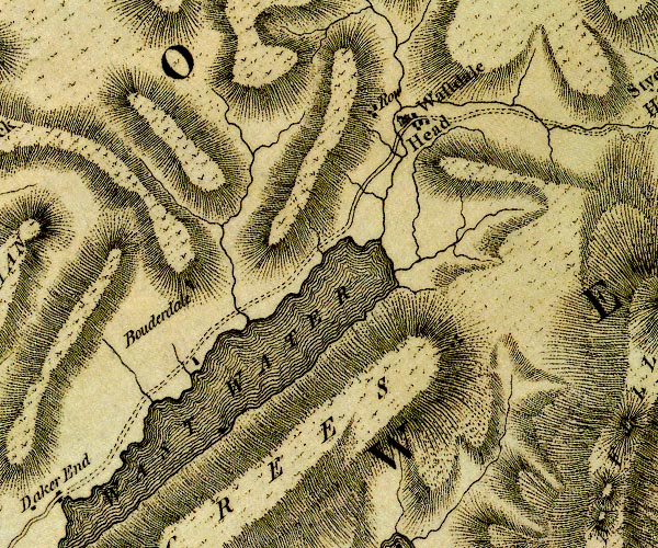 D4NY10NE.jpg 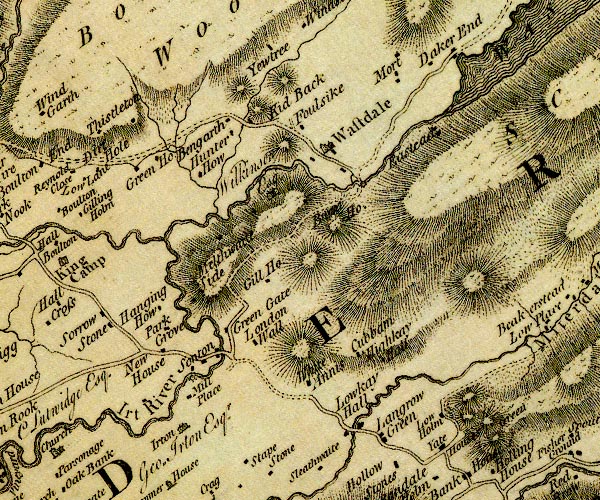 D4NY10SW.jpg 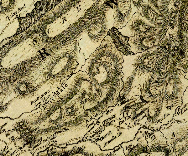 D4NY10SE.jpg "SCREES" hill hachuring; a hill or mountain item:- Carlisle Library : Map 2 Images © Carlisle Library |
|
|
|
||
| evidence:- | old text:- Green 1810 placename:- Skrees, The item:- rain; storm; hail |
|
| source data:- | Set of prints, soft ground etchings, Sixty Studies from Nature,
by William Green, Ambleside, Westmorland, drawn 1808-10,
published 1810. goto source goto sourcepage 92:- "..." "The Skrees stretch from the head to the foot of the lake on its eastern side, and, from the feet of the monstrous crags which often overhang their bases, the mountain is one continued surface of loose stones, which occasionally shiver into the water; nay, the rocks themselves have been known to fall, to the terror and dismay of their peaceful neighbours, and so much in volume, as to shake the very foundations of the" page 93:- "mountains. - They are now at rest, except in frosty weather, when, sometimes a large stone is detached from the rest, and hurled to the lake." "In the writer's memorandum-book is the following passage: "1803, July 20, Went from Mr. Fletcher's, at Wastdale Head, to the foot of the lake, crossed the outlet, and got about half a mile up the side of the lake under the Screes; the morning was uncommonly hot, and suddenly, and unexpectedly, came on the most tremendous storm of thunder, lightning, and hail, I was ever witness to; though for a long time sheltered under a thick holly bush, I was free from the hail, yet when the rain began to pour down, the bush was more injurious to me than servicable; and before I could get to the foot of the water, my clothes were as completely saturated with wet, as if I had been dragged for an hour in the lake: I got to Mr. Lancelot Porter's," goto sourcepage 94:- "whose wife is sister to Mrs. Fletcher, there I was kindly treated. It was in this house my friend W--- and I were hospitably fed when first, in the year 1800, we visited Wast Water. - My friend H--- did not go from home that day, but made some admirable studies of dogs and sheep."" "The writer, when under the bush. was not without his apprehensions, for though for years no great quantity of crag had fallen from the Screes, yet the dread of such a circumstance, on some degree, annoyed him. Notwithstanding the torrents of rain, he had the curiosity to examine the hailstones, many of which were as large as a moderately sized walnut, and the contents, a globe of congealed snow inserted in a cone of transparent ice." "This storm was partial, its diameter being not more than half a mile; ..." "The artist's port folio, carried under his coat, till his coat was as wet inside as outside, was almost dissolved, and the drawing paper much injured; the afternoon was of a delightful temperature, and after refreshing, patching, and repairing, the business of an artist was resumed till the coming on of night." |
|
|
|
||
| evidence:- | old print:- Green 1815 item:- fishing |
|
| source data:- | Print, coloured aquatint, Screes on Wast Water, Nether Wasdale, Cumberland, by William
Green, Ambleside, Westmorland, 1815.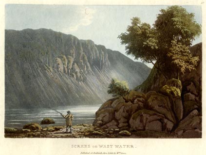 click to enlarge click to enlargeGN0553.jpg Plate 57 in Lake Scenery. printed at upper right:- "57" printed at bottom:- "SCREES on WAST WATER. / Published at Ambleside, June 1, 1815, by Wm. Green." item:- Armitt Library : A6646.53 Image © see bottom of page |
|
|
|
||
| evidence:- | old text:- Farington 1816 placename:- Screes |
|
| source data:- | Descriptive text:- "... The Screes, a very lofty ridge of mountains, runs along the southern shore, and
the loose rocks on its sides are in almost constant motion, shivering down into the
water: sometimes, however, their progress is arrested by large fragments of rocks,
which have unaccountably stopt in their descent, and by parts, which being too precipitous
for the stones to rest on, are darkened with mosses; and every variety of form and
colour is reflected by the dark water at its foot." item:- Armitt Library : A6666.18 Image © see bottom of page |
|
|
|
||
| evidence:- | old map:- Otley 1818 placename:- Screes |
|
| source data:- | Map, uncoloured engraving, The District of the Lakes,
Cumberland, Westmorland, and Lancashire, scale about 4 miles to
1 inch, by Jonathan Otley, 1818, engraved by J and G Menzies,
Edinburgh, Scotland, published by Jonathan Otley, Keswick,
Cumberland, et al, 1833. OT02NY10.jpg item:- JandMN : 48.1 Image © see bottom of page |
|
|
|
||
| evidence:- | outline view:- Otley 1823 (8th edn 1849) placename:- Screes, The |
|
| source data:- | Engraving, outline view of mountains, Mountains of Wast Water as seen from Nether
Wasdale, drawn by T Binns, engraved by O Jewitt, opposite p.22 of A Descriptive Guide
of the English Lakes, by Jonathan Otley, 8th edition, 1849.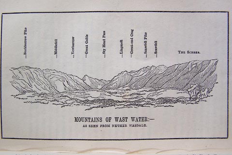 click to enlarge click to enlargeO80E13.jpg item:- Armitt Library : A1180.14 Image © see bottom of page |
|
|
|
||
| evidence:- | outline view:- Otley 1823 (5th edn 1834) |
|
| source data:- | Print, woodcut outline view, Mountains of Wast Water, by
Jonathan Otley, Keswick, Cumberland, 1830.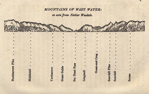 click to enlarge click to enlargeOT2E07.jpg Printed on p.31 of A Concise Description of the English Lakes, by Jonathan Otley, 5th edition, 1834. "THE MOUNTAINS OF WAST WATER: as seen from Nether Wasdale." "Buckbarrow Pike / Middlefell / Yewbarrow / Great Gable / Sty Head Pass / Lingmell / Great-end Crag / Scawfell Pike / Scawfell / Screes" item:- JandMN : 48.8 Image © see bottom of page |
|
|
|
||
| evidence:- | descriptive text:- Otley 1823 (5th edn 1834) |
|
| source data:- | Guide book, A Concise Description of the English Lakes, the
mountains in their vicinity, and the roads by which they may be
visited, with remarks on the mineralogy and geology of the
district, by Jonathan Otley, published by the author, Keswick,
Cumberland now Cumbria, by J Richardson, London, and by Arthur
Foster, Kirkby Lonsdale, Cumbria, 1823; published 1823-49,
latterly as the Descriptive Guide to the English Lakes. goto source Page 29:- "..." "The mountains environing Wast Water are lofty and majestic. A shivery mountain side called the Screes bounds the lake on the south-east, extending quite into the water; so that it cannot be passed on that side, even by a pedestrian, without considerable difficulty, and some danger. ..." |
|
|
|
||
| evidence:- | outline view:- Otley 1823 (8th edn 1849) placename:- Screes, The |
|
| source data:- | Engraving, outline view of mountains, Mountains of Wast Water as seen from Nether
Wasdale, drawn by T Binns, engraved by O Jewitt, opposite p.22 of A Descriptive Guide
of the English Lakes, by Jonathan Otley, 8th edition, 1849. click to enlarge O80E13.jpg item:- Armitt Library : A1180.14 Image © see bottom of page |
|
|
|
||
| evidence:- | descriptive text:- Ford 1839 (3rd edn 1843) placename:- Screes |
|
| source data:- | Guide book, A Description of Scenery in the Lake District, by
Rev William Ford, published by Charles Thurnam, Carlisle, by W
Edwards, 12 Ave Maria Lane, Charles Tilt, Fleet Street, William
Smith, 113 Fleet Street, London, by Currie and Bowman,
Newcastle, by Bancks and Co, Manchester, by Oliver and Boyd,
Edinburgh, and by Sinclair, Dumfries, 1839. goto source Page 73:- "... on the opposite side are the Screes, which seem going to decay, their foundation in the water, and their surface and soil being gone, while immense debris and torrents of rocks and stones cover their sides. This range of fell prevents a circumambulation of the lake. ..." |
|
|
|
||
| evidence:- | old map:- Ford 1839 map placename:- Screes |
|
| source data:- | Map, uncoloured engraving, Map of the Lake District of
Cumberland, Westmoreland and Lancashire, scale about 3.5 miles
to 1 inch, published by Charles Thurnam, Carlisle, and by R
Groombridge, 5 Paternoster Row, London, 3rd edn 1843.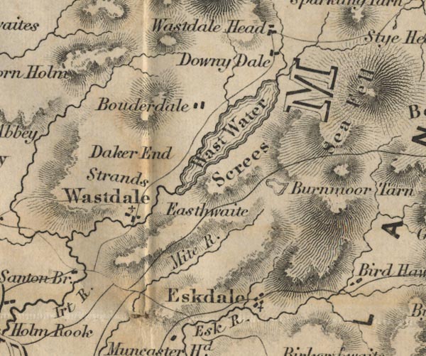 FD02NY10.jpg "Screes" Hill hachuring. item:- JandMN : 100.1 Image © see bottom of page |
|
|
|
||
| evidence:- | old map:- Garnett 1850s-60s H placename:- Screes |
|
| source data:- | Map of the English Lakes, in Cumberland, Westmorland and
Lancashire, scale about 3.5 miles to 1 inch, published by John
Garnett, Windermere, Westmorland, 1850s-60s.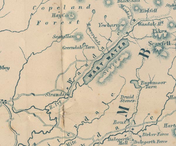 GAR2NY10.jpg "Screes" hill hachuring item:- JandMN : 82.1 Image © see bottom of page |
|
|
|
||
| evidence:- | old text:- Martineau 1855 |
|
| source data:- | Guide book, A Complete Guide to the English Lakes, by Harriet
Martineau, published by John Garnett, Windermere, Westmorland,
and by Whittaker and Co, London, 1855; published 1855-76. goto source Page 114:- "... the right, and close at hand, the Screes present their remarkable sweep of débris, and crests streaked with red, grey, and vivid green, and here and there cloven for the passage of cataracts from the brow, which tumble down through the gloom of woods. Hawlghyll is the largest of these ravines. ..." "..." goto sourcePage 119:- "The lake is three and a-half miles long, and has the Screes for its south-eastern shore. The line of this singular range is almost unbroken. The crags are hidden, about a-third of the way down, by the slope of many-coloured débris which slants right into the lake. The summer thunderstorm and the winter tempest sometimes shiver the loosely-compacted crags above; and then, when a mass comes thundering down, and splashes into the lake, the whole range feels the shock, and slides of stones rush into the water, and clouds of dust rise into the air." "..." goto sourcePage :- "... there is no road, of course, under the Screes, though the shepherds venture along a perilous thread of a path in the loose débris." |
|
|
|
||
| evidence:- | old photograph:- Bell 1880s-1940s |
|
| source data:- | Photograph, sepia, The Screes, Wasdale, Nether Wasdale, Cumberland, by Herbert Bell,
photographer, Ambleside, Westmorland, 1890s.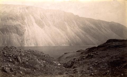 click to enlarge click to enlargeHB0784.jpg item:- Armitt Library : ALPS447 Image © see bottom of page |
|
|
|
||
| evidence:- | old photograph:- Bell 1880s-1940s |
|
| source data:- | Photograph, black and white, The Screes, Wasdale, Nether Wasdale, Cumberland, by Herbert
Bell, photographer, Ambleside, Westmorland, 1890s.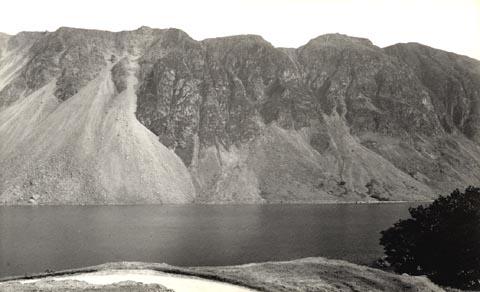 click to enlarge click to enlargeHB0785.jpg stamped at reverse:- "HERBERT BELL / Photographer / AMBLESIDE" item:- Armitt Library : ALPS448 Image © see bottom of page |
|
|
|
||
| evidence:- | old photograph:- Bell 1880s-1940s |
|
| source data:- | Photograph, black and white, The Screes, Wasdale, Nether Wasdale, Cumberland, by Herbert
Bell, photographer, Ambleside, Westmorland, 1890s.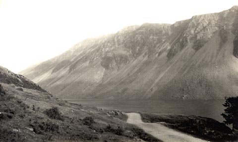 click to enlarge click to enlargeHB0786.jpg internegative at lower left:- "H. Bell" stamped at reverse:- "HERBERT BELL / Photographer / AMBLESIDE" item:- Armitt Library : ALPS449 Image © see bottom of page |
|
|
|
||
| evidence:- | old photograph:- Bell 1880s-1940s item:- scree |
|
| source data:- | Photograph, sepia, The Screes by Wast Water, Wasdale, Eskdale, Cumberland, by Herbert
Bell, photographer, Ambleside, Westmorland, 1890s.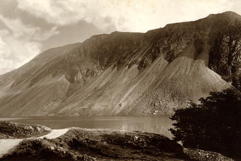 click to enlarge click to enlargeHB0882.jpg item:- Armitt Library : ALPS553 Image © see bottom of page |
|
|
|
||
| evidence:- | old print:- Heaton Cooper 1905 (edn 1908) placename:- Wastwater Screes |
|
| source data:- | Print, colour halftone, Wastwater Screes, Wasdale, Nether Wasdale, Cumberland, from
a watercolour painting by Alfred Heaton Cooper, published by Adam and Charles Black,
London, 2nd edn 1908.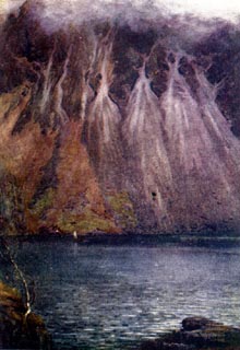 click to enlarge click to enlargeHC0133.jpg Opposite p.88 of The English Lakes, painted by Alfred Heaton Cooper, described by William T Palmer. printed at tissue opposite the print:- "WASTWATER SCREES" printed at signed lower right:- "[A HEATON COOPER]" item:- JandMN : 468.33 Image © see bottom of page |
|
|
|
||
| evidence:- | old photograph:- Marr 1916 placename:- Screes, The |
|
| source data:- | Photograph, halftone print, The Screes, Wastwater, Eskdale, Cumberland, 1916.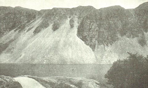 click to enlarge click to enlargeMA1227.jpg item:- JandMN : 173.35 Image © see bottom of page |
|
|
|
||
| evidence:- | outline view:- Seascale 1920s-30s placename:- Screes |
|
| source data:- | Print, uncoloured engraving, outline view, mountains from Seascale, published by Edward
Burrow and Son, Cheltenham, Gloucestershire, 1920s-30s.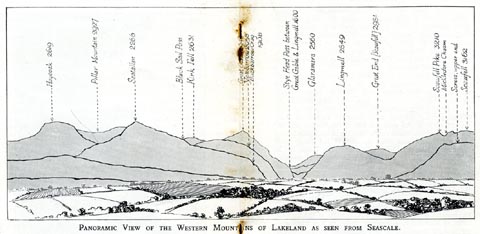 click to enlarge click to enlargeSES113.jpg "PANORAMIC VIEW OF THE WESTERN MOUNTAINS OF LAKELAND AS SEEN FROM SEASCALE." "... Screes, upper end ..." item:- JandMN : 1079.13 Image © see bottom of page |
|
|
|
||
| evidence:- | old print:- Pearson 1900s placename:- Wastwater Screes, The |
|
| source data:- | Print, halftone photograph, The Wastwater Screes, Wasdale, Eskdale, Cumberland, published
by C Arthur Pearson, Henrietta Street, London, 1900s.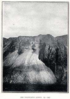 click to enlarge click to enlargePS1E71.jpg On p.200 of Pearson's Gossipy Guide to the English Lakes and Neighbouring Districts. printed at bottom:- "THE WASTWATER SCREES. (p.199)." item:- Armitt Library : A1188.78 Image © see bottom of page |
|
|
|
||
| evidence:- | outline view:- Jenkinson 1875 placename:- Screes, The |
|
| source data:- | Print, lithograph, outline view, Panoramic Sketches from Skiddaw, Cumberland, by Edwin
A Pettitt, London, published by Edward Stanford, 55 Charing Cross, London, 1875. click to enlarge click to enlargeJk01E2.jpg "... The Screes ..." item:- JandMN : 28.8 Image © see bottom of page |
|
|
|
||
| evidence:- | outline view, old print:- Matthew 1866 placename:- Screes, The |
|
| source data:- | Print, engraving, outline view, Mountains as seen from the Road to Wastwater near
Murthwaiteside, Cumberland, published by J Richardson, Highgate, Kendal, Westmorland,
1866.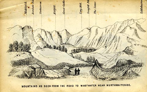 click to enlarge click to enlargeMW1E03.jpg Tipped in before p.1 of The English Lakes, Peaks and Passes, from Kendal to Keswick, by George King Matthew. printed at bottom:- "MOUNTAINS AS SEEN FROM THE ROAD TO WASTWATER NEAR MURTHWAITESIDE." printed at caption to mountains:- "... The Serees. ..." item:- Armitt Library : A1168.3 Image © see bottom of page |
|
|
|
||
| evidence:- | old print:- Prior 1865 placename:- Screes, The |
|
| source data:- | Print, uncoloured engraving, The Screes and Wast Water, Nether Wasdale, Cumberland,
published by John Garnett, Windermere, Westmorland, and by Simpkin, Marshall and Co,
London, 1865.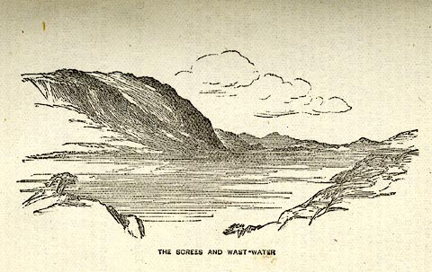 click to enlarge click to enlargePI0112.jpg Included on page 89 of the guide book, Ascents and Passes in the Lake District of England, by Herman Prior. printed at bottom:- "THE SCREES AND WAST-WATER" item:- JandMN : 235.14 Image © see bottom of page |
|
|
|
||
| evidence:- | outline view:- Black 1856 (23rd edn 1900) placename:- Screes |
|
| source data:- | Print, lithograph, Outline Views, Haws and Wastwater - Mountains as seen from Burn-Banks
near the Foot of Hawes Water, and Mountains as seen near Nether Wastdale at the First
Bridge on the road to Wast-Water, by J Flintoft, Keswick, Cumberland, engraved by
R Mason, Edinburgh, Lothian, about 1900.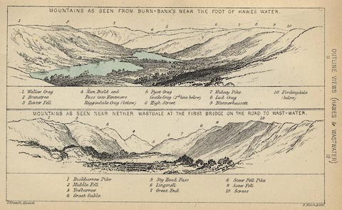 click to enlarge click to enlargeBC08E6.jpg "... 10 Screes ..." item:- JandMN : 37.21 Image © see bottom of page |
|
|
|
||
| evidence:- | outline view:- Martineau 1855 |
|
| source data:- | Print, engraving, Wastwater, drawn by L Aspland, engraved by W Banks, Edinburgh, published
by John Garnett, Windermere, Westmorland, and by Whittaker and Co, London, 1855.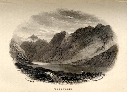 click to enlarge click to enlargeMNU116.jpg Opposite p.118 in A Complete Guide to the English Lakes, by Harriet Martineau. printed at bottom left, right, centre:- "L Aspland Delt. / W Banks Sc Edinr. / WASTWATER." item:- Armitt Library : A1159.16 Image © see bottom of page |
|
|
|
||
| evidence:- | outline view, old text:- Linton 1852 placename:- Screes |
|
| source data:- | Print, engraving, outline views, Mountains as Seen from the Esk Viaduct, the Eskmeals
Viaduct, and Mountains as Seen from the Viaduct near Drigg, the Irt Viaduct, Whitehaven
and Furness Junction Railway, Cumberland, engraved by W H Lizars, Edinburgh, published
by Whittaker and Co, London, and by R Gibson and Son and by Callander and Dixon, Whitehaven,
Cumberland, 1852.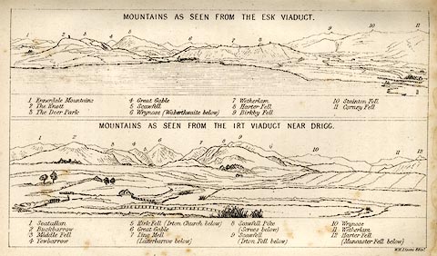 click to enlarge click to enlargeLN1E13.jpg Tipped in opposite p.86 of A Handbook of the Whitehaven and Furness Railway, by John Linton. item:- Armitt Library : A1158.11 Image © see bottom of page |
|
|
|
||
| evidence:- | old print:- Garnett 1850s-60s F |
|
| source data:- | Print, uncoloured engraving, Wastwater, Cumberland, drawn by L Aspland, engraved by
William Banks, Edinburgh, published by John Garnett, Windermere, Westmorland, 1850s-60s?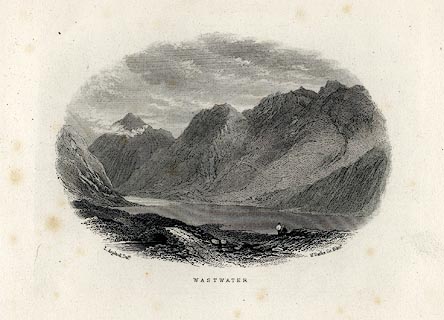 click to enlarge click to enlargeGAR710.jpg Included in Views of the English Lakes. printed at bottom:- "L. Aspland Delt. / WASTWATER. / W. Banks Sc. Edinr." item:- JandMN : 165.10 Image © see bottom of page |
|
|
|
||
| evidence:- | outline view:- Black 1841 (3rd edn 1846) placename:- Screes |
|
| source data:- | Print, engraving, outline view, Mountains as seen from Burn Banks near the Foot of
Hawes Water, and Mountains as seen near Strands in Wastdale at the First bridge on
the Road to Wast Water, by J Flintoft, Keswick, Cumberland, engraved by R Mason, Edinburgh,
Lothian, about 1846.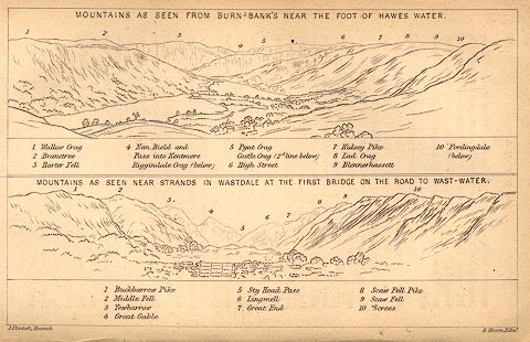 click to enlarge click to enlargeBC02E8.jpg "... 10 Screes ..." item:- JandMN : 32.12 Image © see bottom of page |
|
|
|
||
| evidence:- | outline view:- placename:- Screes, The |
|
| source data:- | Print, hand coloured engraving, Wast Water and Scawfell Pikes from the Road to Calder
Bridge, Cumberland, published by Sherwood and Co, London, 1836?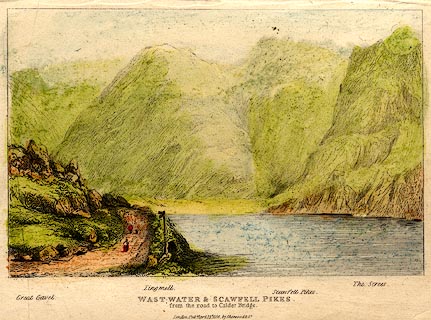 click to enlarge click to enlargePR0373.jpg Objects in the view are identified by a caption at the bottom - Great Gavel, Lingmell, Scawfell Pikes, The Screes. printed at bottom:- "WAST-WATER & SCAWFELL PIKES. / from the road to Calder Bridge. / London. Pubd. April 15th 1836 by Sherwood &Co." item:- Dove Cottage : 2008.107.373 Image © see bottom of page |
|
|
|
||
| evidence:- | old print with text:- Farington 1816 (plate 25) placename:- Screes |
|
| source data:- | Print, uncoloured engraving, Wastdale Village, drawn by Joseph Farington, engraved
by J Landseer, published by T Cadell and W Davies, Strand, London, 1815.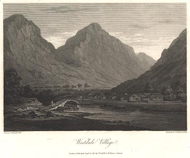 click to enlarge click to enlargeBNV37.jpg printed at bottom:- "... Wastdale Village. ..." Plate 25 in The Lakes of Lancashire, Westmorland and Cumberland ... with text by Thomas Hartwell Horne:- "... Screes, a very lofty ridge of mountains, runs along the southern shore, and the loose rocks on its sides are in almost constant motion, shivering down into the water: sometimes, however, their progress is arrested by large fragments of rocks, which have unaccountably stopt in their descent, and by parts, which being too precipitous for the stones to rest on, are darkened with mosses; and every variety of form and colour is reflected by the dark water at its foot." item:- private collection : 76 Image © see bottom of page |
|
|
|
||
 Click to enlarge BMC20.jpg (taken 11.5.2006) |
||
|
|
||
Lakes Guides menu.