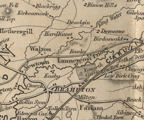
 Ford 1839 map NY56


|

|
|
|
gazetteer links places may or may not be labelled on the map |
||

|
-- Banks -- "Banks" |
|
|
|
-- Birchcraig -- "Low Birk Crag" |
|
|
|
-- Brampton -- "Brampton" |
|
|
|
-- Desoglin -- "Desolgin" |
|
|
|
-- Farlam -- "Farlam" |
|
|
|
-- Great Easby -- "Easby" |
|
|
|
-- Hadrian's Wall |
|
|
|
-- Hardhurst -- "Hardhurst" |
|
|
|
-- King Water -- "King Water" |
|
|
|
-- Kirkcambeck -- "Kirkcamock" |
|
|
|
-- Lanercost Priory -- "Lannercost Priory" |
|
|
|
-- Milton -- "Milton" |
|
|
|
-- Naworth Castle (?) -- "Naworth Castle" |
|
|
|
-- Newcastle and Carlisle Railway-- Newcastle and Carlisle
Railway-- Newcastle and Carlisle Railway-- Newcastle and Carlisle
Railway-- Newcastle and Carlisle Railway -- "NEWCASTLE AND
CARLISLE RAILWAY" |
|
|
|
-- Brampton to Carlisle -- "C to B 9 Ms." |
|
|
|
-- Haltwhistle to Brampton |
|
|
|
-- Triermain -- "Demesne" |
|
|
|
-- Walton -- "Walton" |
|
|
civil parishes The area roughly includes parts of parishes:- Stapleton Askerton Hethersgill Walton Irthington Waterhead Kingwater Brampton Burtholme Nether Denton Farlam |
||
|
|
||
|
|
Lakes Guides menu. | |