 Crosthwaite 1783-94, tetrad SD39D

|

|
|
|
gazetteer links places may or may not be labelled on the map |
||

|
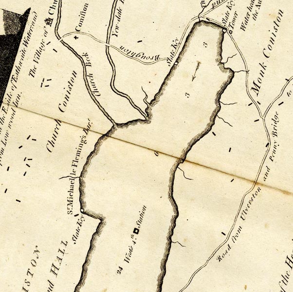
-- Church Beck -- "Church Beck" |
|
|
|
-- Church Bridge, Coniston |
|
|
|
-- Coniston -- "The Village of Church Coniston" --
"Church Coniston" |
|
|
|
-- Coniston Hall -- "CONISTON PARK and HALL / Sr. Michael le
Fleming's Bart." |
|
|
|
-- Kirby Quay -- "Slate Key" |
|
|
|
-- -- "Slate Key" |
|
|
|
-- Lands Point |
|
|
|
-- Monk Coniston -- "Monk Coniston" |
|
|
|
-- Ulverston to Coniston -- "Road from Ulverston and Penny
Bridge to Hawkshead and Ambleside" -- "From the South
end of Coniston Lake to Ulverston bearing South; 7 1/2 Miles:
..." |
|
|
|
-- St Andrew's Church -- "Coniston Church" |
|
|
|
-- Coniston Water -- "West's 4th Station" -- "...
his [West's] 4th. is upon the Lake, one Mile and one Furlong from
its Head." |
|
|
|
-- -- "Tower" |
|
|
|
-- Water Head Pier -- "Slate Key" |
|
|
|
-- Water Head |
|
|
|
-- Yewdale Beck -- "Yew-dale Beck" |
|
|
|
-- Yewdale Bridge |
|
|
civil parishes The area roughly includes parts of parishes:- Coniston |
||
|
|
||
|
|
Lakes Guides menu. | |