 Old Cumbria Gazetteer
 |
 |
|
| included in:- |
 Coniston Water Coniston Water |
|
| viewpoint, Coniston Water by boat | ||
| site name:- | Coniston Water | |
| civil parish:- | Coniston (formerly Lancashire) | |
| county:- | Cumbria | |
| locality type:- | viewpoint | |
| 1Km square:- | SD3096 (etc) | |
| 10Km square:- | SD39 | |
|
|
||
| evidence:- | descriptive text:- West 1778 (11th edn 1821) |
|
| source data:- | Guide book, A Guide to the Lakes, by Thomas West, published by
William Pennington, Kendal, Cumbria once Westmorland, and in
London, 1778 to 1821. goto source Page 52:- "The next grand view is had in the boat, and from the centre of the lake, opposite to Coniston-hall. Looking towards the mountains, the lake spreads itself into a noble expanse of transparent water, and burst into a bay on each side, bordered with verdant meadows, and inclosed with a variety of grounds, rising in an exceedingly bold manner. The objects are beautifully diversified amongst themselves, and contrasted by the finest exhibition of rural elegance (cultivation, and pasturage, waving woods, and sloping inclosures, adorned by nature, and improved by art) under the bold sides of stupendous mountains, whose airy summits the elevated eye cannot now reach, and which almost deny access to human kind." "Following the line of shore from Coniston-hall, to the upper end of the lake, the village of Coniston is in full view, and consists of seats, groups of houses, farms, and cots, scattered in a picturesque manner over the cultivated slope. Some are snow-white, others gray; some stand forth on bold eminences at the head of green inclosures; backed with steep woods; others are pitched on sweet declivities, and seem hanging in the" goto sourcePage 53:- "air; some again are on a level with the lake; and all are neatly covered with blue slate, the produce of the mountains, and beautified with ornamental yews, hollies, and tall pines, or firs. This is a charming scene, when the morning sun tinges the whole with a variety of tints. In the point of beauty and centre of perspective, a white house, under a hanging wood, gives life to this picture. Here a range of dark rugged rocks rise abruptly, and deeply contrast the transparent surface of the lake, and the stripe of verdure that skirts their feet. The eastern shore is not less bold and embayed [1]." "[1] The slate brought down from the mountains is laid up here, till put on board boats that transport it to Water-foot." |
|
|
|
||
| evidence:- | old map:- Crosthwaite 1783-94 (Con) |
|
| source data:- | Map, uncoloured engraving, An Accurate Map of Coniston Lake,
scale about 3 inches to 1 mile, by Peter Crosthwaite, Keswick,
Cumberland, 1788, version published 1809.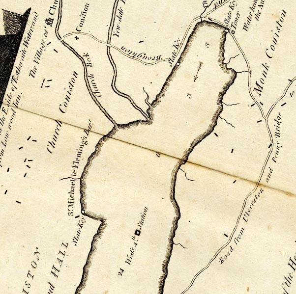 CTESD39D.jpg "West's 4th Station" square symbol on the lake "... his [West's] 4th. is upon the Lake, one Mile and one Furlong from its Head." item:- JandMN : 182.5 Image © see bottom of page |
|
|
|
||
| evidence:- | old map:- Crosthwaite 1783-94 (Con) placename:- station, Coniston, West 4 |
|
| source data:- | Series of maps, An Accurate Map of the Matchless Lake of
Derwent, of the Grand Lake of Windermere, of the Beautiful Lake
of Ullswater, of Broadwater or Bassenthwaite Lake, of Coniston
Lake, of Buttermere, Crummock and Loweswater Lakes, and
Pocklington's Island, by Peter Crosthwaite, Kendal, Cumberland
now Cumbria, 1783 to 1794. "West's 4th. Station" "... his 4th. is upon the Lake, one Mile and one Furlong from its Head." |
|
|
|
||
| indexing | ||
| person:- | author : West, Thomas |
|
| place:- | Coniston Water | |
| date:- | 1778 |
|
| period:- | 18th century, late | |
| period:- | 1780s | |
| item:- | guide book; Guide to the Lakes |
|
|
|
||
Lakes Guides menu.