 Robins 1818

|

|
|
|
map type:- Robins 1818 |
|
|
|
Maps, Westmoreland, scale about 5.5 miles to 1 inch, and
Cumberland? engraved by Neele, Strand, published by J and J
Cundee, Albion Press, London, 1815; published 1815-19.
and a general map, England and Wales. Published in 'Robins's Atlas of England and Wales, Accurately Engraved by Neele, from the Latest Surveys. London. Published by J. Robins and Co., Albion Press, Ivy Lane, Paternoster Row, 1819.' Published in 'The New British Traveller, or, Modern Panorama of England and Wales ... by James Dugdale LL.D. Illustrated by a complete set of maps, views of public buildings, antiquities, &c. &c. London: Printed and published by J. Robins and Co., Albion Press, Ivy-Lane, Paternoster Row. 1819.' |
||
|
(example map Armitt Library : ALMC2008.14.63)
|
||
| map feature:- | title cartouche & compass rose & up is N & scale line & lat and long scales & coast shaded & rivers & lakes & relief & hill hachuring & forests & parks & county & settlements & roads & canals | |
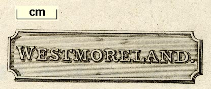
| inscription:- |
printed title cartouche, lower right
WESTMORELAND. |
|
| wxh, sheet:- | 26x20.5cm | |
| wxh, map:- | 240x188mm | |
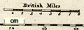
| inscription:- |
printed above scale line
British Miles |
|
| scale line:- | 8 miles = 38.3 mm | |
| scale:- | 1 to 340000 ? (1 to 336155 from scale line wrongly assuming a statute mile) | |
|
||
| references:- |
: 1819: Robins's Atlas of England and Wales: Robins, J and
Co (London) Dugdale, James: 1819: New British Traveller & Modern Panorama of England and Wales: Robins, J and Co (London) |
|
| sources:- |
Chubb 1927(CCCLXII) Armitt Library private collection Kendal Library Maps |
|
| items seen (illustrated items in bold):- | ||

|
Armitt Library : A1378.1 -- map -- Westmoreland | |
|
|
Armitt Library : ALMC2008.14.63 -- map -- Westmoreland | |
|
|
Carlisle Library : Map 183 -- map -- Westmoreland | |
|
|
Carlisle Library : Map 207 -- map -- Cumberland | |
|
|
Kendal Library : Map 15 -- map -- Westmoreland | |
|
|
Kendal Library : Map 56 -- map -- Westmoreland | |
|
|
private collection (92) -- map -- England and Wales | |