 Robins 1818

|

|
|
|
item:- Armitt Library : ALMC2008.14.63 image:- © see bottom of page |
click to enlarge |
|
|
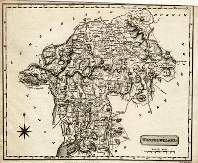
Map, uncoloured engraving, Westmoreland ie Westmorland,
scale about 5.5 miles to 1 inch, engraved by Neele, Strand,
published by J Robins and Co, Albion Press, London, 1818.
Included in Robin's Atlas of England and Wales. |
||

|
Robins 1818 | |
| map feature:- | plain cartouche & compass rose & up is N & scale line & lat and long scales (rectangular projection; Long. West from London) & coast shaded & rivers & lakes & relief & hill hachuring & forests & parks & county & settlements & distances from London & roads & canals | |
| inscription:- |
printed title cartouche, lower right
WESTMORELAND. |
|
| inscription:- |
printed bottom right, centre
Neele Sc. Strand / [ ] |
|
| longitude, Kendal:- | 2d 44.8m W | |
| inscription:- |
printed above scale line
British Miles |
|
| scale line:- | 8 miles = 38.3 mm | |
| wxh, sheet:- | 26x20.5cm | |
| wxh, map:- | 240x188mm | |
| scale:- | 1 to 340000 ? (1 to 336155 from scale line assuming a statute mile) | |