 Robins 1818

|

|
|
|
item:- Armitt Library : A1378.1 image:- © see bottom of page |
click to enlarge |
|
|
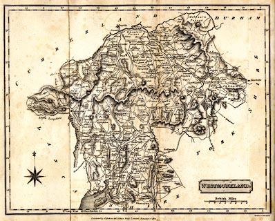
Map, uncoloured engraving, Westmoreland ie Westmorland,
scale about 5.5 miles to 1 inch, engraved by Neele, Strand,
published by J Robins and Co, Albion Press, London, 1818.
Folded and tipped in before the half title page of A Topographical and Historical Description of the County of Westmoreland, by John Hodgson, published by Sherwood, Neely and Jones, Paternoster Row, and by George Cowie and Co, 31 Poultry, London, 1820. |
||

|
Robins 1818 | |
| map feature:- | folded (3x1) & plain cartouche & compass rose & up is N & scale line & lat and long scales (rectangular projection; Long. West from London) & coast shaded & rivers & lakes & relief & hill hachuring & forests & parks & county & settlements & distances from London & roads & canals | |
| inscription:- |
printed title cartouche, lower right
WESTMORELAND. |
|
| inscription:- |
printed bottom right, centre
Neele Sc. Strand / Published by J. Robins & Co. Albion Press, London January 1st. 1818. |
|
| inscription:- |
printed above scale line
British Miles |
|
| scale line:- | 8 miles = 39.6 mm | |
| wxh, sheet:- | 27.5x22cm | |
| wxh, map:- | 247x197mm | |
| scale:- | 1 to 330000 ? (1 to 325120 from scale line assuming a statute mile) | |