 Moule 1836

|

|
|
|
map type:- Moule 1836 |
|
|
|
Maps, Westmoreland, scale about 5 miles to 1 inch, and
Cumberland, scale about 7.5 miles to 1 inch, by Thomas
Moule, published by George Virtue, Ivy Lane, Paternoster
Row, London, 1836; published 1836-37.
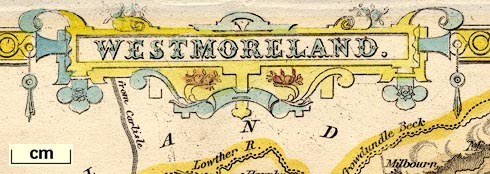
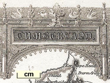
The Westmorland map has vignette views of Brougham Hall and the Keep of Appleby Castle; Cumberland has a vignette view of Carlisle; both maps have coats of arms. Published in 'The English Counties Delineated; or, A Topographical Description of England. Illustrated by a map of London, and a complete set of county maps. By Thomas Moule ... London: George Virtue, 26, Ivy Lane, Paternoster Row. 1836.' Also titled 'ENGLANDS TOPOGRAPHER or THE ENGLISH COUNTIES DELINEATED By THOMAS MOULE, ...' in 1836. The atlas size is 8 1/4 x 10 7/8 ins. Published in other editions, 1837 and 1838. |
||
|
(map example JandMN (5))
|
||
| map feature:- | interlace border & title cartouche & coat of arms & vignettes & scale line & coast form lines & rivers & relief & hill hachuring & parks & county & wards (hundreds) & table of wards & settlements & roads & canals & railways | |
| inscription:- |
printed title cartouche, top centre
WESTMORELAND. |
|
| inscription:- |
printed
ARMS OF APPLEBY / BURGII APPILEI SIGILLUM COMMUNITATIS coat of arms |
|
| inscription:- |
printed
ARMS OF KENDAL coat of arms |
|
| inscription:- |
printed
LORD LONSDALE coat of arms |
|
| inscription:- |
printed
FIEL PERO GESDICHADO coat of arms |
|
| scale line:- | 6 miles = 30.3 mm | |
| scale:- | 1 to 320000 ? (1 to 318682 from scale line) | |
| wxh, map:- | 267x202mm | |
|
||
| references:- |
Moule, Thomas: 1836 & 1837 & 1838: English Counties
Delineated & Topographical Description of England & Moule's
English Counties: Virtue, George (London) |
|
| sources:- |
Chubb 1927 (CCCCLXXI) JandMN Collection Armitt Library Wordsworth Trust Collection Carlisle Library Maps Kendal Library Maps |
|
| items seen (illustrated items in bold):- | ||

|
Armitt Library : ALMC2008.14.67.1 -- map -- Westmoreland | |
|
|
Armitt Library : ALMC2008.14.68 -- map -- Westmoreland | |
|
|
Carlisle Library : Map 17 -- map -- Cumberland | |
|
|
Carlisle Library : Map 191 -- map -- Westmoreland | |
|
|
Carlisle Library : Map 192 -- map -- Westmoreland | |
|
|
Carlisle Library : Map 332 -- map -- Cumberland | |
|
|
Dove Cottage : 2007.38.116 -- map -- Westmoreland | |
|
|
Dove Cottage : 2007.38.117 -- map -- Westmoreland | |
|
|
Dove Cottage : 2007.38.118 -- map -- Cumberland | |
|
|
Dove Cottage : 2007.38.129 -- descriptive text -- Westmorland, Northern Circuit | |
|
|
JandMN (5) -- map -- Westmoreland | |
|
|
JandMN (112) -- map -- Cumberland | |
|
|
JandMN (467) -- map -- Lancashire | |
|
|
Kendal Library : Map 20 -- map -- Westmoreland | |
|
|
Kendal Library : Map 61 -- map -- Westmoreland | |
|
|
Kendal Library : Map 106 -- map -- Westmoreland | |
|
|
Kendal Library : Map 107 -- map -- Westmoreland | |