 Moule 1836

|

|
|
|
item:- Dove Cottage : 2007.38.117 image:- © see bottom of page |
click to enlarge |
|
|
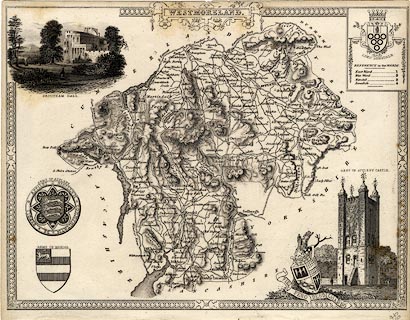
Map, uncoloured engraving, Westmoreland ie Westmorland,
scale about 5 miles to 1 inch, by Thomas Moule, published by
George Virtue, Ivy Lane, Paternoster Row, London, 1836.
Included in Moule's English Counties or The English Counties Delineated. There coats of arms of Appleby, Kendal - not the arms used now, the Earl of Lonsdale, and one unidentified; vignette scenes show Brougham Hall and the Keep of Appleby Castle. No railway is shown, and there is no scale line. |
||

|
Moule 1836 | |
| map feature:- | picture frame border & strapwork cartouche & coat of arms & vignettes & coast form lines & rivers & relief & hill hachuring & parks & county & wards (hundreds) & table of wards (hundreds) & settlements & roads & canals | |
| inscription:- |
printed title cartouche, top centre
WESTMORELAND. |
|
| scale:- | 1 to 320000 ? | |
| wxh, map:- | 278201mm | |