 Moule 1836

|

|
|
|
item:- JandMN (112) image:- © see bottom of page |
click to enlarge |
|
|
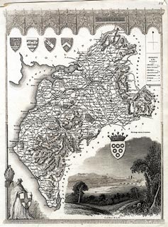
Map, uncoloured engraving, Cumberland, scale about 7.5
miles to 1 inch, by Thomas Moule, published by George
Virtue, Ivy Lane, Paternoster Row, London, 1836, edn about
1845?
Included in Moule's English Counties or The English Counties Delineated. There are coats of arms; a vignette scene shows Carlisle from the NW. The Newcastle and Carlisle Railway, and the Carlisle and Maryport Railway, are shown, both obviously engraved over an existing map. There is no scale line. |
||

|
Moule 1836 | |
| map feature:- | decorative border & plain cartouche & coat of arms & vignettes & north point & up is N & coast form lines & rivers & lakes & relief & hill hachuring & parks & county & wards (hundreds) & table of wards (hundreds) & settlements & roads & canals & railways | |
| inscription:- |
printed title cartouche, upper right of centre
CUMBERLAND. |
|
| wxh, map:- | 194x262mm | |
| scale:- | 1 to 470000 ? (estimate) | |