 Moule 1836

|

|
|
|
item:- Armitt Library : ALMC2008.14.68 image:- © see bottom of page |
click to enlarge |
|
|
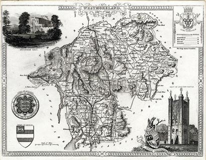
Map, uncoloured engraving, Westmoreland ie Westmorland,
scale about 5 miles to 1 inch, by Thomas Moule, published by
George Virtue, Ivy Lane, Paternoster Row, London, 1836.
Included in Moule's English Counties or The English Counties Delineated. There are coats of arms of Appleby, Kendal - not the arms used now, the Earl of Lonsdale, and an unidentified arms; vignette scenes show Brougham Hall and the Keep of Appleby Castle. A scale line has been added. Two railways are added - Lancaster and Carlisle Railway, Kendal and Windermere railway. |
||

|
Moule 1836 | |
| map feature:- | decorative border (interlace) & strapwork cartouche & coat of arms & vignettes & up is N & scale line & coast form lines & rivers & relief & hill hachuring & parks & county & wards & table of wards & settlements & roads & canals & railways | |
| inscription:- |
printed title cartouche, top centre
WESTMORELAND. |
|
| inscription:- |
printed above scale line
Scale of Miles |
|
| scale line:- | 6 miles = 30.1 mm | |
| scale:- | 1 to 320000 ? (1 to 320799 from scale line assuming a statute mile) | |
| wxh, sheet:- | 27.5x21.5cm | |
| wxh, map:- | 267x200mm | |