 Westmorland

|

|
|
|
map type:- Morden 1676 |
|
|
|
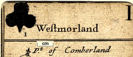
Maps, on playing cards - Westmorland, ace of clubs;
Cumberland, 2 of clubs; and Lancashire, 3 of clubs, by
Robert Morden, 1676; published 1676-80 and 1760s-80s.
Published in 'The 52 Counties of England and Wales, Geographically described in a pack of Cards, Whereunto is added ye Length. Breadth. & Circuit. of each County the latitude the Scituation and distance from London of ye principal Cities, Towns. and Rivers. with other Remarks as plaine and ready for the playing of our English Games as any of ye Common Cards.' 1676. The cards were to be 'Sold by Robert Morden at the Atlas in Cornhill, Will. Berry at the Globe in the Strand, Robert Green in Budge row, and George Minikin at the King's Head in S. Martin's.' The Westmorland playing card has a top panel with the suit mark, a club, stencilled on and the card number a 'I', the ace, this panel has the title 'Westmorland'; a centre panel has a thumbnail map; a bottom panel has geographical information; Length 38, Bredth 33, Circumference 112 etc. This map of Westmorland has roads, and, though minimal, is possibly the earliest road map of the county. There are other editions in 1676; the second edition has the names of the adjacent counties marked on each card. Published in 'A Pocket Book of all the Counties of England and Wales: Wherein are describ'd, the Chief Cities, Market-Towns and others; With the Rivers and Roads from London. To which is added, a Compass, shewing the Bearing, and a Scale for the Distance of Places. There is also given the length, Breadth and Circumference of each County: The Latitude of each City or Town, and its Distance from London. Being a necessary and plain Direction for Travelling to any Place or Town in all England and Wales. Sold by Robert Morden at the Atlas in Cornhill, and Joseph Pask Stationer, at the three Inkbottles in Castle-ally, under the west-end of the Royal Exchange,' London, 1680. The 1680 atlas size is 2 1/2 x 5 7/8 ins, there are two maps on each page, one above the other; the map is the outline map, a panel below gives the advertised data about the county and towns; the suit marks are not included. Published in 'A Brief Description Of England and Wales; Containing A particular Account of each County; With its Antiquities, Curiosities, Situation, Figure, Extent, Climate, Rivers, Lakes, Soils, Agriculture, Civil and Ecclesiastical Divisions, Cities, Towns, Palaces, Corporations, Markets, Fairs, Manufactories, noted Places, Bays, Harbours, Products, &c. and the Number of its Inhabitants. As Also, The Distance of each Market Town from London, by the latest Survey, with the Latitude and Longitude of each County, Town or City, and on what Point of the Compass from London. Embellished with Maps of each County. Very useful for Travellers and others, and very proper for Schools, to give Youth an Idea of Geography, and the Nature of his own Country, and each County. London: Printed for H. Turpin, No.104, St. John's Street, West Smithfield.' about 1773 or 1785. The Turpin edition reprints the 1680 plates plus pages of text, an introduction and text for each county; its size is 2 1/2 x 3 1/2 ins; H Turpin was at 104 St John's Street about 1764-87. The playing cards were copied by John Lenthall, 1717. The playing cards were reproduced in facsimile by Harry Margary, Lympne Castle, Kent, 1972 |
||

|
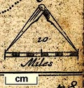
Lenthall 1717 | |
| scale line:- | 10 miles = 5/8 inch | |
| scale:- | 1 to 1000000 ? (1 to 1013760 from scale line) | |
|
||
| references:- |
Morden, Robert: 1680: Pocket Book of all the Counties of
England and Wales: (London) Morden, Robert: 1785 (?): Brief Description of England and Wales: Turpin, H (London) O'Donoghue, F M: 1901: Catalogue of the Collection of Playing-cards Bequeathed to the British Museum by Lady Charlotte Schreiber: (London) Phillips, H D: 1903: Catalogue of the Collection of Playing cards ... formed by Henry D Phillips::: collection in Guildhall Library Wadsworth, F A: 1942: County Maps as Playing Cards: Trans of the Thoroton Society of Nottinghamshire: 45: pp.18-23 |
|
| sources:- |
Chubb 1927 (CVIII) Skelton 1970 Hodson 1984 Armitt Library JandMN Collection |
|
| items seen (illustrated items in bold):- | ||
|
|
Armitt Library : ALMC2008.14.122 -- map -- Westmorland | |
|
|
Armitt Library : ALMC2008.14.123 -- map -- Westmorland | |
|
|
JandMN (99) -- playing cards | |