 Morden 1676

|

|
|
|
item:- Armitt Library : ALMC2008.14.123 image:- © see bottom of page |
click to enlarge |
|
|
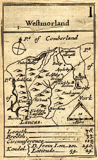
Map, uncoloured engraving, Westmorland, scale about 16
miles to 1 inch, by Robert Morden, 1676, probably published
by Robert Morden, the Atlas, Cornhill, and Joseph Pask, the
Three Inkbottles, Castle Alley, London, 1680.
Included in A Pocket Book of all the Counties of England and Wales. The map was originally the ace of clubs in The 52 Counties of England and Wales, Geographically described in a pack of Cards. There is a little descriptive text about the county:- 'Length ... 38. / Bredth ... 33. / Circumference ... 122. / Kendal D. from Lon. 201. 246. / Latitude ... 54. 24.' |
||

|
Morden 1676 | |
| map feature:- | plain cartouche & compass rose & up is N (roughly, perhaps rotated a little to fit the county in the space) & scale line & dividers & coast shaded & rivers & lakes & relief & hillocks & county & settlements & roads & descriptive text | |
| inscription:- |
printed plain cartouche at the top
Westmorland number I |
|
| inscription:- |
printed with scale line
10 / Miles |
|
| scale line:- | 10 miles = 16.0 mm | |
| wxh, sheet:- | 6.5x10.5cm | |
| wxh, map:- | 58x95mm | |
| scale:- | 1 to 1000000 ? (1 to 1005840 from scale line wrongly assuming statute mile) | |