 Morden 1676

|

|
|
|
item:- Armitt Library : ALMC2008.14.122 image:- © see bottom of page |
click to enlarge |
|
|
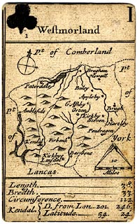
Map, uncoloured engraving on a playing card, Westmorland,
scale about 16 miles to 1 inch, published by Robert Morden,
London, 1676.
The ace of clubs in The 52 Counties of England and Wales, Geographically described in a pack of Cards. The map show roads, '... there is also the Road from London to each Citty or Towne, ...' inserted with the permission of John Ogilby. These are the Lancaster to Carlisle road, and the road from Kendal to Cockermouth. This is possibly the earliest road map of the county; but rather small! There is a little descriptive text about the county:- 'Length ... 38. / Bredth ... 33. / Circumference ... 122. / Kendal D. from Lon. 201. 246. / Latitude ... 54. 24.' |
||

|
Morden 1676 | |
| map feature:- | plain cartouche & compass rose & up is N (roughly, perhaps rotated a little to fit the county in the space) & scale line & dividers & coast shaded & rivers & lakes & relief & hillocks & county & settlements & roads & descriptive text | |
| inscription:- |
printed plain cartouche at the top
Westmorland clubs suit, and number I |
|
| inscription:- |
printed with scale line
10 / Miles |
|
| scale line:- | 10 miles = 16.0 mm | |
| wxh, card and map:- | 57x93mm | |
| scale:- | 1 to 1000000 ? (1 to 1005840 from scale line wrongly assuming statute mile) | |