 Morden 1676

|

|
|
|
item:- JandMN (99) image:- © see bottom of page |
click to enlarge |
|
|
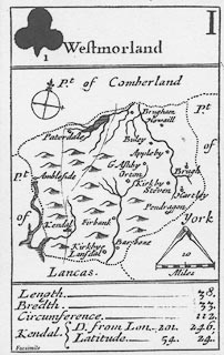
Playing cards, reproduction county maps, by Robert
Morden, London, 1676, published by Harry Margary, Lympne
Castle, Kent, 1972.
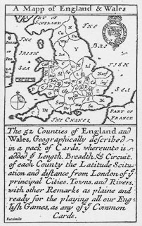
Westmorland is on the ace of clubs, scale about 16 miles to 1 inch; Cumberland is on the deuce of clubs, scale about 25 miles to 1 inch; Lancashire on the tray of clubs, scale about 25 miles to 1 inch; there is a general map of England and Wales with the county outlines. The maps show roads, '... there is also the Road from London to each Citty or Towne, ...' inserted with the permission of John Ogilby. These are possibly the earliest roads maps of the conties; but rather small! |
||

|
Morden 1676 | |
| map feature:- | plain cartouche & compass rose & up is N (roughly, perhaps rotated a little to fit the county in the space) & scale line & sea plain & coast shaded & rivers & lakes (some) & relief & hillocks & county & settlements & roads | |
| inscription:- |
printed plain cartouche at the top
Westmorland clubs suit, and number I |
|
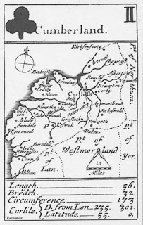
| inscription:- |
printed plain cartouche at the top
Cumberland clubs suit, and number II |
|
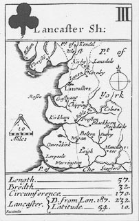
| inscription:- |
printed plain cartouche at the top
Lancashire clubs suit, and number III |
|
| scale line:- | 10 miles = 15.8 mm (about) | |
| scale line:- | 10 miles = 10.3 mm (about) | |
| scale line:- | 10 miles = 10.2 mm (about) | |
| scale:- | 1 to 1000000 ? (1 to 1018572 from scale line on facsimile, wrongly assuming statute mile) | |
| scale:- | 1 to 1600000 ? (1 to 1562470 from scale line on facsimile, wrongly assuming statute mile) | |
| scale:- | 1 to 1600000 ? (1 to 1577788 from scale line on facsimile, wrongly assuming statute mile) | |
|
||
|
||
|
||
|
|
notes | |