 Moll 1724

|

|
|
|
map type:- Moll 1724 |
|
|
|
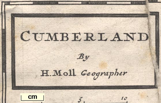
Maps, Westmorland, scale about 5.5 miles to 1 inch, and
Cumberland, scale about 7 miles to 1 inch, by Herman Moll,
London, 1724; published 1724-53.
There are corresponding maps of other counties. Published in 'A New Description Of England and Wales, With the Adjacent Islands. Wherein are contained, Diverse useful Observations and Discoveries In respect to Natural History, Antiquities, Customs, Honours, Privileges, &c. With a Particular Account of the Products, Trade, and Manufactures of the respective Places in every County, and their Improvements or Decays. Together with Many uncommon Observations concerning Mines of several sorts. Also, Several Errors of different kinds are Rectified. The whole illustrated with many Historical and Critical Remarks. To which is added, A new and correct Set of Maps of each County, their Roads and Distances; and, to render 'em the more acceptable to the Curious, their Margins are adorn'd with great Variety of very remarkable Antiquities, &c. By Herman Moll, Geographer. London: Printed for H. Moll over-against Devereux-Court in the Strand, T. Bowles Printseller near the Chapter-House, and C. Rivington Bookseller at the Bible and Crown, in St. Paul's Church-yard, and J. Bowles Printseller over-against Stocks-Market. M.DCC.XXIV.' ie 1724. The atlas has a title page and about 30 pages of text, and an index; the authorship of the text is unknown, based on Camden's Britannia; the atlas size is 6 1/4 x 10 1/2 ins; the map is plain on the reverse, versions exist with and without plate numbers; it is said to be based on Speed with the coast line from Joseph Avery's chart of 1722 (Hodson). Moll adjusted [fudged] his county boundaries, the preface:- '... you have a new Set of very fair Maps, wherein no Art nor Industry have been wanting to lay down the Places exactly in their proper Longitudes and Latitudes, so that the Distances of them are much rectified and improved, by the careful Perusal of several valuable and exact Surveys; and this will the more plainly appear, by examining the County Maps hitherto extant, whose Positions are so various and irregular, the frontiers of the adjacent Counties by no means agree with one another; whereas in this new set, the upper Part of each Map, except Cornwall, is directly North; and they are so regularly and methodically disposed, as to agree, and all join exactly one with another, and to make it as it were but one continued Map of the whole Kingdom.' Published in 'A Set of Fifty New and Correct Maps Of England and Wales, &c. with The Great Roads and Principal Cross-Roads, &c. Shewing the Computed Miles from Town to Town. A Work long wanted, and very useful for Gentlemen that Travel to any Part of England. All, except two, composed and done by Herman Moll, Geographer ... And, to render this Work more acceptable to the Curious, the Margins of each Map are adorn'd with great Variety of very remarkable Antiquities. London: Sold by H. Moll over-against Devereux-Court in the Strand; Tho. Bowles, Print and Map-Seller near the Chapter-House in St. Paul's Church-Yard, and J. Bowles Print and Map-Seller over against Stocks-Market. 1724.' The atlas size is 10 1/2 x 6 1/4 ins, it is a reprint without text; the map is unchanged, but does have a plate number between brackets within the top left border. Perhaps published in weekly parts '... Printed for J. Wilford, behind the Chapter-house; T. Bowles print-seller, and C. Rivington, bookseller, in St. Paul's Church-yard; and J. Bowles print-seller, in Cornhill. MDCCXXXIII.' ie 1733. It is possible that this publication is the source of maps that have been printed back to back on one sheet. Published in 'A New Description Of England And Wales, ... With A Particular Account of the Products, Trade, and Manufactures of the respective Places in every County, and their Improvements and Decays. ... Also several Errors of different kinds are Rectified. To which is added, A new and correct Set of Maps of each County ... London: Printed for J. Wilford, behind the Chapter-house, T. Bowles Printseller, and C. Rivington Bookseller, in St. Paul's Church-yard; and J. Bowles Printseller, in Cornhill. MD CCXXXIII.' ie 1743. Published in 'A Set of Fifty New and Correct Maps of the Counties of England and Wales, &c. ... London: Printed for, and Sold by Tho: Bowles, Print and Map Seller, near the Chapter-House in St. Paul's Church-Yard; and J. Bowles, Print and Map Seller, at the Black Horse, Cornhill, 1739.' Published in another edition 'The Geography of England and Wales, ...' by Thomas and J Bowles, 1747. The atlas is much the same although the title is changed; the map is unchanged in editions of 1739 and 1747. Published in 'H. Moll's British Atlas, or Pocket Maps of all the Counties of England and Wales. In which are laid down All the Great Roads, and the Principal Cross Roads in each County, with the Distances from Town to Town. Composed and Engraved by Herman Mill, Geographer; And lately revised and improved, with the Addition of many Hundred Places, by Emanuel Bowen, Geographer to His Majesty, ... London: Printed for Tho. Bowles, near the Chapter House in St. Paul's Church Yard; and J. Bowles and Son, at the Black Horse in Cornhill. MDCCLIII. ...' ie 1753. The map is amended by Emanuel Bowles; the copper plates are cut down so that the marginal information on antiquities etc is gone; a few roads are added and the mileage figures increased to be Ogilby's measured miles instead of the computed miles; etc? Published in 'The Traveller's Companion; Or, A Complete Set Of Maps Of All The Counties In England And Wales: Laid down from the latest Surveys, and other best Authorities. Distinctly shewing the Cities, Towns, and chief Villages, the Rivers, Sea-Coasts, and Harbours. And being designed for Use in Travelling, all the Great Roads, and principal Cross Roads, are particularly described. Composed by Herman Moll, Geographer. Revised and improved by Emanuel Bowen, Geographer to his Majesty. The Counties are placed in Alphabetical Order, viz. ... London: printed for John Bowles at No.13 in Cornhill.' about 1766. Using very old plates, Moll amended by Bowen, this atlas was, perhaps, not very successful. The map has an additional plate number, in brackets? top right. |
||

|
Rocque 1746 | |
| see:- | Simpson 1746 | |
|
(example map Dove Cottage : 2007.38.1)
|
||
| map feature:- | title cartouche & plain cartouche & up is N & scale line & lat and long scales (W from London, trapezoid projection) & sea plain & coast shaded & rivers & lakes & relief & hillocks & woods & trees & forests & parks & county & settlements & roads | |
| inscription:- |
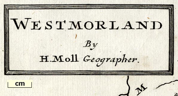
printed title cartouche, upper left
WESTMORLAND / By / H. Moll Geographer. |
|
| wxh, sheet:- | 34x21.5cm | |
| wxh, plate:- | 324x206mm | |
| wxh, map:- | 256x193mm | |
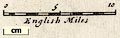
| scale line:- | 10 miles = 44.9 mm | |
| scale:- | 1 to 360000 ? (1 to 358429 from scale line assuming a statute mile) | |
|
||
|
||
| references:- |
Moll, Herman: 1724: New Description of England and Wales:
Moll, Herman & Bowles, T & Rivington, C & Bowles, J
(London) Moll, Herman: 1724: Set of Fifty New and Correct Maps of England and Wales: Moll, Herman & Bowles, Thomas & Bowles, J (London) Moll, Herman: 1733: New Description of England and Wales: Wilford, J & Bowles, T & Rivington, C & Bowles, J (London) Moll, Herman: 1739: Set of Fifty New and Correct Maps of England and Wales: Bowles, Thomas & Bowles, J (London) Mill, Herman: 1747: Geography of England and Wales: Bowles, Thomas & Bowles, J Moll, Herman: 1753: Moll's British Atlas & Pocket Maps of all the Counties of England and Wales: (London) Moll, Herman & Bowles, Emanuel: 1766: Traveller's Companion & Complete Set of Maps of all The Counties In England And Wales: Bowles, John (London) Defoe, Daniel: 1927 (edition): Tour through the whole Island of Great Britain: (London): 2 vols: includes reduced copies of Molls maps |
|
| sources:- |
Chubb 1927 (CLX) Hodson 1984 Wordsworth Trust Collection Carlisle Library Maps Kendal Library Maps |
|
| items seen (illustrated items in bold):- | ||
|
|
Armitt Library : ALMC2008.14.19 -- map -- Westmorland | |
|
|
Armitt Library : ALMC2008.14.20 -- map -- Westmorland | |
|
|
Armitt Library : ALMC2008.14.21 -- map -- Westmorland | |
|
|
Carlisle Library : Map 14 -- map -- Cumberland | |
|
|
Dove Cottage : 2007.38.1 -- map -- Westmorland | |
|
|
Kendal Library : Map 34 -- map -- Westmorland | |
|
|
Kendal Library : Map 63 -- map -- Westmorland | |
|
|
Kendal Library : Map 64 -- map -- Westmorland | |
|
|
private collection (29) -- map -- Cumberland | |
|
|
private collection (175) -- map -- North Riding of York Shire | |