 Moll 1724

|

|
|
|
item:- private collection (175) image:- © see bottom of page |
click to enlarge |
|
|
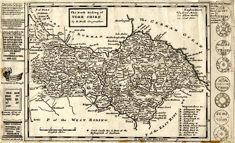
Map, uncoloured engraving, The North Riding of York
Shire, scale about 8 miles to 1 inch, by Herman Moll,
London, about 1724.
In the page margins, left and right of the map, are illustrations of antiquities; roman inscriptions on the left, and coins on the right 'Sancta Petri Moneta or St. Peters Pence are Saxon Coins and Struck at York'. Plate 44 from A New Description Of England and Wales, With the Adjacent Islands, or a later edition. |
||

|
Moll 1724 | |
| map feature:- | plain cartouche & up is N & scale line & lat and long scales (W from London, trapezoid projection) & sea plain & coast shaded & rivers & relief & hillocks & woods & forests & parks & county & settlements & roads | |
| inscription:- |
printed title cartouche, upper left of centre
The North Riding of / YORK SHIRE / By H. Moll Geographer. |
|
| scale line:- | 15 miles = 49.0 mm | |
| wxh, sheet:- | 32x19.5cm | |
| wxh, map:- | 255x191mm | |
| scale:- | 1 to 490000 ? (1 to 492656 from scale line assuming a statute mile) | |