 Moll 1724

|

|
|
|
item:- Dove Cottage : 2007.38.1 image:- © see bottom of page |
click to enlarge |
|
|
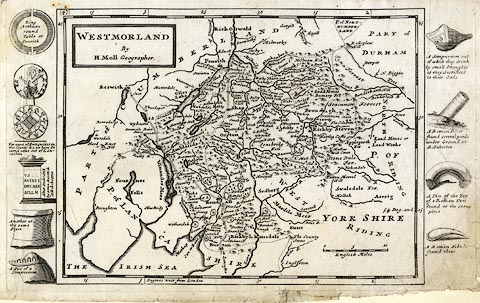
Map, uncoloured engraving, Westmorland, scale about 5.5
miles to 1 inch, by Herman Moll, London, about 1724.
In the page margins, left and right of the map, are illustrations of antiquities, examples - a plan of Arthur's Round Table at Penrith, and a coin, from Westmorland; and the remark 'For want of Antiquities in this County &c. we have Inserted some out of Lancashire' Plate 47 from A New Description Of England and Wales, With the Adjacent Islands, or a later edition. |
||

|
Moll 1724 | |
| map feature:- | plain cartouche & up is N & scale line & lat and long scales (W from London, trapezoid projection) & sea plain & coast shaded & rivers & lakes & relief & hillocks & woods & forests & parks & county & settlements & roads | |
| inscription:- |
printed title cartouche, upper left
WESTMORLAND / By / H. Moll Geographer. |
|
| inscription:- |
printed with scale line
English Miles |
|
| scale line:- | 10 miles = 44.9 mm | |
| wxh, sheet:- | 34x21.5cm | |
| wxh, plate:- | 324x206mm | |
| wxh, map:- | 256x193mm | |
| scale:- | 1 to 360000 ? (1 to 358429 from scale line assuming a statute mile) | |