 Moll 1724

|

|
|
|
item:- Armitt Library : ALMC2008.14.21 image:- © see bottom of page |
click to enlarge |
|
|
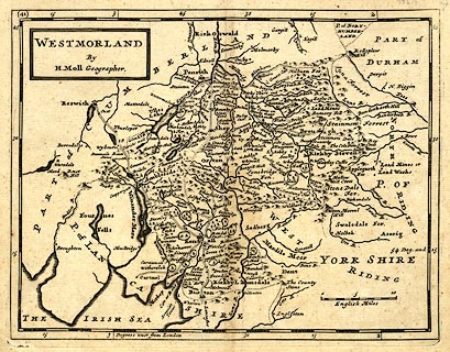
Map, uncoloured engraving, Westmorland, scale about 5.5
miles to 1 inch, by Herman Moll, London, about 1724, edn
1753.
Included in H. Moll's British Atlas, or Pocket Maps of all the Counties of England and Wales, published by T Bowles and .J Bowles and Son, London, 1753. The map is amended by Emanuel Bowles; the copper plates are cut down so that the marginal information on antiquities etc is gone; a few roads are added and the mileage figures increased to be Ogilby's measured miles instead of the computed miles; etc? The plate is renumbered 41. |
||

|
Moll 1724 | |
| map feature:- | plain cartouche & up is N & scale line & lat and long scales (W from London, trapezoid projection) & sea plain & coast shaded & rivers & lakes & relief & hillocks & woods & forests & parks & county & settlements & roads | |
| inscription:- |
printed title cartouche, upper left
WESTMORLAND / By / H. Moll Geographer. |
|
| scale line:- | 10 miles = 44.7 mm | |
| wxh, sheet:- | 27.5x22.5cm | |
| wxh, plate:- | 257x208mm | |
| wxh, map:- | 254x195mm | |
| scale:- | 1 to 360000 ? (1 to 360032 from scale line assuming a statute mile) | |