 Westmorlandia, Lancastria, Cestria etc

|

|
|
|
map type:- Mercator 1595 |
|
|
|
Maps, table 3 - Westmorlandia, Lancastria, Cestria etc,
and table 2 - Northumbria, Cumberlandia, Dunelm Episcopi,
scales roughly 10 miles to 1 inch, by Gerard Mercator,
Duisberg, Germany, 1595; published 1590s-1640s.
The maps are two of five regional maps of Britain originally in an edition of the Mercator's Atlas of the World, 'Atlantis Pars Altera Geographia Nova Totius Mundi, Authore Gerardo Mercatore ... Duysburgi ...'. The second issue of the atlas was 'Atlas sive Cosmographicae Meditationes de Fabrica Mundo et Fabrica Figura. Gerardo Mercatore ... Duisberg', which became the standard title. The atlas is often referred to as the Mercator Atlas. Jodocus Hondius bought the plates 1604, probably from the grandson of Geradus Mercator to produce a new editions of the Mercator Atlas from 1606 onwards. There were editions in French, Germans, Dutch, and English, the last with an altered map. The atlas was published latterly by Jan Jansson and Henry Hondius son of Jodocus. Clues for identification of the exact edition are - the exact wording of the title, the language of the text on the back, the page numbers of the text or their absence, and the signature letter if there is one. |
||

|
Hondius 1607 | |
|
(example map Armitt Library : ALMC2008.14.3)
|
||
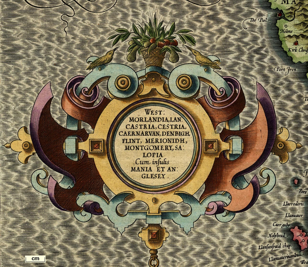
| map feature:- | title cartouche & scroll cartouche & swash lettering (sea area labels) & labelled borders (Latin) & up is N & scale line & lat and long scales (rectangular projection?) & sea moire effect & sea monsters & coast shaded & rivers & lakes & relief & hillocks & woods & trees & county & settlements | |
| inscription:- |
printed title cartouche, left
WEST : / MORLANDIA, LAN : / CASTRIA, CESTRIA, / CAERNARVAN, DENBIGH, / FLINT, MERIONIDH, / MONTGOMERY, SA : / LOPIA / Cum insulis / MANIA ET AN : / GLESEY. |
|
| inscription:- |
printed lower left
Per Gerardum Mercatorem / Cum Privilegio |
|
| wxh, sheet:- | 56.5x48cm | |
| wxh,:- | 419x363mm | |
| wxh,:- | 415x359mm | |
| inscription:- |
printed below scale line, below title cartouche
Miliaria Mediocria Angliae. |
|
| scale line:- | 20 miles = 48.2 mm | |
| scale:- | 1 to 670000 ? (1 to 667778 from scale line, wrongly assuming a statute mile) | |

|
||
| references:- |
Keunig, J: 1947: History of an Alas, Mercator-Hondius: Imago
Mundi: vol.4: pp.37-62 Koeman & van den Krogt, Peter: 1997: Koeman's Atlantes Neerlandici, New Edition: HES Publishers (Netherlands):: ISBN 0 06194 248 9 (3 vol. set); this work is essential for identifyng the edition of a map. Shirley, Rodney W: 1980 (revised edn): Early Printed Maps of the British Isles 1477-1650: Antique Atlas Publications (East Grinstead, West Sussex):: ISBN 0 9514914 2 3 |
|
| sources:- |
Armitt Library JandMN Collection Kendal Library Maps |
|
| items seen (illustrated items in bold):- | ||
|
|
Armitt Library : ALMC2008.14.2 -- map -- Westmorlandia, Lancastria, Cestria etc -- Westmorland, Lancashire, Cheshire etc | |
|
|
Armitt Library : ALMC2008.14.3 -- map -- Westmorlandia, Lancastria, Cestria etc -- Westmorland, Lancashire, Cheshire etc | |
|
|
JandMN (169) -- map -- Northumbria, Cumberlandia, et Dunelmensis Episcopatus | |
|
|
Kendal Library : Map 116 -- map -- Northumbria, Cumberlandia, et Dunelmensis Episcopatus | |
|
|
National Library of Scotland : EMW.b.2.40 -- atlas -- Historia Mundi or Mercator's Atlas -- Mercator's Atlas, Historia Mundi or | |