 Mercator 1595

|

|
|
|
item:- Armitt Library : ALMC2008.14.3 image:- © see bottom of page |
click to enlarge |
|
|
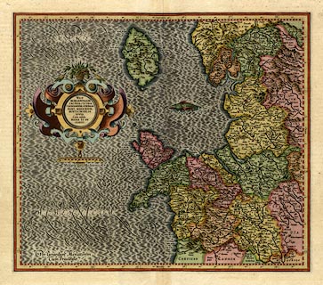
Map, hand coloured engraving, Westmorlandia, Lancastria,
Cestria etc, ie Westmorland, Lancashire, Cheshire etc, scale
about 10.5 miles to 1 inch, by Gerard Mercator, Duisberg,
Germany, 1595, edition 1613-16.
The map is one of five regional maps of Britain originally in an edition of the world atlas, 'Atlantis Pars Altera Geographia Nova Totius Mundi, Authore Gerardo Mercatore ... Duysburgi ...' Jodocus Hondius and Cornelius Claesz obtained the copper plates, probably from the grandson of Geradus Mercator to produce a new edition of the Mercator Atlas in 1606 with partly new text by Petrus Montanus. French editions were issued 1609, 1613-16, 1619, 1628, 1633. The descriptive text on the reverse, pp.73-74, is in French, headed 'LA III TABLE D'ANGLETERRE: ...' which identifies it as coming from the French edition 1613-16. |
||

|
Mercator 1595 | |
| map feature:- | scroll cartouche & swash lettering (sea areas labels) & labelled borders (Latin) & up is N & scale line & lat and long scales (rectangular projection?) & sea moire effect & sea monsters & coast shaded & rivers & lakes & relief & hillocks & woods & county & settlements | |
| inscription:- |
printed title cartouche, left
WEST : / MORLANDIA, LAN : / CASTRIA, CESTRIA, / CAERNARVAN, DENBIGH, / FLINT, MERIONIDH, / MONTGOMERY, SA : / LOPIA / Cum insulis / MANIA ET AN : / GLESEY. |
|
| inscription:- |
printed lower left
Per Gerardum Mercatorem / Cum Privilegio |
|
| inscription:- |
printed below scale line, below title cartouche
Miliaria Mediocria Angliae. |
|
| scale line:- | 20 miles = 48.2 mm | |
| wxh, sheet:- | 56.5x48cm | |
| wxh, plate:- | 419x363mm | |
| wxh, map:- | 415x359mm | |
| scale:- | 1 to 670000 ? (1 to 667778 from scale line, wrongly assuming a statute mile) | |
|
|
notes | |