 Mercator 1595

|

|
|

|
back to object record | |
| Map Features | ||
|
|
||
| title cartouche |
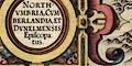
Printed in a title cartouche, upper left, N sheet:- NORTH- / UMBRIA, CUM- / BERLANDIA, ET / DUNELMENSIS / Episcopa: / tus. In a title cartouche on the left, S sheet:- WEST: / MORLANDIA, LAN: / CASTRIA, CESTRIA, / CAERNARVAN, DENBIGH, / FLINT, MERIONIDH, / MONTGOMERY, SA: / LOPIA / Cum insulis / MANIA ET AN: / GLESEY. Printed on each, lower:- Per Gerardum Mercatorem / Cum Privilegio |
|
|
|
||
|
orientation
labelled borders |
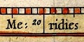
The maps borders are labelled, in Latin:- Septentrio / Oriens / Meridies / Occidens The map is printed with North at the top of the sheet. |
|
|
|
||
|
scale line
scale |
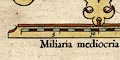
The N map has a scale line below the title cartouche, upper left, labelled:- Miliaria mediocria Angliae. Middling English miles. The scale line of 20 miles = 80.2 mm gives a map scale 1 to 401333 wrongly assuming a statute mile. The N map scale is about:- 1 to 400000 6.5 miles to 1 inch The similar scale line on the S sheet is 20 miles = 48.2 mm giving a map scale 1 to 667778 wrongly assuming a statute mile. The S map scale is about:- 1 to 670000 10.5 miles to 1 inch |
|
|
|
||
| lat and long scales |
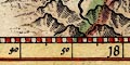
In the map borders are scales of latitude and longitude for a rectangular projection; chequered in minutes, labelled at 10 minute intervals. The longitude reads from a prime meridian in the West. Reading from the scales the longitude, Carlisle = 17d 15m E this suggests a prime meridian 20 degrees west of Greenwich, somewhere about the Canary Islands or the Azores. |
|
|
|
||
|
sea area
sea wave effect swash lettering |
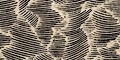
The sea area is engraved with patches of curved shading that interlock to give an impression of waves. The Irish Sea is labelled in swash lettering:- 
MARE HIBERNICUM also labelled is:- Solway Fryth |
|
|
|
||
|
coast line
coast shaded foreshore |
The coast line is emphasized by shading, and tinted blue. Foreshore sands are indicated by areas of dotting in the Solway Firth and all round Morecambe Bay. |
|
|
|
||
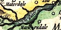
|
rivers
bridges |
Rivers are drawn by a double line, perhaps with stream lines. Some rivers are labelled, eg:- Lune flu. Eden flu. Trout bek Some bridges are marked by a double line crossing and interrupting a stream. For example at Kirkby Lonsdale. 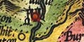
|
|
|
|
||
| lakes |
Lakes are drawn by an outline with shading to emphasize the shore line. Some lakes are labelled:- Uls Water Winander mere Other lakes might be recognized, eg:- Bassenthwaite Lake Brothers Water Burnmoor Tarn Buttermere lake Coniston Water Crummock Water Derwent Water Devoke Water Ennerdale Water Grasmere lake Loweswater lake Thirlmere Wast Water |
|
|
|
||
|
relief
hillocks |
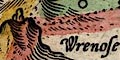
Relief is indicated by hillocks, shaded to the east.
These are grouped somewhat, to show a mountainous lakeland
region and the Pennines, and, by absence, the Eden Valley,
etc. Some hillocks are larger, more knobbly; some hillocks
might be labelled, eg:-
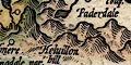
Helvillon hill Wrenose hill [with stones on top] |
|
|
|
||
|
woods
forests |
Large tree symbols indicate woodland. Some groups of
trees are labelled as forests, eg:-
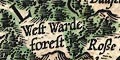
West Warde forest Copeland forest |
|
|
|
||
| county |
County boundaries are a dotted line. On the maps studied the boundary is emphasized by a tint for each county: (N sheet) Cumberland yellow, Westmorland green, Northumberland red, Durham Green, Yorkshire red; (S sheet) Cumberland yellow, Westmorland green, Durham green, Yorkshire red, Lancashire N of the sands orange, Lancashire yellow. The example of the S sheet studied has each county tinted with a pale wash of the colour. County areas are labelled, eg:- WESTMORLANDIA CUMBERLANDIA LANCASTRIA |
|
|
|
||
| settlements |
Settlements are marked by a circle with added elements,
but not differentiated by style of labelling.
|
|
| cities |
circle, buildings and towers, one with a cross; labelled
in lowercase italic text, eg:-
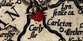
Carlysle tinted red. |
|
| towns |
circle, buildings and towers, or just towers ; labelled
in lowercase italic text, eg:-
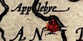
Applebye Kendall Penreathe |
|
|
tinted red.
|
||
|
villages
hamlets |
circle; labelled in lowercase italic text, eg:-
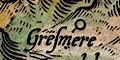
Gresmere Cumrew Orton Barton Some circles have a short line attached, which seems to lead to its label. |
|
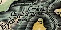
| castles |
circle, tower or two towers; labelled in lowercase italic
text, eg:-
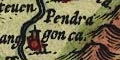
Pendragon ca. Daker ca. |
|
|
|
||
| miscellaneous | ||
|
|
||
|
antiquities
roman wall |
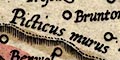
Hadrian's Wall is marked by a dotted line and fence palings, tinted brown, running from Boulness, through Carlysle, then north and east across Northumberland. It is labelled:- Murus Picticus |
|
|
|
||
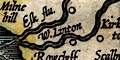
| mines |
What could be taken for an adit entrance on the side of a
hillock marks a mine in the Caldbeck Fells, labelled:-
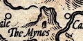
The Mynes |
|
|
|
||
| stones |
The Three Shire Stones are marked on Wrenose hil.
|
|
Lakes Guides menu.