 Mercator 1595

|

|
|
|
item:- JandMN (169) image:- © see bottom of page |
click to enlarge |
|
|
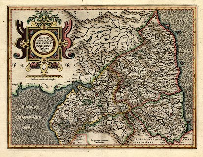
Map, hand coloured engraving, Northumbria, Cumberlandia,
et Dunelmensis Episcopatus, ie Northumberland, Cumberland
and Durham etc, scale about 6.5 miles to 1 inch, by Gerard
Mercator, Duisberg, Germany, about 1595.
The map is one of five regional maps of Britain originally in an edition of the world atlas, 'Atlantis Pars Altera Geographia Nova Totius Mundi, Authore Gerardo Mercatore ... Duysburgi ...' The text on the reverse is pp.65,66 in Latin, headed 'ANGLIAE II TABULA Quae continet Northumbriam, Cumberlandiam Cmitatus & Dunelmensem Episcopatum.' |
||

|
Mercator 1595 | |
| map feature:- | strapwork cartouche & swash lettering (sea areas labels) & labelled borders (Latin) & up is N & scale line & lat and long scales (rectangular projection?) & sea wave effect & coast shaded & rivers & lakes & relief & hillocks & woods & forests & county & settlements | |
| inscription:- |
printed title cartouche, upper left
NORTH- / UMBRIA, CUM- / BERLANDIA, ET / DUNELMENSIS / Episcopa : / tus. |
|
| inscription:- |
printed lower centre
Per Gerardum Mercatorem / Cum Privilegio |
|
| inscription:- |
printed below scale line, below title cartouche
Miliaria mediocria Angliae. |
|
| scale line:- | 20 miles = 80.2 mm | |
| wxh, sheet:- | 55.5x45.5cm | |
| wxh, plate:- | 469x353mm | |
| wxh, map:- | 465x349mm | |
| scale:- | 1 to 400000 ? (1 to 401333 from scale line, wrongly assuming a statute mile) | |
|
||
|
||
|
|
notes | |