 Mercator 1595

|

|
|
|
item:- Armitt Library : ALMC2008.14.2 image:- © see bottom of page |
click to enlarge |
|
|
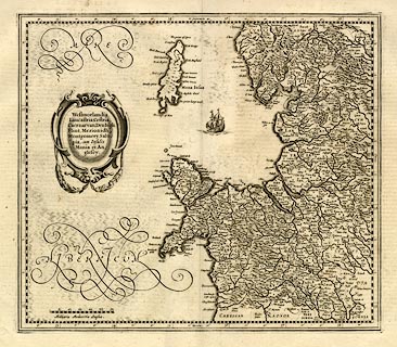
Map, uncoloured engraving, Westmorlandia, Lancastria,
Cestria etc, ie Westmorland, Lancashire, Cheshire etc, scale
about 10.5 miles to 1 inch, by Gerard Mercator, Duisberg,
Germany, 1595, edition altered and published by Henry
Hondius and John Jansson, 1639-42.
The map is one of five regional maps of Britain originally in an edition of the world atlas, 'Atlantis Pars Altera Geographia Nova Totius Mundi, Authore Gerardo Mercatore ... Duysburgi ...' The descriptive text on the reverse, no page numbers, signature letter T, is in French, headed 'LA III. TABLE D'ANGLETERRE ...' which identifies it as coming from the Nouveau Theatre du Monde, published by Henricus Hondius and by Johannes Janssonius, 1639-42. Areas of moire effect sea have been erased on the original copper plate; the swash lettering is repaired in places, for example the tail of the I of Hibernicum; there is a new title cartouche; a galleon replaces the sea monster of the original; a new scale line replaces the name of Mercator; the Isle of Man is engraved with a new, and worse? outline. |
||

|
Mercator 1595 | |
| map feature:- | scroll cartouche & swash lettering (sea areas labels) & labelled borders (Latin) & up is N & scale line & lat and long scales (rectangular projection?) & sea moire effect (partly erased on the plate) & galleons (replaces a sea monster) & coast shaded & rivers & lakes & relief & hillocks & woods & county & settlements | |
| inscription:- |
printed title cartouche, left
Westmorlandia / Lancastrai, Cestria, / Caernarvon, Denbigh, / Flint, Merionidh, / Montgomery, Salo : / pia, cum Insulis / Mania et An : / glesey. |
|
| inscription:- |
printed below scale line, lower left
Milliaria Mediocria Angliae. |
|
| scale line:- | 30 miles = 72.6 mm | |
| wxh, sheet:- | 58.5x49.5cm | |
| wxh,:- | 417x364mm | |
| wxh,:- | 410x360mm | |
| scale:- | 1 to 670000 ? (1 to 665018 from scale line, wrongly assuming a statute mile) | |