 Westmorland, Castria, Cestria etc

|

|
|
|
map type:- Hondius 1607 |
|
|
|
Maps, table 3 - Westmorland, Castria, Cestria etc, and
table 2 - Northumbria, Cumberlandia, Dunelm Episcopi, scales
roughly 20 miles to 1 inch, engraved in reduced versions by
Jodocus Hondius about 1607 from the maps of Gerard Mercator
1595; published 1608-1621, re-engravd by Peter Keer,
published 1620s-40s.
The maps are two of five regional maps of Britain for an 'Atlas Minor Gerardi Mercatori ...', the Atlas Minor, published by Jodocus Hondius, Amsterdam, Netherlands, 1607.. Jodocus Hondius engraved miniature versions of Mercator's maps which were published from 1607; editions in Latin, French, German. The small plates were sold to England in 1621, used for editions in English, for example in 'Purchas his Pilgrims' 1625 and 'Historia Mundi or Mercators Atlas' 1635-39. There were later editions using plates re-engraved by Peter Keer published by Jan Jansson from 1628, and by Jan Cloppenberg from 1630. Clues for identification of the exact edition are - the exact wording of the title, the language of the text on the back, the page numbers of the text or their absence, and the signature letter if there is one. |
||

|
Mercator 1595 | |
|
|
Hondius 1616 | |
|
(example Armitt Library : ALMC2008.14.14)
|
||
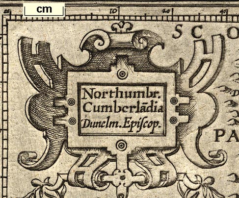
| map feature:- | title cartouche & strapwork cartouche & scale line & labelled borders (Latin) & up is N & lat and long scales (rectangular projection, E from somewhere in the Atlantic) & sea pecked & galleons & sea monsters & rivers & lakes & relief & hillocks & county & settlements | |
| inscription:- |
printed title cartouche, upper left
Northumbr. / Cumberla~dia / Dunelm.Eopiscop. |
|
| inscription:- | printed top right of page (the map is sideways), page number 89 | |
| inscription:- |
printed top of page
THE SECOND TABLE / OF / ENGLAND. |
|
| wxh, sheet:- | 18.5x28.5cm | |
| wxh, map:- | 186x131mm | |
| scale:- | 1 to 1300000 ? (1 to 1297858 from scale line wrongly assuming a statute mile) | |
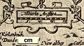
| inscription:- |
printed above scale line, left
Miliaria Anglica |
|
| scale line:- | 20 miles = 24.8 mm | |
|
||
| references:- |
Keunig, J: 1947: History of an Alas, Mercator-Hondius: Imago
Mundi: vol.4: pp.37-62 Koeman & van den Krogt, Peter: 1997: Koeman's Atlantes Neerlandici, New Edition: HES Publishers (Netherlands):: ISBN 0 06194 248 9 (3 vol. set); this work is essential for identifyng the edition of a map. Shirley, Rodney W: 1980 (revised edn): Early Printed Maps of the British Isles 1477-1650: Antique Atlas Publications (East Grinstead, West Sussex):: ISBN 0 9514914 2 3 |
|
| sources:- |
Armitt Library |
|
| items seen (illustrated items in bold):- | ||
|
|
Armitt Library : ALMC2008.14.13 -- map -- Westmorlandia, Lancastria, Cestria ... -- Westmorland, Lancashire, Cheshire ... -- Angliae III Tabula | |
|
|
Armitt Library : ALMC2008.14.14 -- map -- Northumbria, Cumberlandia, Dunelm Episcopi -- Northumberland, Cumberland, Durham | |
|
|
Armitt Library : ALMC2008.14.15 -- map -- Lancastria, Cestria ... -- Lancashire, Cheshire ... | |