 Hondius 1607

|

|
|
|
item:- Armitt Library : ALMC2008.14.14 image:- © see bottom of page |
click to enlarge |
|
|
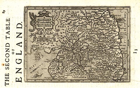
Map, uncoloured engraving, Northumbria, Cumberlandia,
Dunelm Episcopi ie Northumberland, Cumberland, Durham, which
is England plate 2, scale about 20.5 miles to 1 inch,
engraved by Jodocus Hondius 1607, from a larger map by
Gerard Mercator 1595, published by Michael Sparke, and
Samuel Cartwright, London, 1635-39.
The map is printed sideways on the page. The text on the reverse, page 90, is in English, the map is on page 89 with signature letter I3, which identifies the map as coming from the Historia Mundi or Mercator's Atlas, 1635-39 published by Sparke and Cartwright. The map was engraved by Jodocus Hondius 1607, from the larger map by Gerard Mercator 1595, for Mercator's Atlas Minor published by Jodocus Hondius; the plates were sold to England aboout 1621-25 and used in various works. |
||

|
Hondius 1607 | |
| map feature:- | strapwork cartouche & scale line & labelled borders (Latin) & up is N & lat and long scales (rectangular projection, E from somewhere in the Atlantic) & sea stippled & galleons & sea monsters & rivers & lakes & relief & hillocks & county & settlements | |
| inscription:- |
printed title cartouche, upper left
Northumbr. / Cumberla~dia / Dunelm.Episcop. |
|
| inscription:- | printed top right of page (the map is sideways), page number 89 | |
| inscription:- |
printed top of page
THE SECOND TABLE / OF / ENGLAND. |
|
| inscription:- |
printed above scale line, left
Miliaria Anglica |
|
| scale line:- | 20 miles = 24.8 mm | |
| wxh, sheet:- | 18.5x28.5cm | |
| wxh, map:- | 186x131mm | |
| scale:- | 1 to 1300000 ? (1 to 1297858 from scale line wrongly assuming a statute mile) | |
|
|
notes | |
|
|
notes | |