 Hondius 1607

|

|
|

|
back to object record | |
| MAP FEATURES | ||
|
The notes are biased towards an interest in Westmorland and
Cumberland; features elsewhere might be ignored.
|
||
|
|
||
|
title cartouche
strapwork cartouche |
Each map has a title in a strapwork cartouche, but also
has a page number and title on the sheet. The page title is
oriented with the page: the map is sideways on the page.
Plate 2: printed upper left:- 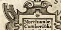
Northumbr. Cumberla~dia Dunelm.Episcop. Printed top of the page:- 89 / THE SECOND TABLE OF ENGLAND. Plate 3: printed left above centre:- WESTMORLAND, CASTRIA, CESTRIA etc Printed top of the page:- 93 / THE THIRD TABLE OF ENGLAND. |
|
|
|
||
|
orientation
labelled borders up is N |
The map borders have labels in Latin:-
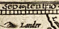
Septentrio / Oriens / Meridies / Occidens The ma is printed with North at the top of the sheet as defined by the labelling. The map is sideways on the page, bottom towards the spine of the book. |
|
|
|
||
|
scale line
scale |
Plate 2 has a scale line printed below the title on the
left:-
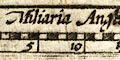
Miliaria Anglica chequered in miles, labelled in fives. The 20 miles = 24.8 mm gives a map scale 1 to 1297858 wrongly assuming a statute mile. The map scale is about:- 1 to 1300000 21 miles to 1 inch |
|
|
|
||
| lat and long scales |
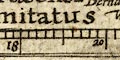
Printed in the map borders, plate 2, are scales of latitude and longitude for a rectangular projection; marked at 6 minutes intervals ie tenths of a degree, labelled at degrees. Longitude is measured from a prime meridian well into the Atlantic. From the scales of plate 3 the longitude, Kendal = 17d 24m E suggesting a prime meridian about 20d 9m W of Greenwich, roughly in the Canary Islands. The latitude and longitude scales on plate 3 are labelled at 10 minute intervals, labelled at degrees. Plate 2 includes Northumberland, Durham, the north of Cumberland, north of Westmorland, part of Yorkshire, and some of the border lands of Scotland. Plate 3 includes the south of Cumberland, Westmorland, Lancashire, Cheshire, part of Yorkshire, parts of Staffordshire and Shropshire, north of Wales, and the Isle of Man. |
|
|
|
||
|
sea area
sea moire effect sea pecked sea monsters galleons sandbanks swash lettering |
Sea areas on the two maps are engraved differently. Plate 2 has the sea pecked; plate 3 has a moire effect. The Irish Sea is labelled:- MARE HIBERNICUM in block caps on plate 2, in swash lettering on plate 3. 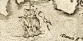
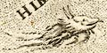
Both plates have a galleon: flat stern on which the rudder is mounted; sprit with a sail; and three masts, foremast with main and top sail, main mast with main and top sail, mizzen mast with a lateen sail. Plate 2 has a monstrous fish swimming in the sea. The Solway coast on plate 2 shows the river channel between sandbanks. Although no other sands are shown around Cumbria on the two plates, there are sandbanks in the Irish Sea labelled:- North Grounds / Middel Grounds / South Grounds |
|
|
|
||
|
coast line
coast shaded foreshore |
The coast line is emphasized by shading. Foreshore sandbanks are shown in the Solway Firth. |
|
|
|
||
|
rivers
bridges |
Rivers are drawn by a wiggly double line tapering upstream. Some rivers are labelled, eg:- Eden fl Lune fl. Notice the interesting rivers to the north of Penrith. The Eamont and Lowther meet, and flow on into the Eden, but also flow north to join the Petteril. 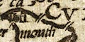
Bridges are drawn by a double line crossing and interrupting the stream; roads are not shown on these maps. About a dozen bridges are shown in Cumbria, none named, and not always the bridges that might be expected? |
|
|
|
||
| lakes |
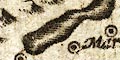
Lakes are drawn by an outline with a shaded shore. One lake is labelled:- Winander mere Other lakes and tarns might be recognized, eg:- Bassenthwaite Lake Buttermere / Crummock Water / Loweswater [muddled together] Derwent Water Thirlmere Ullswater Wast Water |
|
|
|
||
|
relief
hillocks |
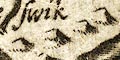
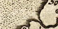
Relief is indicated by small hillocks. At a glance these are scattered pretty freely over the landscape of both maps, but it is possible to see areas with hills such as the plain south of the Solway, and areas of concentration such as the middle of the border with Scotland. No effective portrayal of the relief of the area is provided. Most hills are not labelled. A larger, knobbly hillock is used for a hill in Northumberland labelled:- Suttonside hill But the high hills of Westmorland and Cumberland are not noticed. A valley north of Kirkoswald seems to be labelled:- Gwilderdale but this does no seem to match the valley of River Gelt, or Giltsdale. |
|
|
|
||
| forests |
Woodland is not indicated in Cumbria. Notice three tree
symbols NE of Preston, which might be the Forest of
Bowland?
|
|
|
|
||
| county |
County boundaries are mostly not shown, but the border with Scotland and the border of Northumberland are drawn by a dotted line which is continued alongside a boundary feature such as a river. County areas are labelled, eg:- Wesmorlandia |
|
|
|
||
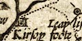
| settlements |
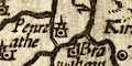
Settlements are marked by a dot and circle, some with
added elements. There does not seem to be a differentiation
of size or importance of settlements. Carlisle has
?buildings and a tower, as do some towns like Egremont and
Kirkoswald, but so does Hartley. Some castles have a tower
as Corby and Daker, but not Pendragon. (Pendragon/Hartley
might just be mixed up.) Appleby has a building on one map
but not on the other.
|
|
| cities |
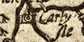
Carlysle |
|
| towns |
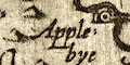
Applebye |
|
| villages |
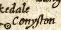
Conyston |
|
Lakes Guides menu.