 Kichin 1750s

|

|
|
|
map type:- Kitchin 1750s |
|
|
|
Maps, Westmoreland, scale about 8 miles to 1 inch, 1753,
and Cumberland, scale about 10.5 miles to 1 inch, 1750, by
Thomas Kitchin, in a monthly series of county maps, London,
1747-60; published 1750s-98.
Published; Westmorland at vol.22 pp.7-8 in the January issue of 'The London Magazine: Or, Gentleman's Monthly Intelligencer. ... Vol.XXII For the Year 1753; Cumberland at vol.19 p.152 in the April issue ,1750. ... Printed for R. Baldwin, at the Rose in Pater Noster Row.' 1753. The map has the coat of arms of Appleby; Cumberland has the arms of Carlisle Cumberland in this series was also published in a Dublin edition of the London Magazine, by Sarah and John Exshaw, The Bible, Cork Hill, Dublin, Ireland, April 1750. Published in 'Historical Descriptions of New and Elegant Picturesque Views of the Antiquities of England and Wales: Being A Grand Copper-Plate Repository of Elegance, Taste, and Entertainment. Containing a new and complete collection of superb views of all the most remarkable Ruins and antient Buildings, such as Abbeys, Castles, Monasteries, Priories ... Accompanied by elegant Letter-Press Descriptions ... To Which Will Be Added ... a Complete Set of County-Maps accurately executed by the best Artists ... Together with an authentic account of Doomsday-Book ... Published under the inspection of Henry Boswell, Esq. F.A.R.S. Assisted by Robert Hamilton, L.L.D. and other ingenious Gentlemen in different Parts of the Kingdom - celebrated for their laborious Researches in the pleasing Study of English Antiquities. London: Printed for Alex. Hogg, at the King's-Arms, No.16, Paternoster-Row, and Sold by all Booksellers, Printsellers, and News-Carriers, in Town and Country,' about 1787-89. Henry Boswell and Robert Hamilton are pseudonyms invented by Hogg for his hack writers. The map is the same but without any imprint, there is no reference to the London Magazine, plain on the reverse; the book has much text; its size is 9 x 15 ins. Published in 'Complete Historical descriptions of A New and Elegant Collection of Picturesque Views and Representations of the Antiquities Of England and Wales: ... To Which Arre Added, ... a Complete Set of the County-Maps of England, Scotland, and Ireland, ... By Henry Boswell, Esq. F.A.S. ... London: Printed for Alex. Hogg, at the King's Arms, (No.16) Paternoster-Row, ...' about 1793. Published in 'The Antiquities Of England and Wales Displayed; Being A Grand Repository of Elegance, Taste, and Entertainment. Containing Copious Historical Descriptions of all the most Remarkable Elegant and Magnificent Ruins and Ancient Buildings; ... including particularly every Article worthy of Notice in that Voluminous and very Expensive Work published By Captain Grose. ... By Henry Boswell, Esq. F.A.S. Assisted by Many Antiquarians, and other Ingenious Gentlemen ... A New Edition, with Alterations And Improvements. London: Printed For Alex. Hogg, At No.16, Paternoster-Row. 1795.' Published in 'A New and Complete Abridgement or Selection of the most Interesting and Important Subjects in the Antiquities of England And Wales: Being A Complete Collection Of Beautiful Views Of The Most Remarkable Buildings And Ancient Ruins Drawn On the Spot. ... By Francis Grose, Esq. F.A.S. To Which Will Be Added ... A Complete Set Of County Maps, By The Best Artists. ... London: Printed for the Editor, and Sold by H.D. Symonds, No.20, and Alex. Hogg, No.16, Paternoster-Row; and may be had of all the Principal Booksellers and Newsmen, in England, wales, Scotland, and Ireland. MDCCXCVIII.' ie 1798. (What is a 'complete abridgement'?) |
||
|
(map example JandMN (53))
|
||
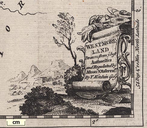
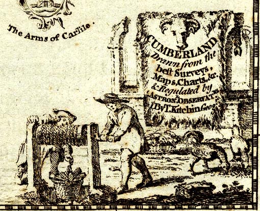
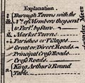
| map feature:- | title cartouche & coat of arms (Appleby) & compass rose & scale line & lat and long scales (trapezoid?) & table of symbols & coast form lines & rivers & lakes & relief & hillocks & woods & settlements & roads | |
| inscription:- |
printed title cartouche
WESTMORE / LAND / Drawn from ye best / Authorities / and Regulated by / Astronl. Observatns. / By T. Kitchin Geogr. bolts of cloth, straw hats, trees |
|
| wxh, sheet:- | 25.5x19.5cm | |
| wxh, map:- | 215x161mm | |
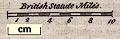
| scale:- | 1 to 500000 ? (1 to 499796 from scale line assuming a statute mile) | |
| scale line:- | 10 miles = 32.2 mm | |
|
||
|
||
| references:- |
: 1753: London Magazine, The & Gentleman's Monthly
Intelligencer: Baldwin, R jnr (London) Boswell, Henry (pseudonym) & Hamilton, Robert (pseudonym): 1787=1789: Historical Descriptions of New and Elegant Picturesque Views of the Antiquities of England and Wales: Hogg, Alexander (London) Boswell, Henry (pseudonym): 1793 (?): Complete Historical Descriptions of A New and Elegant Collection of Picturesque Views and Representation of the Antiquities of England and Wales: Hogg, Alexander (London) Boswell, Henry (pseudonym): Antiquities Of England and Wales Displayed: Hogg, Alexander (London) Grose, Francis (after): 1795: New and Complete Abridgement or Selection of the most Interesting and Important Subjects in the Antiquities of England And Wales: Symonds, H D & Hogg, Alexander (London) |
|
| sources:- |
Chubb 1927 (CLXXXVII) Hodson 1984 JandMN Collection Wordsworth Trust Collection Armitt Library Carlisle Library Maps |
|
| items seen (illustrated items in bold):- | ||

|
Armitt Library : ALMC2008.14.27 -- map -- Westmoreland | |
|
|
Armitt Library : ALMC2008.14.28 -- map -- Westmoreland | |
|
|
Carlisle Library : Map 12 -- map -- Cumberland | |
|
|
Carlisle Library : Map 13 -- map -- Cumberland | |
|
|
Carlisle Library : Map 60 -- map -- Westmoreland | |
|
|
Carlisle Library : Map 61 -- map -- Westmoreland | |
|
|
Dove Cottage : 2007.38.2 -- map -- Westmoreland | |
|
|
Dove Cottage : 2007.38.5 -- map -- Westmoreland | |
|
|
JandMN (53) -- map -- Westmoreland | |
|
|
Kendal Library : Map 30 -- map -- Westmoreland | |
|
|
Kendal Library : Map 31 -- map -- Westmoreland | |
|
|
private collection (171) -- map -- Cumberland | |
|
|
private collection (172) -- map -- Durham | |
|
|
private collection (173) -- map -- North Riding of York Shire | |