 Kitchin 1750s

|

|
|
|
item:- private collection (173) image:- © see bottom of page |
click to enlarge |
|
|
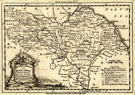
Map, uncoloured engraving, North Riding of York Shire,
scale about 12 miles to 1 inch, by Thomas Kitchin, published
in The London Magazine by R Baldwin, at the Rose,
Paternoster Row, London, 1750s.
|
||

|
Kitchin 1750s | |
| map feature:- | pictorial cartouche & coat of arms & table of symbols & compass rose & up is N & scale line & lat and long scales & sea plain & coast form lines & rivers & relief & hillocks & forests & parks & county & settlements & roads | |
| inscription:- |
printed title cartouche, lower left
THE NORTH RIDING / OF / YORK SHIRE / Drawn from an / ACTULA SURVEY / and Regulated by / ASTRONL. OBSERVATNS. / By T. Kitchin Geogr. |
|
| inscription:- |
printed top, bottom
For the London Magazine / Printed for R. Baldwin Junr. at the Rose in Pater Noster Row. |
|
| inscription:- |
printed above scale line
English Miles |
|
| scale line:- | 12 miles = 25.1 mm | |
| wxh, sheet:- | 22x15.5cm | |
| wxh, map:- | 211x145mm | |
| scale:- | 1 to 770000 ? (1 to 769407 from scale line) | |