 Kitchin 1750s

|

|
|
|
item:- Dove Cottage : 2007.38.5 image:- © see bottom of page |
click to enlarge |
|
|
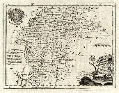
Map, uncoloured engraving, Westmoreland ie Westmorland,
scale about 8 miles to 1 inch, by Thomas Kitchin, first
published in the London Magazine, London, 1753.
Possibly the map as published in Historical Descriptions of New and Elegant Picturesque Views of the Antiquities of England and Wales, published by Alexander Hogg, London, 1787-89. |
||

|
Kitchin 1750s | |
| map feature:- | monumental cartouche & coat of arms (Appleby) & table of symbols & compass rose & up is N & scale line & lat and long scales (W from London, trapezoid projection) & sea plain & coast form lines & rivers & lakes & relief & hillocks & woods & parks & county & settlements & roads | |
| inscription:- |
printed title cartouche, lower right
WESTMORE- / LAND / Drawn from ye. best / Authorities / and Regulated by / Astronl. Observatns. / By T. Kitchin Geogr. roll of woollen cloth, straw hats, etc |
|
| inscription:- |
printed above scale line
British Statue Miles |
|
| scale line:- | 10 miles = 32.2 mm | |
| wxh, sheet:- | 38.5x24.5cm | |
| wxh, plate:- | 225x173mm | |
| wxh, map:- | 217x167mm | |
| scale:- | 1 to 500000 ? (1 to 499796 from scale line) | |