 Kitchin 1750s

|

|
|
|
item:- Dove Cottage : 2007.38.2 image:- © see bottom of page |
click to enlarge |
|
|
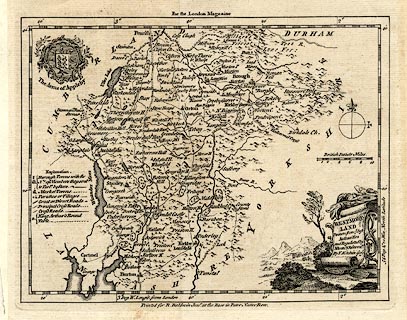
Map, uncoloured engraving, Westmoreland ie Westmorland,
scale about 8 miles to 1 inch, by Thomas Kitchin, published
in the London Magazine by R Baldwin junr at The Rose,
Paternoster Row, London, 1753.
|
||

|
Kitchin 1750s | |
| map feature:- | monumental cartouche & coat of arms (Appleby) & table of symbols & compass rose & up is N & scale line & lat and long scales (W from London, trapezoid projection) & sea plain & coast form lines & rivers & lakes & relief & hillocks & woods & parks & county & settlements & roads | |
| inscription:- |
printed title cartouche, lower right
WESTMORE- / LAND / Drawn from ye. best / Authorities / and Regulated by / Astronl. Observatns. / By T. Kitchin Geogr. roll of woollen cloth, straw hats, etc |
|
| inscription:- |
printed top
For the London Magazine |
|
| inscription:- |
printed bottom
Printed for R. Baldwin Junr. at the Rose in Pater Noster Row. |
|
| inscription:- |
printed above scale line
British Statue Miles |
|
| scale line:- | 10 miles = 32.1 mm | |
| wxh, sheet:- | 24.5x20.5cm | |
| wxh, map:- | 216x165mm | |
| scale:- | 1 to 500000 ? (1 to 501353 from scale line) | |