 Kitchin 1750s

|

|
|
|
item:- private collection (172) image:- © see bottom of page |
click to enlarge |
|
|
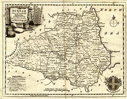
Map, uncoloured engraving, Durham, scale about 7 miles to
1 inch, by Thomas Kitchin, published in The London Magazine
by R Baldwin, at the Rose, Paternoster Row, London, 1750.
Said to be the edn of 1767. |
||

|
Kitchin 1750s | |
| map feature:- | pictorial cartouche & coat of arms (Durham) & table of symbols & compass rose & up is N & scale line & lat and long scales & sea plain & coast form lines & rivers & relief & hillocks & forests & parks & county & settlements & roads | |
| inscription:- |
printed title cartouche, upper left
DURHAM / Drawn from the best / Authorities / and Regulated by / Astronl. Observations / By T. Kitchin Geographr. |
|
| inscription:- |
printed above scale line
British Statute Miles 69 to a Degree |
|
| scale line:- | 12 miles = 44.6 mm | |
| wxh, sheet:- | 22.5x17cm | |
| wxh, map:- | 215x164mm | |
| scale:- | 1 to 430000 ? (1 to 433007 from scale line) | |