 Hogg 1784

|

|
|
|
map type:- Hogg 1784 |
|
|
|
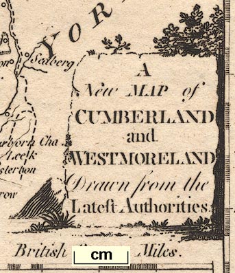
New Map of Cumberland and Westmoreland, scale about 12
miles to 1 inch, on a plate together with Northumberland,
engraved by T Conder, published by Alexander Hogg, London,
1784; published 1784-94.
Published in 'The New British Traveller; Or, A Complete Modern Universal Display Of Great-Britain And Ireland: Being A New, Complete, Accurate, And Extensive Tour Through England, Wales, Scotland, Ireland, the Isles of ... Comprising all that is worthy of Observation in every County, Shire, &c. ... Being calculated equally to please the Polite - entertain the Curious - instruct the Uninformed - and direct the Traveller. ... Being Really The Result Of An actual and late General Survey, accurately made by a Society of Gentlemen, Each of whom has undertaken that Part for which his Study and Inclination has more immediately qualified him. And Including A Valuable Collection of Landscapes, Views, County-Maps, &c. ... The Whole Published Under The Immediate Inspection Of George Augustus Walpoole, Esq. Assisted ... By David Wynne Evans ... Alexander Burnett ... and ... Robert Conway ... And Others ... London: Printed For Alex. Hogg, At The King's-Arms, No.16 Paternoster-Row, 1784.' It is believed that Hogg invented the names - George Augustus Walpoole, David Wynne Evans, Burnett, Robert Conway for his hack writers; as well as the maps there are many pages of text and views. The map is unchanged in further editions. Published in a new edition about 1792. Published in a new edition about 1793. A distinguishing feature of the 1793 edition is the dividing line between counties in the text, it was a double line, it is now a decorative division. Published in another edition 'The New And Complete English Traveller; Or, a New Historical Survey and Modern Description of England and Wales. ... and ... a descriptive Account of a Tour through the English and Scottish Islands ... Written ... by a Society of Gentlemen ... Revised, Corrected, And Improved, by William Hugh Dalton, Esq. ... Enriched and Embellished with ... correct Maps ... London: Printed for Alex. Hogg, No.16, Paternoster-Row; and Sold by the Booksellers of Bath, Bristol ... and by all other Booksellers and Newsmen in England, Wales, Scotland, and Ireland.' about 1794. William Hugh Dalton is likely another pseudonym invented by Hogg. The frontispiece title is 'Daltons New English Traveller ... Published by Alexr. Hogg, Novr. 22, 1794.' The atlas size is 9 x 15 ins. |
||
|
(example map)
|
||
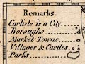
| map feature:- | monumental cartouche & coat of arms & table of symbols & compass rose & up is N & scale line & lat and long scales & sea plain & coast form lines & rivers & lakes & relief & hillocks & woods & trees & forests & parks & county & settlements & roads | |
| inscription:- |
printed title cartouche, lower right
A / New MAP of / CUMBERLAND / and / WESTMORELAND / Drawn from the / Latest Authorities |
|
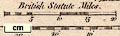
| inscription:- |
printed above scale line
British Statute Miles |
|
| inscription:- |
printed bottom, centre and right
Published by ALEXR. HOGG at the Kings Arms, No.16 PATER NOSTER ROW. / T. Condor Sculpt. |
|
| wxh, map:- | 156x191mm | |
| scale line:- | 20 miles = 42.2 mm | |
| scale:- | 1 to 760000 ? (1 to 762722 from scale line which says statute miles) | |
|
||
|
||
| references:- |
Walpoole, George Augustus (pseudonym) & Evans, David Wynne
(pseudonym) & Burnett, Alexander (pseudonym) & Conway,
Robert (pseudonym): 1784: New British Traveller & Complete
Modern Universal Display of Great-Britain and Ireland: Hogg,
Alexander (London) Dalton, William Hugh (pseudonym): 1794: New and Complete English Traveller & New Historical Survey and Modern Description of England and Wales & Dalton's New English Traveller: Hogg, Alexander (London) |
|
| sources:- |
Chubb 1927 (CCLI) Hodson 1984 private collection Wordsworth Trust Collection Armitt Library |
|
| items seen (illustrated items in bold):- | ||

|
Armitt Library : ALMC2008.14.94 -- map -- New Map of Cumberland and Westmoreland -- New Map of Northumberland | |
|
|
Dove Cottage : 2007.38.101 -- map -- New Map of Cumberland and Westmoreland -- Cumberland and Westmoreland | |
|
|
private collection (68) -- map -- New Map of Cumberland and Westmoreland | |
|
|
private collection (176) -- map -- New Map of Yorkshire | |