 Hogg 1784

|

|
|
|
item:- private collection (68) image:- © see bottom of page |
click to enlarge |
|
|
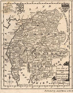
Map, uncoloured engraving, A New Map of Cumberland and
Westmoreland (Northumberland on the same sheet), scale about
12 miles to 1 inch, engraved by T Conder, published by
Alexander Hogg, the Kings Arms, 16 Paternoster Row, London,
1784.
|
||

|
Hogg 1784 | |
| map feature:- | monumental cartouche & coat of arms & table of symbols & compass rose & up is N & scale line & lat and long scales & sea plain & coast form lines & rivers & lakes & relief & hillocks & woods & forests & parks & county & settlements & roads | |
| inscription:- |
printed title cartouche, lower right
A / New MAP of / CUMBERLAND / and / WESTMORELAND / Drawn from the / Latest Authorities |
|
| inscription:- |
printed above scale line
British Statute Miles |
|
| inscription:- |
printed bottom, centre and right
Published by ALEXR. HOGG at the Ki[ ] |
|
| scale line:- | 20 miles = 42.2 mm | |
| scale:- | 1 to 760000 ? (1 to 762722 from scale line which says statute miles) | |
| wxh, map:- | 156x191mm | |
|
|
notes | |