 Hogg 1784

|

|
|

|
back to object record | |
| MAP FEATURES | ||
|
Note that Northumberland was printed on the same sheet, but
is cut off.
|
||
|
|
||
|
title cartouche
monumental cartouche publisher |
Printed lower right on block of stone, trees and a hill
behind, is:-
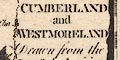
A New MAP of CUMBERLAND and WESTMORELAND Drawn from the Latest Authorities Printed at bottom, centre and right:- Published by ALEXR. HOGG at the Kings Arms, No.16 PATER NOSTER ROW. / T. Condor Sculpt. |
|
|
|
||
| coat of arms |
Two coats of arms are drawn upper left and right,
labelled:-
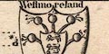
Westmoreland Cumberland |
|
|
|
||
| table of symbols |
Printed upper left are:-
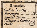
Remarks Carlisle is a City Boroughs ... [circle, tower, asterisk] Market Towns ... [circle, building?] Villages & castles ... [circle, circle with flag] Parks ... [ring of fence palings] |
|
|
|
||
|
orientation
compass rose up is N |
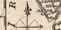
Printed lower left is a compass rose; circle, lines for cardinal directions, dotted lines for half cardinal, North marked by a spear point + fleur de lys, East marked by a cross. The map is printed with North at the top of the sheet. |
|
|
|
||
|
scale line
scale |
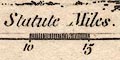
Printed lower right is a scale of:- British Statute Miles chequered in miles to 5 then at 5 mile intervals, labelled at 5, 10, 15, 20. The 20 miles = 42.2 mm gives a map scale 1 to 762722. The map scale is about:- 1 to 760000 12 miles to 1 inch |
|
|
|
||
| lat and long scales |
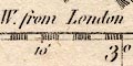
Printed in the map borders are scales of latitude and longitude for a rectangular projection; chequered in 2 minutes intervals, labelled at 10 minute intervals. The bottom scale is labelled:- Longit. W. from London Using the scales the longitude, Kendal = 2d 51m W which suggests a prime meridian 6d E of Greenwich. This is most unlikely; the maps accuracy is not to be trusted that much. |
|
|
|
||
|
sea area
sea plain sandbanks |
The sea area is plain. Some sea areas are labelled,
eg:-
IRISH SEA Moricambo Solway Firth or Eden R. A sandbank is outlined by dotted line off Drigg, labelled:- 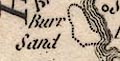
Burr Sand |
|
|
|
||
|
coast line
coast form lines foreshore headlands |
The coast line is emphasized by form lines. Foreshore sands or shallows might be outlined by a dotted line, as in the Solway Firth and off St Bees Head. Headlands are mostly not noticed, but see:- Pt. Drigg |
|
|
|
||
|
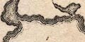
rivers
bridges |
Rivers are drawn by wiggly line tapering upstream. None appear to be labelled; though it is possible to recognise many streams. Bridges are implied where a road crosses and interrupts a stream. |
|
|
|
||
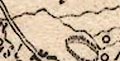
| lakes |
Lakes are drawn in outline with form lines, their sizes
and shapes are poor. Some are labelled:-
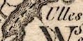
Ulles Broad Water [S of Bridgham] Winandermere Others might be recognized, but with much uncertainty, eg:- Bassenthwaite Lake Burnmoor Tarn (?) Buttermere (?) Crummock Water (?) Derwent Water Devoke Water (?) Ennerdale Water (?) Grasmere (??) Hawes Water Hayes Water Kentmere Tarn Lowes Water (?) Thirlmere Wast Water |
|
|
|
||
|
relief
hillocks |
Relief is indicated by small hillock symbols which are scattered almost anywhere there is a space to put them. Nothing much is labelled, but see:- Derwent Fells |
|
|
|
||
| forests |
Woodland is not indicated. Some forest areas, no trees,
are labelled, eg:-
Thornthwaite Forest Copland Forest |
|
|
|
||
| parks |
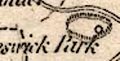
Parks are marked by a ring of fence palings. A few are labelled, eg:- Cunswick Park Uffa Park Others might be recognised by their position or a nearby great house, as at:- Graystock Cast. |
|
|
|
||
| county |
County boundaries are a dashed line which is continued alongside a geographical feature which is the boundary. The county areas are labelled, eg:- WESTMORELAND and adjacent counties are labelled, eg:- DURHAM Very little is plotted outwith the two counties, in particular Lancashire North of the Sands has no map features. |
|
|
|
||
|
settlements
street plan |
Settlements are marked by a circle with added elements,
or by a group of blocks on a street plan, differentiated by
style of labelling.
|
|
| cities |
blocks, street plan; labelled in upright block caps:-
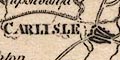
CARLISLE |
|
| towns |
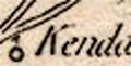
circle, and a vestigial building; labelled in upright
lowercase text, eg:-
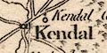
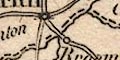
Kendal Ambleside Borough towns have a tower and should have asterisks or tars for members sent to Parliament. Cockermouth has its tower but the stars are missing. Appleby is the county town and is marked by blocks on a street plan; labelled in italic block caps:- APPLEBY but no stars. |
|
|
villages
hamlets houses |
circle; labelled in italic lowercase text, eg:-
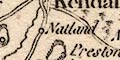
Natland Sleddale Graridge Hall |
|
|
|
||
| roads |
Roads are drawn by double lines, and there is an impression that some roads are bolder than others. As one of the lighter segments is the road from Kendal to Shap and Penrith, the significance of this is doubtful. This route is, in any case, plotted the wrong side of the River Sprint. This error started with the Morden 1695 map and continued through careless copying to this map in 1784. Any of the routes shown should be understood with care. |
|
|
|
||
| miscellaneous | ||
|
|
||
| castles |
Castles are marked by a circle with a flag; labelled in
italic lowercase text, eg:-
Kendal Castle |
|
|
|
||
| stones |
Three upright stones are drawn, one in each county,
labelled:-
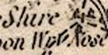
Three Shire Stones upon Wry Nose Head |
|
|
|
||
|
antiquities
roman sites roman wall |
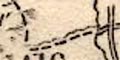
A line with fence palings is drawn across Cumberland from
Boulnesse, by Carlisle, and eastward. Labelled:-
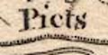
Picts Wall |
|
|
|
||
|
antiquities
earthworks |
A circle and flag near the border on the road east of
Brough is labelled:-
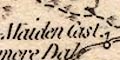
Maiden Cast. |
|
Lakes Guides menu.