 Hogg 1784

|

|
|
|
item:- Dove Cottage : 2007.38.101 image:- © see bottom of page |
click to enlarge |
|
|
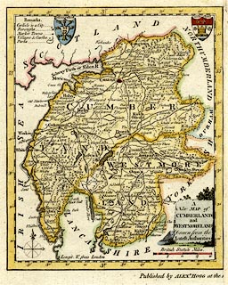
Map, hand coloured engraving, A New Map of Cumberland and
Westmoreland ie Westmorland, scale about 12 miles to 1 inch,
engraved by T Conder, published by Alexander Hogg, the Kings
Arms, 16 Paternoster Row, London, 1784.
Northumberland was printed on the same sheet, notice the incomplete imprint at the bottom, and the strip of paper glued on the right. |
||

|
Hogg 1784 | |
| map feature:- | monumental cartouche & coat of arms & table of symbols & compass rose & up is N & scale line & lat and long scales & sea plain & coast form lines & rivers & lakes & relief & hillocks & woods & forests & parks & county & settlements & roads | |
| inscription:- |
printed title cartouche, lower right
A / New MAP of / CUMBERLAND / and / WESTMORELAND / Drawn from the / Latest Authorities |
|
| inscription:- |
printed above scale line
British Statute Miles |
|
| inscription:- |
printed bottom, centre as was
Published by ALEXR. HOGG at the [ ] |
|
| scale line:- | 20 miles = 42.0 mm | |
| scale:- | 1 to 760000 ? (1 to 766354 from scale line) | |
| wxh, map:- | 156x188mm | |