 Hogg 1784

|

|
|
|
item:- private collection (176) image:- © see bottom of page |
click to enlarge |
|
|
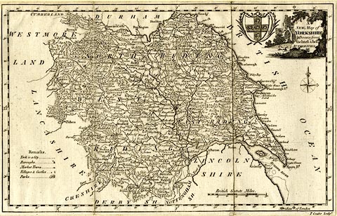
Map, uncoloured engraving, A New Map of Yorkshire, scale
about 14 miles to 1 inch, engraved by T Conder, published by
Alexander Hogg, the Kings Arms, 16 Paternoster Row, London,
1784, edn 1794.
|
||

|
Hogg 1784 | |
| map feature:- | pictorial cartouche & coat of arms (York) & table of symbols & compass rose & up is N & scale line & lat and long scales (rectangular projection?) & sea plain & coast form lines & rivers & relief & hillocks & woods & forests & parks & county & settlements & roads | |
| inscription:- |
printed title cartouche, upper right
A / NEW Map of / YORKSHIRE / Drawn from / the latest & best / AUTHORITES |
|
| inscription:- |
printed bottom right
T. Conder Sculpt. |
|
| inscription:- |
printed above scale line
British Statute Miles. |
|
| scale line:- | 30 miles = 53.7 mm | |
| scale:- | 1 to 900000 ? (1 to 899075 from scale line) | |
| wxh, map:- | 303x191mm | |