 Ford 1829 map

|

|
|
|
map type:- Ford 1839 map |
|
|
|
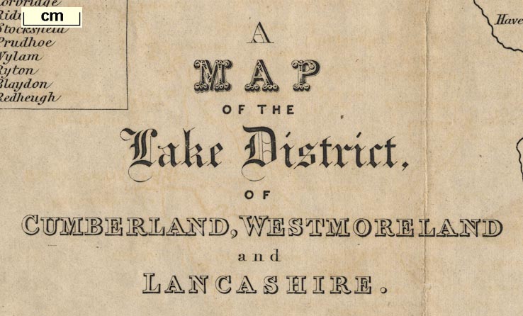
Map of the Lake District of Cumberland, Westmoreland and
Lancashire, scale about 3.5 miles to 1 inch, published by
Charles Thurnam, Carlisle, and by R Groombridge, Paternoster
Row, London, and others, 1839; published 1839-52.
Also three maps of lakes, Windermere, Derwent Water and the Vale of Keswick, and Ulles Water, each with a view of the mountains behind the lake. Published in a guide book, A Description of Scenery in the Lake District, by Rev William Ford, 1839-52. |
||
|
(map example JandMN (100_1))
|
||
| map feature:- | compass rose & up is N & scale line & lat and long scales & sea plain & coast line & rivers & lakes & relief & hill hachuring & forests & parks & county & settlements & roads & railways & canals | |
| inscription:- |
printed lower left
A / MAP / OF THE / Lake District / OF / CUMBERLAND, WESTMORELAND / and / LANCASHIRE. |
|
| wxh, sheet (without added slip):- | 36x49cm | |
| wxh, map (without added slip):- | 358x492mm | |
| scale line:- | 8 miles = 56.5 mm | |
| scale:- | 1 to 230000 ? (1 to 227872 from scale line assuming a statute mile) | |
|
||
| sources:- |
Armitt Library JandMN Collection Carlisle Library Maps |
|
| items seen (illustrated items in bold, * have map squares etc):- | ||

|
Armitt Library : A1128.1 -- map -- Windermere | |
|
|
Armitt Library : A1128.2 -- map -- Derwent Water and Vale of Keswick | |
|
|
Armitt Library : A1128.3 -- map -- Ulles Water | |
|
|
Armitt Library : A1129.1 -- map -- Map of the Lake District of Cumberland, Westmoreland and Lancashire | |
|
|
Armitt Library : A1129.2 -- map -- Windermere | |
|
|
Armitt Library : A1129.3 -- map -- Derwent Water and Vale of Keswick | |
|
|
Armitt Library : A1129.4 -- map -- Ulles Water | |
|
|
Armitt Library : A1130.1 -- map -- Windermere | |
|
|
Armitt Library : A1130.2 -- map -- Derwent Water and Vale of Keswick | |
|
|
Armitt Library : A1130.3 -- map -- Ulles Water | |
|
|
Armitt Library : ALMC2000.21.1 -- map -- Map of the Lake District of Cumberland, Westmoreland and Lancashire | |
|
|
Carlisle Library : Map 83 -- map -- Map of the Lake District of Cumberland, Westmoreland and Lancashire | |
|
|
Carlisle Library : Map 84 -- map -- Map of the Lake District of Cumberland, Westmoreland and Lancashire | |
|
|
Carlisle Library : Map 85 -- map -- small area around Kendal from Map of the Lake District etc. | |
|
|
JandMN (100_1) -- map -- Map of the Lake District of Cumberland, Westmoreland and Lancashire * | |
|
|
JandMN (100_2) -- map -- Windermere | |
|
|
JandMN (100_3) -- map -- Derwent Water and Vale of Keswick | |
|
|
JandMN (100_4) -- map -- Ulles Water | |