 Ford 1839 map

|

|
|
|
item:- Carlisle Library : Map 85 image:- © Carlisle Library |
click to enlarge | |
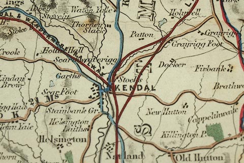
| Illustration of part of map only. | ||
|
Map, hand coloured engraving, Map of the Lake District of
Cumberland, Westmoreland and Lancashire, scale about 3.5
miles to 1 inch, published by Charles Thurnam, Carlisle,
Cumberland, from 1839, edn about 1847?
Taken from a guide book, A Description of Scenery in the Lake District, by Rev William Ford, 1839-52. This version of the map has the Isle of Walney. Printed lower left is a list of stations on the Newcastle and Carlisle Railway. The map has several railways - 'NEWCASTLE AND CARLISLE RAILWAY' drawn to the edge of the map, beyond Haltwhistle, but the extra piece of the earlier map was not used for this version; 'MARYPORT AND CARLISLE RAILWAY'; WHITEHAVEN JUNCTION RAILWAY'; COCKERMOUTH AND WORKINGTON RAILWAY'; 'LANCASTER AND CARLISLE RAILWAY', with interesting routes around Kendal; KENDAL AND WINDERMERE RAILWAY'; and the Caledonian Railway, not labelled. |
||

|
Ford 1839 map | |
| map feature:- | compass rose & up is N & scale line & lat and long scales & sea plain & coast line & coast tinted & rivers & lakes & relief & hill hachuring & forests & parks & county & settlements & roads & road distances & canals & railways | |
| inscription:- |
printed lower left
A / MAP / OF THE / Lake District / OF / CUMBERLAND, WESTMORELAND / and LANCASHIRE. |
|
| inscription:- |
printed bottom
Carlisl[ ] & Published by Charles Thurnam |
|
| inscription:- |
printed with scale line
Statute Miles |
|
| scale line:- | 8 miles = 55.6 mm | |
| wxh, sheet:- | 42x52cm | |
| wxh, map:- | 356x498mm | |
| scale:- | 1 to 230000 ? (1 to 231560 from scale line, assuming a statute mile) | |