 Ford 1839 map

|

|
|
|
item:- JandMN (100_1) image:- © see bottom of page |
click to enlarge |
|

|
menu with map squares and placename index | |
|
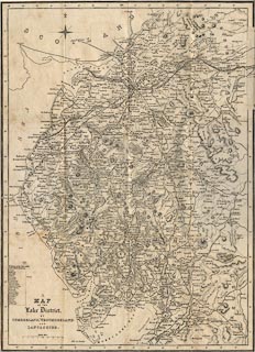
Map, uncoloured engraving, Map of the Lake District of
Cumberland, Westmoreland and Lancashire, scale about 3.5
miles to 1 inch, published by Charles Thurnam, Carlisle, and
by R Groombridge, 5 Paternoster Row, London, 3rd edn 1843.
Mounted on linen, folded 4x3 plus an extension piece tucked in, pasted inside the front cover of A Description of Scenery in the Lake District. The map shows the Newcastle and Carlisle Railway, and Maryport and Carlisle Railway. The added piece of map extends the NandCRy to Newcastle, and the railway from there to North Shields. Notice the list of railway stations on the Newcastle and Carlisle Railway, printed lower left:- Scotby, Wetheral, How Mill, Milton, Low Row, Rosehill, Greenhead, Haltwhistle, etc. Road distances might be given, for example on the road, Lancaster to Carlise, from Lancaster, through Burton, Kendal, Shap, Penrith, to Carlisle - L to B 11 MS. / B to K 11 MS. / K to S 16 MS. / S to P 11 MS. / P to C 18 MS. |
||
|
|
Ford 1839 map | |
| map feature:- | compass rose & up is N & scale line & lat and long scales & sea plain & coast line & rivers & lakes & relief & hill hachuring & forests & parks & county & settlements & roads & road distances & railways & canals | |
| inscription:- |
printed lower left
A / MAP / OF THE / Lake District / OF / CUMBERLAND, WESTMORELAND / and / LANCASHIRE. |
|
| scale line:- | 8 miles = 56.5 mm | |
| wxh, sheet (without added slip):- | 36x49cm | |
| wxh, map (without added slip):- | 358x492mm | |
| scale:- | 1 to 230000 ? (1 to 227872 from scale line assuming a statute mile) | |
|
|
notes | |